Photographic Print > Europe > Portugal > Maps
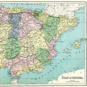
Photographic Print : Map of Spain and Portugal 1896


![]()
Photo Prints from Fine Art Storehouse
Map of Spain and Portugal 1896
Andres Allgemeiner Handatlas - Bielefeld und Leipzig 1896
Unleash your creativity and transform your space into a visual masterpiece!
THEPALMER
Media ID 18356841
10"x8" Photo Print
Discover the rich history and culture of Europe's Iberian Peninsula with our exquisite "Map of Spain and Portugal 1896" photographic print from the Media Storehouse Fine Art Collection. Meticulously sourced from the Andres Allgemeiner Handatlas published in Bielefeld and Leipzig in 1896, this vintage map showcases intricate cartographic details and captivating illustrations of the regions' geography, borders, and notable cities during a fascinating period in history. Bring a piece of the past into your home or office with this beautifully preserved and expertly printed photographic art piece, perfect for history enthusiasts, cartographers, or anyone who appreciates the aesthetic charm of antique maps.
Photo prints are produced on Kodak professional photo paper resulting in timeless and breath-taking prints which are also ideal for framing. The colors produced are rich and vivid, with accurate blacks and pristine whites, resulting in prints that are truly timeless and magnificent. Whether you're looking to display your prints in your home, office, or gallery, our range of photographic prints are sure to impress. Dimensions refers to the size of the paper in inches.
Our Photo Prints are in a large range of sizes and are printed on Archival Quality Paper for excellent colour reproduction and longevity. They are ideal for framing (our Framed Prints use these) at a reasonable cost. Alternatives include cheaper Poster Prints and higher quality Fine Art Paper, the choice of which is largely dependant on your budget.
Estimated Product Size is 25.4cm x 20.3cm (10" x 8")
These are individually made so all sizes are approximate
Artwork printed orientated as per the preview above, with landscape (horizontal) or portrait (vertical) orientation to match the source image.
FEATURES IN THESE COLLECTIONS
> Fine Art Storehouse
> Map
> Historical Maps
> Europe
> Portugal
> Related Images
> Europe
> Spain
> Related Images
> Maps and Charts
> Related Images
> Maps and Charts
> Spain
EDITORS COMMENTS
This print showcases a remarkable piece of history - the "Map of Spain and Portugal 1896" from Andres Allgemeiner Handatlas. With its intricate details and vintage charm, this map takes us back to a time when cartography was both an art form and a vital tool for exploration. The map, expertly crafted in Bielefeld und Leipzig in 1896, offers a fascinating glimpse into the political boundaries, geographical features, and cultural nuances of Spain and Portugal during that era. From the majestic Pyrenees Mountains to the sun-kissed coastlines along the Mediterranean Sea, every corner of these Iberian lands is meticulously depicted. As we delve deeper into this historical gem by THEPALMER at Fine Art Storehouse, we can't help but appreciate how it transports us to a different time - an age where travel was more arduous yet filled with endless possibilities. The delicate lines tracing rivers and borders remind us of countless journeys taken by explorers who sought knowledge beyond their own horizons. Whether you're an avid traveler or simply fascinated by history's unfolding tapestry, this print serves as both an educational resource and a stunning work of art. It invites us to marvel at the craftsmanship involved in creating such detailed maps before modern technology revolutionized cartography. Hang this exquisite piece on your wall or gift it to someone with wanderlust in their heart; let it inspire curiosity about our world's past while adding timeless elegance to any space.
MADE IN THE USA
Safe Shipping with 30 Day Money Back Guarantee
FREE PERSONALISATION*
We are proud to offer a range of customisation features including Personalised Captions, Color Filters and Picture Zoom Tools
SECURE PAYMENTS
We happily accept a wide range of payment options so you can pay for the things you need in the way that is most convenient for you
* Options may vary by product and licensing agreement. Zoomed Pictures can be adjusted in the Cart.