Photographic Print > Asia > Philippines > Maps
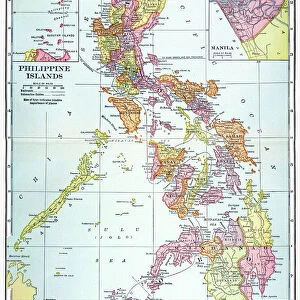
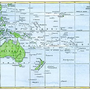
Photographic Print : Philippines islands map 1898


![]()
Photo Prints from Fine Art Storehouse
Philippines islands map 1898
Unleash your creativity and transform your space into a visual masterpiece!
THEPALMER
Media ID 14756928
© This content is subject to copyright
10"x8" Photo Print
Discover the rich history of the Philippines with our exquisite print of the "Philippines Islands Map 1898" by THEPALMER from the Media Storehouse Fine Art Collection. This captivating vintage map transports you back in time, illustrating the islands as they were known before the turn of the century. Perfect for history enthusiasts, world travelers, or those who appreciate the beauty of cartography, this high-quality print makes a stunning addition to any room. Experience the past in vivid detail and bring a piece of history into your home or office.
Photo prints are produced on Kodak professional photo paper resulting in timeless and breath-taking prints which are also ideal for framing. The colors produced are rich and vivid, with accurate blacks and pristine whites, resulting in prints that are truly timeless and magnificent. Whether you're looking to display your prints in your home, office, or gallery, our range of photographic prints are sure to impress. Dimensions refers to the size of the paper in inches.
Our Photo Prints are in a large range of sizes and are printed on Archival Quality Paper for excellent colour reproduction and longevity. They are ideal for framing (our Framed Prints use these) at a reasonable cost. Alternatives include cheaper Poster Prints and higher quality Fine Art Paper, the choice of which is largely dependant on your budget.
Estimated Product Size is 20.3cm x 25.4cm (8" x 10")
These are individually made so all sizes are approximate
Artwork printed orientated as per the preview above, with landscape (horizontal) or portrait (vertical) orientation to match the source image.
FEATURES IN THESE COLLECTIONS
> Fine Art Storehouse
> Map
> Historical Maps
> Asia
> Philippines
> Maps
> Asia
> Philippines
> Related Images
> Maps and Charts
> Related Images
EDITORS COMMENTS
This print titled "Philippines islands map 1898" takes us on a journey back in time to the year when the Philippines was under American rule. The intricate details and historical significance of this map make it a true gem for history enthusiasts and art lovers alike. The image showcases an exquisite reproduction of the original 1898 map, meticulously crafted by THEPALMER. Every contour, coastline, and island is beautifully depicted, offering a glimpse into the archipelago's geography during that era. The fine lines and delicate shading bring out the rich topography of these enchanting islands. As we gaze upon this piece, our imagination transports us to a time when colonial powers were shaping the destiny of nations. It serves as a reminder of how borders have evolved over time and how cultures have intertwined within these lands. The artist's attention to detail is evident in every stroke, capturing not only geographical accuracy but also evoking emotions associated with exploration and discovery. This artwork invites viewers to delve deeper into Philippine history while appreciating its aesthetic appeal. Whether displayed in homes or educational institutions, this print from Fine Art Storehouse sparks conversations about heritage, identity, and our collective past. It stands as both an artistic masterpiece and an invaluable historical artifact that connects us with our roots.
MADE IN THE USA
Safe Shipping with 30 Day Money Back Guarantee
FREE PERSONALISATION*
We are proud to offer a range of customisation features including Personalised Captions, Color Filters and Picture Zoom Tools
SECURE PAYMENTS
We happily accept a wide range of payment options so you can pay for the things you need in the way that is most convenient for you
* Options may vary by product and licensing agreement. Zoomed Pictures can be adjusted in the Cart.