Photographic Print > Europe > Portugal > Maps
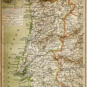
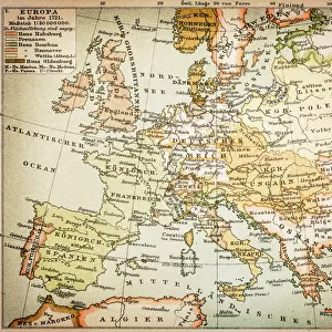
Photographic Print : Spain and Portugal map 1895


![]()
Photo Prints from Fine Art Storehouse
Spain and Portugal map 1895
Meyers Konversations-Lexikon. Ein Nachschlagewerk des allgemeinen Wissens, 5th edition 17 volumes Bibliographisches Institut - Leipzig 1895-1897
Unleash your creativity and transform your space into a visual masterpiece!
THEPALMER
Media ID 13609325
© This content is subject to copyright
10"x8" Photo Print
Step back in time with our exquisite 'Spain and Portugal Map 1895' print from THEPALMER's collection at Media Storehouse. This stunning vintage map, originally published in the Meyers Konversations-Lexikon, offers a captivating glimpse into the historical geography of Europe during the late 19th century. Bring the rich history of Spain and Portugal into your home or office with this beautiful, museum-quality fine art print.
Photo prints are produced on Kodak professional photo paper resulting in timeless and breath-taking prints which are also ideal for framing. The colors produced are rich and vivid, with accurate blacks and pristine whites, resulting in prints that are truly timeless and magnificent. Whether you're looking to display your prints in your home, office, or gallery, our range of photographic prints are sure to impress. Dimensions refers to the size of the paper in inches.
Our Photo Prints are in a large range of sizes and are printed on Archival Quality Paper for excellent colour reproduction and longevity. They are ideal for framing (our Framed Prints use these) at a reasonable cost. Alternatives include cheaper Poster Prints and higher quality Fine Art Paper, the choice of which is largely dependant on your budget.
Estimated Product Size is 25.4cm x 20.3cm (10" x 8")
These are individually made so all sizes are approximate
Artwork printed orientated as per the preview above, with landscape (horizontal) or portrait (vertical) orientation to match the source image.
FEATURES IN THESE COLLECTIONS
> Fine Art Storehouse
> Map
> Historical Maps
> Europe
> Portugal
> Related Images
> Maps and Charts
> Related Images
> Maps and Charts
> Spain
EDITORS COMMENTS
This print showcases a remarkable piece of history, the Spain and Portugal map from 1895. Taken from the renowned Meyers Konversations-Lexikon, this antique treasure offers a glimpse into the past with its intricate details and exquisite craftsmanship. The map, presented in a horizontal format, captures the physical geography of both countries during that era. Engraved and etched with precision, this illustration is a testament to the artistry of cartography in the late 19th century. The fine lines and delicate shading bring to life every contour of Spain's diverse landscapes and Portugal's coastal beauty. It serves as a visual time capsule, transporting us back to an era when exploration was at its peak. The aged appearance adds an air of authenticity to this vintage gem. Its weathered edges tell stories of countless hands tracing their fingers over its surface throughout generations. As we gaze upon it today, we are reminded of how far our understanding of these lands has come since then. "The Palmer" through Fine Art Storehouse, has skillfully captured this historical artifact for all to admire. This print allows us to appreciate not only the geographical accuracy but also the artistic mastery behind such maps from yesteryears. Whether you're an avid collector or simply fascinated by history, this enchanting piece will undoubtedly add depth and character to any space it graces
MADE IN THE USA
Safe Shipping with 30 Day Money Back Guarantee
FREE PERSONALISATION*
We are proud to offer a range of customisation features including Personalised Captions, Color Filters and Picture Zoom Tools
SECURE PAYMENTS
We happily accept a wide range of payment options so you can pay for the things you need in the way that is most convenient for you
* Options may vary by product and licensing agreement. Zoomed Pictures can be adjusted in the Cart.