Photographic Print > Arts > Photorealistic artworks > Detailed art pieces > Masterful detailing in art
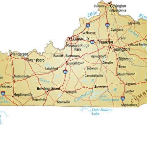
Photographic Print : Kentucky Vector Map


![]()
Photo Prints from Fine Art Storehouse
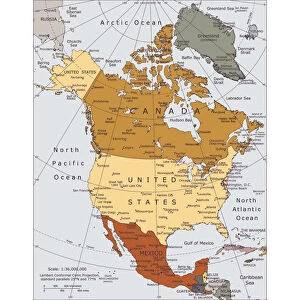
Kentucky Vector Map
Highly detailed vector map of Kentucky, United States. Source data courtesy of NGDC (database: World Data Bank II), NASA (reference images: Blue Marble) and National Atlas (database: county boundaries). The source data is in the public domain. Data updated and improved. File was created on May 22, 2013. The colors in the.eps-file are ready for print (CMYK). Included files: EPS (v8) and Hi-Res JPG (5600aua5600 px)
Unleash your creativity and transform your space into a visual masterpiece!
Media ID 14833471
10"x10" Photo Print
Discover the captivating beauty of Kentucky with our exquisite Fine Art Storehouse Photographic Print of the highly detailed Vector Map. Meticulously crafted from source data courtesy of NGDC, NASA, and the National Atlas, this stunning representation of the United States' Bluegrass State is a testament to our commitment to precision and artistic excellence. Bring the rich history and distinctive character of Kentucky into your home or office with this unique and thought-provoking piece.
Photo prints are produced on Kodak professional photo paper resulting in timeless and breath-taking prints which are also ideal for framing. The colors produced are rich and vivid, with accurate blacks and pristine whites, resulting in prints that are truly timeless and magnificent. Whether you're looking to display your prints in your home, office, or gallery, our range of photographic prints are sure to impress. Dimensions refers to the size of the paper in inches.
Our Photo Prints are in a large range of sizes and are printed on Archival Quality Paper for excellent colour reproduction and longevity. They are ideal for framing (our Framed Prints use these) at a reasonable cost. Alternatives include cheaper Poster Prints and higher quality Fine Art Paper, the choice of which is largely dependant on your budget.
Estimated Product Size is 25.4cm x 25.4cm (10" x 10")
These are individually made so all sizes are approximate
Artwork printed orientated as per the preview above, with landscape (horizontal) or portrait (vertical) orientation to match the source image.
FEATURES IN THESE COLLECTIONS
> Fine Art Storehouse
> Map
> Map Illustrations
> Arts
> Photorealistic artworks
> Detailed art pieces
> Masterful detailing in art
> Maps and Charts
> Related Images
> Maps and Charts
> World
> Science
> Space Exploration
> Related Images
EDITORS COMMENTS
This highly detailed vector map of Kentucky showcases the beauty and intricacies of this state in the United States. Created using source data from NGDC, NASA, and National Atlas, this print is a testament to the collaborative efforts of these esteemed organizations. The rich colors in the . eps-file are specifically designed for print (CMYK), ensuring that every detail is vividly captured. Whether you choose to display it in your home or office, this map will undoubtedly serve as an eye-catching centerpiece. With updated and improved data, this print offers an accurate representation of Kentucky's geography and county boundaries. The meticulous craftsmanship behind its creation guarantees precision and authenticity. As a bonus, included with your purchase are EPS (v8) and Hi-Res JPG files, allowing you to explore different ways to enjoy this stunning artwork. From digital displays to high-quality prints on various mediums, the possibilities are endless.
MADE IN THE USA
Safe Shipping with 30 Day Money Back Guarantee
FREE PERSONALISATION*
We are proud to offer a range of customisation features including Personalised Captions, Color Filters and Picture Zoom Tools
SECURE PAYMENTS
We happily accept a wide range of payment options so you can pay for the things you need in the way that is most convenient for you
* Options may vary by product and licensing agreement. Zoomed Pictures can be adjusted in the Cart.