Photographic Print > Europe > United Kingdom > Related Images
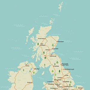
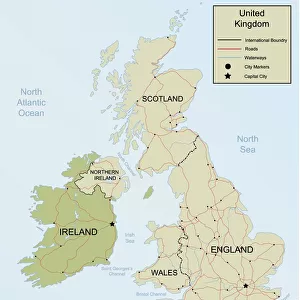
Photographic Print : United Kingdom country map


![]()
Photo Prints from Fine Art Storehouse
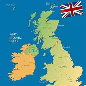
United Kingdom country map
2011 edition
Unleash your creativity and transform your space into a visual masterpiece!
Media ID 14432157
10"x8" Photo Print
Add a touch of British charm to your home or office with the United Kingdom Country Map Fine Art Print from Media Storehouse. This exquisite piece, taken from the 2011 edition, showcases the intricate details of the United Kingdom's borders and regions in stunning, high-quality detail. Each print is carefully crafted using premium materials and fine art printing techniques, ensuring a beautiful and long-lasting addition to your space. Whether you're an avid traveler or simply a proud Brit, this map print is the perfect way to celebrate the rich heritage and culture of the United Kingdom. Order yours today and let the beauty of this fine art print inspire you every day.
Photo prints are produced on Kodak professional photo paper resulting in timeless and breath-taking prints which are also ideal for framing. The colors produced are rich and vivid, with accurate blacks and pristine whites, resulting in prints that are truly timeless and magnificent. Whether you're looking to display your prints in your home, office, or gallery, our range of photographic prints are sure to impress. Dimensions refers to the size of the paper in inches.
Our Photo Prints are in a large range of sizes and are printed on Archival Quality Paper for excellent colour reproduction and longevity. They are ideal for framing (our Framed Prints use these) at a reasonable cost. Alternatives include cheaper Poster Prints and higher quality Fine Art Paper, the choice of which is largely dependant on your budget.
Estimated Product Size is 20.3cm x 25.4cm (8" x 10")
These are individually made so all sizes are approximate
Artwork printed orientated as per the preview above, with landscape (horizontal) or portrait (vertical) orientation to match the source image.
FEATURES IN THESE COLLECTIONS
> Fine Art Storehouse
> Map
> Reference Maps
> Europe
> United Kingdom
> Related Images
> Maps and Charts
> Related Images
EDITORS COMMENTS
This print showcases the United Kingdom country map, specifically the 2011 edition. With intricate details and vibrant colors, this piece from Fine Art Storehouse is a true masterpiece that captures the essence of this historic nation. The map itself is meticulously crafted, highlighting every city, town, and village across England, Scotland, Wales, and Northern Ireland. From bustling metropolises like London and Edinburgh to charming coastal towns like Brighton and St Ives - each location is clearly marked with precision. What makes this particular print stand out is its ability to transport you into a world of exploration. As your eyes wander across the map's surface, you can't help but imagine embarking on an adventure through these diverse landscapes. Whether it's hiking in the breathtaking Scottish Highlands or exploring ancient castles in Wales - there are endless possibilities waiting to be discovered within these borders. As you admire this artwork on your wall or desk, it serves as a constant reminder of the rich history and cultural heritage that defines the United Kingdom. It sparks curiosity about its people, traditions, landmarks, and even local delicacies such as fish and chips or haggis! This print from Fine Art Storehouse encapsulates more than just geographical information; it captures a sense of national pride for those who call this beautiful island home or have fond memories of their time spent here.
MADE IN THE USA
Safe Shipping with 30 Day Money Back Guarantee
FREE PERSONALISATION*
We are proud to offer a range of customisation features including Personalised Captions, Color Filters and Picture Zoom Tools
SECURE PAYMENTS
We happily accept a wide range of payment options so you can pay for the things you need in the way that is most convenient for you
* Options may vary by product and licensing agreement. Zoomed Pictures can be adjusted in the Cart.