Photographic Print > Africa > Zambia > Maps
Photographic Print : Zambia country map


Resolution may be reduced at this size (115 DPI)
![]()
Photo Prints from Fine Art Storehouse
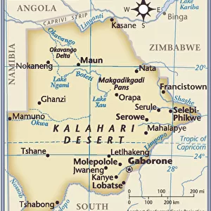
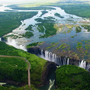
Zambia country map
2011 edition
Unleash your creativity and transform your space into a visual masterpiece!
Media ID 15154191
10"x8" Photo Print
Photo prints are produced on Kodak professional photo paper resulting in timeless and breath-taking prints which are also ideal for framing. The colors produced are rich and vivid, with accurate blacks and pristine whites, resulting in prints that are truly timeless and magnificent. Whether you're looking to display your prints in your home, office, or gallery, our range of photographic prints are sure to impress. Dimensions refers to the size of the paper in inches.
Our Photo Prints are in a large range of sizes and are printed on Archival Quality Paper for excellent colour reproduction and longevity. They are ideal for framing (our Framed Prints use these) at a reasonable cost. Alternatives include cheaper Poster Prints and higher quality Fine Art Paper, the choice of which is largely dependant on your budget.
Estimated Product Size is 25.4cm x 20.3cm (10" x 8")
These are individually made so all sizes are approximate
Artwork printed orientated as per the preview above, with landscape (horizontal) orientation to match the source image.
FEATURES IN THESE COLLECTIONS
> Fine Art Storehouse
> Map
> Reference Maps
> Africa
> Zambia
> Related Images
> Maps and Charts
> Related Images
EDITORS COMMENTS
This print showcases the intricate details of a Zambia country map, specifically the 2011 edition. With its vibrant colors and precise cartographic features, this artwork from Fine Art Storehouse is a true testament to the beauty of geography. The map effortlessly captures the vastness and diversity of Zambia's landscape, stretching from its northern borders with Tanzania and Democratic Republic of Congo to its southern boundaries with Zimbabwe and Botswana. Every river, mountain range, and national park is meticulously depicted, allowing viewers to immerse themselves in this enchanting African nation. As you gaze upon this stunning piece, your eyes will be drawn to Lusaka - the bustling capital city located at the heart of Zambia. From there, your exploration can extend towards iconic landmarks such as Victoria Falls on the border with Zimbabwe or Lake Tanganyika in the northwest region. Beyond geographical accuracy lies an underlying sense of adventure that emanates from this photograph. It invites you to embark on a journey through Zambia's rich cultural heritage and diverse wildlife habitats. Whether it's exploring traditional villages or encountering majestic elephants roaming freely across vast plains, every corner holds a new discovery waiting to be made. This print serves as both an educational tool for geography enthusiasts and an exquisite decorative piece for any space. Its timeless appeal transcends time itself while capturing a moment frozen in history – making it perfect for those seeking visual inspiration or simply wishing to celebrate their love for travel and exploration.
MADE IN THE USA
Safe Shipping with 30 Day Money Back Guarantee
FREE PERSONALISATION*
We are proud to offer a range of customisation features including Personalised Captions, Color Filters and Picture Zoom Tools
SECURE PAYMENTS
We happily accept a wide range of payment options so you can pay for the things you need in the way that is most convenient for you
* Options may vary by product and licensing agreement. Zoomed Pictures can be adjusted in the Cart.