Photographic Print > Europe > United Kingdom > England > Kent > Green Street Green
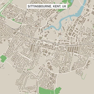
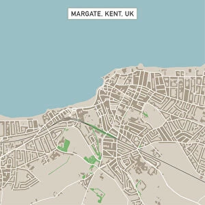
Photographic Print : Margate Kent UK City Street Map


![]()
Photo Prints from Fine Art Storehouse
Margate Kent UK City Street Map
Vector Illustration of a City Street Map of Margate, Kent, UK. Included files are EPS (v10) and Hi-Res JPG.
Data courtesy from Ordnance Survey: VectorMap District
https:/ordnancesurvey.co.uk/business-and-government/products/vectormap-district.html
OS OpenData is free to use under the Open Government Licence (OGL).
Contains OS data eCrown copyright and database right 2017.
http:/nationalarchives.gov.uk/doc/open-government-licence/version/3/
Unleash your creativity and transform your space into a visual masterpiece!
Frank Ramspott
Media ID 15055227
© Frank Ramspott, all rights reserved
Aerial View Computer Graphic Directly Above Gray Green Kent North Sea Road Map Street Map Text Digitally Generated Image Margate
10"x10" Photo Print
Discover the charm of Margate, Kent, UK, with this exquisite City Street Map print from the Media Storehouse Fine Art Collection. Created by renowned artist Frank Ramspott, this vector illustration brings the intricate details of the city's streets to life. The included EPS (version 10) and Hi-Res JPG files ensure a crisp, high-definition image, making it perfect for both personal and commercial use. Backed by Ordnance Survey's detailed VectorMap District data, this print is an accurate and beautiful representation of Margate's urban landscape. Bring a piece of this historic seaside town into your home or office today.
Photo prints are produced on Kodak professional photo paper resulting in timeless and breath-taking prints which are also ideal for framing. The colors produced are rich and vivid, with accurate blacks and pristine whites, resulting in prints that are truly timeless and magnificent. Whether you're looking to display your prints in your home, office, or gallery, our range of photographic prints are sure to impress. Dimensions refers to the size of the paper in inches.
Our Photo Prints are in a large range of sizes and are printed on Archival Quality Paper for excellent colour reproduction and longevity. They are ideal for framing (our Framed Prints use these) at a reasonable cost. Alternatives include cheaper Poster Prints and higher quality Fine Art Paper, the choice of which is largely dependant on your budget.
Estimated Product Size is 25.4cm x 25.4cm (10" x 10")
These are individually made so all sizes are approximate
Artwork printed orientated as per the preview above, with landscape (horizontal) or portrait (vertical) orientation to match the source image.
FEATURES IN THESE COLLECTIONS
> Fine Art Storehouse
> Map
> Street Maps
> Aerial Photography
> Related Images
> Arts
> Contemporary art
> Digital artwork
> Street art
> Arts
> Portraits
> Pop art gallery
> Street art portraits
> Arts
> Street art graffiti
> Digital art
> Digital paintings
> Arts
> Street art graffiti
> Digital art
> Vector illustrations
> Europe
> United Kingdom
> England
> Kent
> Green Street Green
> Europe
> United Kingdom
> England
> Kent
> Kent Street
> Europe
> United Kingdom
> England
> Kent
> Margate
> Europe
> United Kingdom
> England
> Kent
> North Street
> Europe
> United Kingdom
> Maps
EDITORS COMMENTS
This print showcases a beautifully detailed city street map of Margate, Kent, UK. The vector illustration captures the essence of this charming coastal town, highlighting its intricate road network and architectural landmarks. With files available in EPS (v10) and Hi-Res JPG formats, this print offers versatility for various design projects. The data used to create this stunning artwork is courtesy of Ordnance Survey: VectorMap District. This reliable source ensures accuracy and authenticity in depicting the city's layout. Moreover, it is worth mentioning that OS OpenData allows free usage under the Open Government Licence (OGL), emphasizing transparency and accessibility. The image portrays Margate's unique location on the North Sea coastline, showcasing its close connection to nature. The combination of gray, green, blue, and white hues adds vibrancy to the digitally generated design while maintaining a sense of realism. With no people present in the picture, viewers can focus solely on appreciating the intricate cartography displayed from an aerial perspective directly above Margate. This computer graphic provides a comprehensive overview of the city's streetscape without distractions. Overall, Frank Ramspott has skillfully captured both the physical geography and cultural significance of Margate through this visually striking photo print. It serves as a testament to his talent as an artist and celebrates all that makes this seaside town truly special.
MADE IN THE USA
Safe Shipping with 30 Day Money Back Guarantee
FREE PERSONALISATION*
We are proud to offer a range of customisation features including Personalised Captions, Color Filters and Picture Zoom Tools
SECURE PAYMENTS
We happily accept a wide range of payment options so you can pay for the things you need in the way that is most convenient for you
* Options may vary by product and licensing agreement. Zoomed Pictures can be adjusted in the Cart.