Photographic Print > Aerial Photography > Related Images
Photographic Print : Plano Texas US City Street Map


![]()
Photo Prints from Fine Art Storehouse
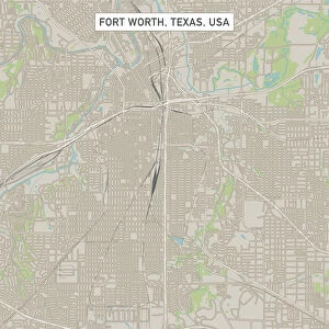
Plano Texas US City Street Map
Vector Illustration of a City Street Map of Plano, Texas, USA. Scale 1:60, 000.
All source data is in the public domain.
U.S. Geological Survey, US Topo
Used Layers:
USGS The National Map: National Hydrography Dataset (NHD)
USGS The National Map: National Transportation Dataset (NTD)
Unleash your creativity and transform your space into a visual masterpiece!
Frank Ramspott
Media ID 15192974
© Frank Ramspott, all rights reserved
Aerial View City Map Computer Graphic Directly Above Downtown District Gray Road Map Texas Text Digitally Generated Image Green Color White Color
10"x10" Photo Print
Discover the charm of Plano, Texas with our exquisite "Plano Texas US City Street Map" print from the Media Storehouse Fine Art collection. This stunning vector illustration, created by talented artist Frank Ramspott, offers a detailed and accurate representation of the city's streets at a scale of 1:60,000. Each print is meticulously crafted using public domain data, ensuring the highest quality and authenticity. Bring the essence of Plano into your home or office and elevate your decor with this unique and captivating work of art.
Photo prints are produced on Kodak professional photo paper resulting in timeless and breath-taking prints which are also ideal for framing. The colors produced are rich and vivid, with accurate blacks and pristine whites, resulting in prints that are truly timeless and magnificent. Whether you're looking to display your prints in your home, office, or gallery, our range of photographic prints are sure to impress. Dimensions refers to the size of the paper in inches.
Our Photo Prints are in a large range of sizes and are printed on Archival Quality Paper for excellent colour reproduction and longevity. They are ideal for framing (our Framed Prints use these) at a reasonable cost. Alternatives include cheaper Poster Prints and higher quality Fine Art Paper, the choice of which is largely dependant on your budget.
Estimated Product Size is 25.4cm x 25.4cm (10" x 10")
These are individually made so all sizes are approximate
Artwork printed orientated as per the preview above, with landscape (horizontal) or portrait (vertical) orientation to match the source image.
FEATURES IN THESE COLLECTIONS
> Fine Art Storehouse
> Map
> Street Maps
> Fine Art Storehouse
> Map
> USA Maps
> Aerial Photography
> Related Images
> Animals
> Insects
> Hemiptera
> Green Scale
> Arts
> Contemporary art
> Digital artwork
> Street art
> Arts
> Landscape paintings
> Waterfall and river artworks
> River artworks
> Arts
> Portraits
> Pop art gallery
> Street art portraits
> Arts
> Street art graffiti
> Digital art
> Digital paintings
> Arts
> Street art graffiti
> Digital art
> Vector illustrations
> Maps and Charts
> Geological Map
> Maps and Charts
> Related Images
> North America
> United States of America
> Lakes
> Related Images
EDITORS COMMENTS
This print showcases a meticulously crafted city street map of Plano, Texas, USA. With an impressive scale of 1:60,000, every intricate detail is brought to life in this vector illustration. The source data used for this artwork is from the public domain and provided by the U. S. Geological Survey's National Hydrography Dataset (NHD) and National Transportation Dataset (NTD), ensuring accuracy and reliability. The image captures the essence of Plano's downtown district, featuring its vibrant streets, serene lake, and meandering river. This digitally generated map effortlessly combines elements of design and cartography to create a visually stunning representation of the city. From roads to landmarks, every aspect has been thoughtfully included. Presented in shades of gray with pops of blue, white, and green colors strategically placed throughout the composition add depth and visual interest. The aerial view perspective allows viewers to appreciate Plano's physical geography from directly above. With no people present in the image itself but accompanied by informative text providing context about its creation process as well as copyright details attributed to Frank Ramspott – this print serves as both an artistic masterpiece and a functional tool for navigation enthusiasts or those seeking a unique piece that celebrates their connection with Plano's urban landscape.
MADE IN THE USA
Safe Shipping with 30 Day Money Back Guarantee
FREE PERSONALISATION*
We are proud to offer a range of customisation features including Personalised Captions, Color Filters and Picture Zoom Tools
SECURE PAYMENTS
We happily accept a wide range of payment options so you can pay for the things you need in the way that is most convenient for you
* Options may vary by product and licensing agreement. Zoomed Pictures can be adjusted in the Cart.