Photographic Print > Africa > Morocco > Maps
Photographic Print : Map of Algeria, Morocco, Tunisia, 1900


![]()
Photo Prints from Fine Art Storehouse
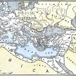
Map of Algeria, Morocco, Tunisia, 1900
Meyers hand-Atlas Leipzig und Wien Verlag des Bibliographischen Instituts 1900
Unleash your creativity and transform your space into a visual masterpiece!
THEPALMER
Media ID 18356597
10"x8" Photo Print
Step back in time with our exquisite vintage Map of Algeria, Morocco, and Tunisia print from THEPALMER's collection at Media Storehouse. This beautiful piece is taken from the 1900 edition of Meyer's Hand-Atlas, published by the Bibliographisches Institut in Leipzig and Wien. The intricate details and authentic cartography of this antique map transport you to a bygone era. Bring history into your home or office with this unique and captivating work of art.
Photo prints are produced on Kodak professional photo paper resulting in timeless and breath-taking prints which are also ideal for framing. The colors produced are rich and vivid, with accurate blacks and pristine whites, resulting in prints that are truly timeless and magnificent. Whether you're looking to display your prints in your home, office, or gallery, our range of photographic prints are sure to impress. Dimensions refers to the size of the paper in inches.
Our Photo Prints are in a large range of sizes and are printed on Archival Quality Paper for excellent colour reproduction and longevity. They are ideal for framing (our Framed Prints use these) at a reasonable cost. Alternatives include cheaper Poster Prints and higher quality Fine Art Paper, the choice of which is largely dependant on your budget.
Estimated Product Size is 25.4cm x 20.3cm (10" x 8")
These are individually made so all sizes are approximate
Artwork printed orientated as per the preview above, with landscape (horizontal) orientation to match the source image.
FEATURES IN THESE COLLECTIONS
> Fine Art Storehouse
> Map
> Historical Maps
> Fine Art Storehouse
> Travel Imagery
> Travel Destinations
> Morocco, North Africa
> Africa
> Algeria
> Related Images
> Africa
> Morocco
> Related Images
> Africa
> Tunisia
> Related Images
EDITORS COMMENTS
In this print titled "Map of Algeria, Morocco, Tunisia, 1900" we are transported back in time to the turn of the century. The intricate details and vibrant colors of this vintage map bring to life the rich history and cultural tapestry of North Africa. As our eyes wander across the expanse of this meticulously crafted cartographic masterpiece, we can't help but marvel at its accuracy and artistry. Every contour, river bend, and cityscape is etched with precision, offering a glimpse into a bygone era when exploration and discovery were paramount. The map showcases three fascinating countries - Algeria, Morocco, and Tunisia - each with its own unique charm and allure. From the vast Sahara Desert stretching across southern Algeria to the rugged Atlas Mountains that dominate much of Morocco's landscape; from Tunisia's stunning Mediterranean coastline to its ancient ruins steeped in Roman history – every corner tells a story waiting to be explored. This particular print is a testament to both historical significance and artistic brilliance. It serves as a reminder that maps not only guide us through physical spaces but also ignite our imagination by revealing hidden tales embedded within their lines. "The Map of Algeria, Morocco, Tunisia" transports us on an enchanting journey through time while simultaneously celebrating the beauty found in meticulous craftsmanship. A true treasure for any admirer of history or lover of fine art alike.
MADE IN THE USA
Safe Shipping with 30 Day Money Back Guarantee
FREE PERSONALISATION*
We are proud to offer a range of customisation features including Personalised Captions, Color Filters and Picture Zoom Tools
SECURE PAYMENTS
We happily accept a wide range of payment options so you can pay for the things you need in the way that is most convenient for you
* Options may vary by product and licensing agreement. Zoomed Pictures can be adjusted in the Cart.