Photographic Print > Popular Themes > Isle of Skye
Photographic Print : MAP: SCOTLAND, 1849. Map of Scotland. Engraving published by S. Augustus Mitchell


![]()
Photo Prints from Granger
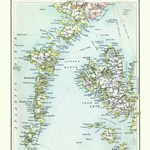
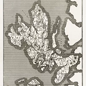
MAP: SCOTLAND, 1849. Map of Scotland. Engraving published by S. Augustus Mitchell
MAP: SCOTLAND, 1849.
Map of Scotland. Engraving published by S. Augustus Mitchell, 1849
Granger holds millions of images spanning more than 25,000 years of world history, from before the Stone Age to the dawn of the Space Age
Media ID 13637026
1849 Atlantic Ocean Augustus Hebrides Mitchell North Sea Scotland Scottish Isle Of Skye Orkney Islands Shetland Islands
10"x8" Photo Print
Travel back in time with our vintage Map of Scotland print from The Granger Collection. This beautiful engraving, published by S. Augustus Mitchell in 1849, offers a fascinating glimpse into the historical geography of Scotland. Add an air of antiquity and charm to your home or office with this exquisite piece from our Media Storehouse range of Photographic Prints. Order now and let history come alive in your space.
Photo prints are produced on Kodak professional photo paper resulting in timeless and breath-taking prints which are also ideal for framing. The colors produced are rich and vivid, with accurate blacks and pristine whites, resulting in prints that are truly timeless and magnificent. Whether you're looking to display your prints in your home, office, or gallery, our range of photographic prints are sure to impress. Dimensions refers to the size of the paper in inches.
Our Photo Prints are in a large range of sizes and are printed on Archival Quality Paper for excellent colour reproduction and longevity. They are ideal for framing (our Framed Prints use these) at a reasonable cost. Alternatives include cheaper Poster Prints and higher quality Fine Art Paper, the choice of which is largely dependant on your budget.
Estimated Product Size is 20.3cm x 25.4cm (8" x 10")
These are individually made so all sizes are approximate
Artwork printed orientated as per the preview above, with portrait (vertical) orientation to match the source image.
EDITORS COMMENTS
This print showcases a historical map of Scotland from the year 1849. The intricate engraving, published by S. Augustus Mitchell, provides a detailed representation of the Scottish landscape during that era. The map encompasses various significant locations such as the Hebrides, Isle of Skye, Orkney Islands, and Shetland Islands. The artist's attention to detail is evident in this piece, with each region clearly labeled and accompanied by descriptive text. As we gaze upon this vintage map, it transports us back in time to an age when cartography was both an art form and a means of navigation. The coastal areas are particularly striking on this map; the Atlantic Ocean stretches out towards the west while the North Sea borders Scotland's eastern shores. These bodies of water played crucial roles in shaping Scotland's history and culture. Whether you have ancestral ties to Scotland or simply appreciate its rich heritage, this print offers a unique glimpse into its past. Hang it proudly on your wall as a conversation starter or use it as inspiration for planning your next adventure through these historic lands.
MADE IN THE USA
Safe Shipping with 30 Day Money Back Guarantee
FREE PERSONALISATION*
We are proud to offer a range of customisation features including Personalised Captions, Color Filters and Picture Zoom Tools
SECURE PAYMENTS
We happily accept a wide range of payment options so you can pay for the things you need in the way that is most convenient for you
* Options may vary by product and licensing agreement. Zoomed Pictures can be adjusted in the Cart.