Photographic Print > Historic > Colonial America illustrations > Colonial America
Photographic Print : VIRGINIA: MAP, 1738. Map of colonial Virginia. Line engraving after a drawing of 1738

![]()
Photo Prints from Granger
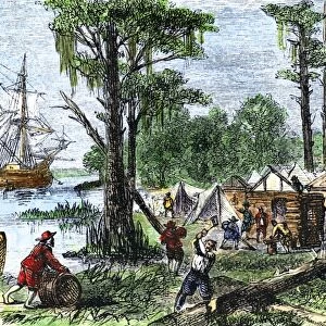
VIRGINIA: MAP, 1738. Map of colonial Virginia. Line engraving after a drawing of 1738
VIRGINIA: MAP, 1738.
Map of colonial Virginia. Line engraving after a drawing of 1738
Granger holds millions of images spanning more than 25,000 years of world history, from before the Stone Age to the dawn of the Space Age
Media ID 12319783
1738 Colonial Commonwealth United States Virginia Southeast
12"x8" Photo Print
Discover the rich history of colonial Virginia with our exquisite, museum-quality photographic print from Media Storehouse. This captivating image, titled "VIRGINIA: MAP, 1738," is a line engraving after a drawing from 1738, held in The Granger Collection at Granger Art on Demand. Transport yourself back in time as you explore the intricate details of this historical map, showcasing the layout of Virginia during its colonial era. A perfect addition to your home or office, this photographic print is a beautiful representation of American history and an excellent conversation starter. Bring the past to life with Media Storehouse.
Photo prints are produced on Kodak professional photo paper resulting in timeless and breath-taking prints which are also ideal for framing. The colors produced are rich and vivid, with accurate blacks and pristine whites, resulting in prints that are truly timeless and magnificent. Whether you're looking to display your prints in your home, office, or gallery, our range of photographic prints are sure to impress. Dimensions refers to the size of the paper in inches.
Our Photo Prints are in a large range of sizes and are printed on Archival Quality Paper for excellent colour reproduction and longevity. They are ideal for framing (our Framed Prints use these) at a reasonable cost. Alternatives include cheaper Poster Prints and higher quality Fine Art Paper, the choice of which is largely dependant on your budget.
Estimated Image Size (if not cropped) is 30.4cm x 18.1cm (12" x 7.1")
Estimated Product Size is 30.5cm x 20.3cm (12" x 8")
These are individually made so all sizes are approximate
Artwork printed orientated as per the preview above, with landscape (horizontal) orientation to match the source image.
FEATURES IN THESE COLLECTIONS
> Granger Art on Demand
> Maps
> Historic
> Colonial America illustrations
> Colonial America
> Maps and Charts
> Early Maps
> Maps and Charts
> Related Images
EDITORS COMMENTS
This print takes us back to the year 1738, offering a glimpse into the colonial era of Virginia. The intricate map showcases the vastness and beauty of this southeastern state in the United States. Created through line engraving after a drawing from that very same year, it is evident that great care and precision were put into capturing every detail. As we study this historical artifact, we are transported to a time when America was still in its infancy. The map reveals the early layout of settlements, rivers, and natural features that shaped Virginia's landscape during this period. It serves as a testament to the pioneering spirit of those who ventured into these uncharted territories. The Granger Collection has masterfully preserved this piece of history for our appreciation today. Its inclusion in their Carousel Collection highlights its significance among other remarkable works of art. With each glance at this print, one can't help but feel connected to Virginia's rich past as a colonial commonwealth. It sparks curiosity about how life must have been like for those who called this land home centuries ago. Whether you are an American history enthusiast or simply appreciate fine craftsmanship, "VIRGINIA: MAP, 1738" is sure to captivate your imagination and transport you on an unforgettable journey through time.
MADE IN THE USA
Safe Shipping with 30 Day Money Back Guarantee
FREE PERSONALISATION*
We are proud to offer a range of customisation features including Personalised Captions, Color Filters and Picture Zoom Tools
SECURE PAYMENTS
We happily accept a wide range of payment options so you can pay for the things you need in the way that is most convenient for you
* Options may vary by product and licensing agreement. Zoomed Pictures can be adjusted in the Cart.