Photographic Print > Africa > Gabon > Maps
Photographic Print : Map, Afrique Equatoriale; L'Ouest Africain, 1914. Creator: Unknown


![]()
Photo Prints from Heritage Images
Map, Afrique Equatoriale; L'Ouest Africain, 1914. Creator: Unknown
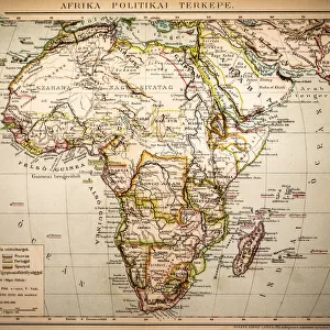
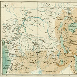
Map, Afrique Equatoriale; L'Ouest Africain, 1914. From "Grande Geographie Bong Illustree", 1914
Heritage Images features heritage image collections
Media ID 36295127
© The Print Collector/Heritage Images
Angola Belgian Belgian Congo Cameroon Cartography Central Africa Central African Colonies Colony Congo Equatorial Map Making Mapmaking Portugal Portuguese Rhodesia Africa Scramble For Africa Sudan
10"x8" Photo Print
Step back in time with our vintage Map Print from Media Storehouse, featuring "Afrique Equatoriale; L'Ouest Africain" from 1914. This intriguing map, sourced from the pages of Grande Geographie Bong Illustree, showcases the geography of Western Equatorial Africa during an era of significant historical change. Add an air of adventure and exploration to any room with this captivating, unknown creator, unknown piece. Perfect for history enthusiasts, cartography collectors, or those who appreciate the beauty of the past. Order now and let this map print transport you to another time.
Photo prints are produced on Kodak professional photo paper resulting in timeless and breath-taking prints which are also ideal for framing. The colors produced are rich and vivid, with accurate blacks and pristine whites, resulting in prints that are truly timeless and magnificent. Whether you're looking to display your prints in your home, office, or gallery, our range of photographic prints are sure to impress. Dimensions refers to the size of the paper in inches.
Our Photo Prints are in a large range of sizes and are printed on Archival Quality Paper for excellent colour reproduction and longevity. They are ideal for framing (our Framed Prints use these) at a reasonable cost. Alternatives include cheaper Poster Prints and higher quality Fine Art Paper, the choice of which is largely dependant on your budget.
Estimated Image Size (if not cropped) is 18.4cm x 25.4cm (7.2" x 10")
Estimated Product Size is 20.3cm x 25.4cm (8" x 10")
These are individually made so all sizes are approximate
Artwork printed orientated as per the preview above, with portrait (vertical) orientation to match the source image.
FEATURES IN THESE COLLECTIONS
> Africa
> Angola
> Related Images
> Africa
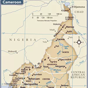
> Cameroon
> Related Images
> Africa
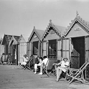
> Gabon
> Related Images
> Africa
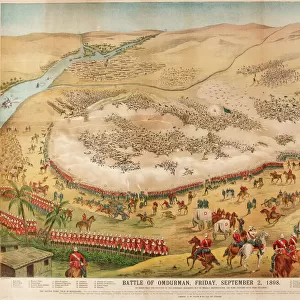
> Sudan
> Related Images
> Africa
> Zimbabwe
> Rhodesia
EDITORS COMMENTS
This map print, titled "Map, Afrique Equatoriale; L'Ouest Africain" and dated 1914, offers a fascinating glimpse into the colonial era of Africa. The map depicts the westernmost region of Central Africa, encompassing present-day Angola, Cameroon, Gabon, and parts of the Democratic Republic of the Congo, Central African Republic, Chad, and Sudan. The map was published in the renowned Belgian geography magazine "Grande Geographie Bong Illustree," indicating its origins in the Belgian colonial empire. The map is a testament to the intense competition and scramble for African territories during the late 19th and early 20th centuries. British, French, Belgian, Portuguese, and German colonies are clearly demarcated, reflecting the complex political landscape of the time. The map's intricate detailing and vibrant color palette make it an engaging representation of the geography and territorial claims during this period. The map's creation coincides with the height of European colonialism in Africa, as powers like Belgium, France, Britain, Portugal, and Germany sought to expand their empires and exert influence over the African continent. The map serves as a visual reminder of the historical significance of this era, which shaped the political, economic, and social landscape of Africa and the world at large. Despite the map's unknown creator, it remains an essential historical artifact, providing valuable insights into the geography and colonial history of Central Africa during the 1910s. Its inclusion in "Grande Geographie Bong Illustree" further underscores its importance as a significant piece of cartographic history.
MADE IN THE USA
Safe Shipping with 30 Day Money Back Guarantee
FREE PERSONALISATION*
We are proud to offer a range of customisation features including Personalised Captions, Color Filters and Picture Zoom Tools
SECURE PAYMENTS
We happily accept a wide range of payment options so you can pay for the things you need in the way that is most convenient for you
* Options may vary by product and licensing agreement. Zoomed Pictures can be adjusted in the Cart.