Photographic Print > Europe > United Kingdom > Scotland > Edinburgh > Edinburgh
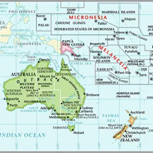
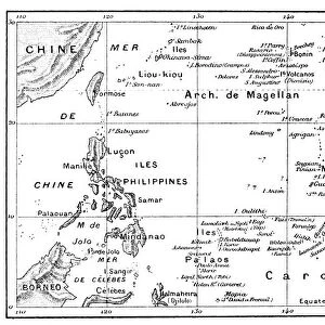
Photographic Print : Map of Oceania, 1902. Creator: Unknown


![]()
Photo Prints from Heritage Images
Map of Oceania, 1902. Creator: Unknown
Map of Oceania, 1902. Showing Australia and New Zealand, and the East Indies Archipelago. From The Century Atlas of the World. [John Walker & Co, Ltd. London, 1902]
Heritage Images features heritage image collections
Media ID 15512566
© The Print Collector / Heritage-Images
Archipelago Australia East Indies Edinburgh Geographical Institute Island Islands Micronesia New Zealand Oceania Pacific Ocean
10"x8" Photo Print
Step back in time with our vintage Map of Oceania print from Media Storehouse. This beautiful, historic map, created in 1902 by an unknown artist for The Century Atlas of the World, provides a fascinating glimpse into the geographical understanding of the world over a century ago. The map features detailed depictions of Australia, New Zealand, and the East Indies Archipelago, making it an intriguing addition to any home or office. With its rich heritage from Heritage Images, this print is not just a map, but a piece of history that tells a story. Bring the past into the present and add a touch of nostalgia to your space with our Map of Oceania print.
Photo prints are produced on Kodak professional photo paper resulting in timeless and breath-taking prints which are also ideal for framing. The colors produced are rich and vivid, with accurate blacks and pristine whites, resulting in prints that are truly timeless and magnificent. Whether you're looking to display your prints in your home, office, or gallery, our range of photographic prints are sure to impress. Dimensions refers to the size of the paper in inches.
Our Photo Prints are in a large range of sizes and are printed on Archival Quality Paper for excellent colour reproduction and longevity. They are ideal for framing (our Framed Prints use these) at a reasonable cost. Alternatives include cheaper Poster Prints and higher quality Fine Art Paper, the choice of which is largely dependant on your budget.
Estimated Product Size is 25.4cm x 20.3cm (10" x 8")
These are individually made so all sizes are approximate
Artwork printed orientated as per the preview above, with landscape (horizontal) or portrait (vertical) orientation to match the source image.
FEATURES IN THESE COLLECTIONS
> Arts
> Artists
> O
> Oceanic Oceanic
> Europe
> United Kingdom
> Scotland
> Edinburgh
> Edinburgh
> Europe
> United Kingdom
> Scotland
> Lothian
> Edinburgh
> Maps and Charts
> Related Images
> Maps and Charts
> World
> Oceania
> Federated States of Micronesia
> Maps
> Oceania
> New Zealand
> Maps
> Oceania
> New Zealand
> Related Images
EDITORS COMMENTS
This print showcases a remarkable piece of cartographic history - the "Map of Oceania, 1902". Created by an unknown artist and featured in The Century Atlas of the World, this map provides a fascinating glimpse into the geographical landscape of the early 20th century. The vibrant colors bring to life Australia and New Zealand, two prominent countries within Oceania, as well as the sprawling East Indies Archipelago. With meticulous detail, this map highlights various islands scattered across the Pacific Ocean, including Micronesia. As we delve into this visual treasure trove from John Walker & Co. , Ltd. in London, it becomes evident that every inch has been carefully crafted by experts at Edinburgh Geographical Institute. Their dedication to accuracy is apparent as they accurately depict each country's location and shape. Beyond its aesthetic appeal lies a wealth of historical significance. This map serves as a testament to human curiosity about our world and our desire to explore distant lands. It offers us a window into how people perceived geography over a century ago. Preserved by The Print Collector for future generations to admire, this exceptional print invites us on an enchanting journey through time and space. Whether you are an avid historian or simply captivated by beautiful artwork, this Map of Oceania will undoubtedly leave you awe-inspired with its intricate details and rich hues.
MADE IN THE USA
Safe Shipping with 30 Day Money Back Guarantee
FREE PERSONALISATION*
We are proud to offer a range of customisation features including Personalised Captions, Color Filters and Picture Zoom Tools
SECURE PAYMENTS
We happily accept a wide range of payment options so you can pay for the things you need in the way that is most convenient for you
* Options may vary by product and licensing agreement. Zoomed Pictures can be adjusted in the Cart.