Photographic Print > Europe > United Kingdom > Scotland > Edinburgh > Edinburgh
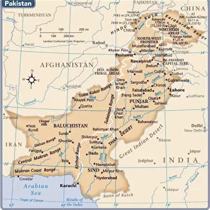
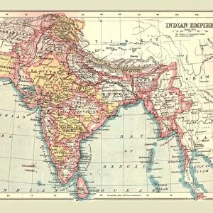
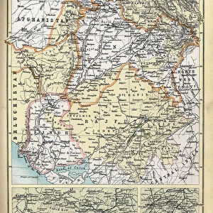
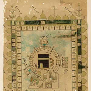
Photographic Print : Map of Punjab, Sind, Rajputana and Kashmir, 1902. Creator: Unknown


![]()
Photo Prints from Heritage Images
Map of Punjab, Sind, Rajputana and Kashmir, 1902. Creator: Unknown
Map of Punjab, Sind, Rajputana and Kashmir, 1902. From The Century Atlas of the World. [John Walker & Co, Ltd. London, 1902]
Heritage Images features heritage image collections
Media ID 15512578
© The Print Collector / Heritage-Images
British Raj Edinburgh Geographical Institute Kashmir Pakistan Punjab Rajasthan Rajpootana Rajputana Sindh The Raj British Empire Hindoostan
10"x8" Photo Print
Step back in time with our vintage Map of Punjab, Sind, Rajputana, and Kashmir from 1902, taken from The Century Atlas of the World by John Walker & Co, Ltd. London. This beautiful, antique print, created by an unknown artist, showcases the historical geography of the region during a time of great change. Add a touch of history and character to your home or office with this unique and intriguing piece from our Media Storehouse range of Photographic Prints. Each print is carefully preserved and printed on high-quality archival paper to ensure longevity and vibrant colors. Order yours today and travel back in time with every glance.
Photo prints are produced on Kodak professional photo paper resulting in timeless and breath-taking prints which are also ideal for framing. The colors produced are rich and vivid, with accurate blacks and pristine whites, resulting in prints that are truly timeless and magnificent. Whether you're looking to display your prints in your home, office, or gallery, our range of photographic prints are sure to impress. Dimensions refers to the size of the paper in inches.
Our Photo Prints are in a large range of sizes and are printed on Archival Quality Paper for excellent colour reproduction and longevity. They are ideal for framing (our Framed Prints use these) at a reasonable cost. Alternatives include cheaper Poster Prints and higher quality Fine Art Paper, the choice of which is largely dependant on your budget.
Estimated Product Size is 20.3cm x 25.4cm (8" x 10")
These are individually made so all sizes are approximate
Artwork printed orientated as per the preview above, with landscape (horizontal) or portrait (vertical) orientation to match the source image.
FEATURES IN THESE COLLECTIONS
> Asia
> India
> Related Images
> Asia
> Pakistan
> Related Images
> Europe
> United Kingdom
> Scotland
> Edinburgh
> Edinburgh
> Europe
> United Kingdom
> Scotland
> Lothian
> Edinburgh
> Maps and Charts
> British Empire Maps
> Maps and Charts
> India
> Maps and Charts
> Related Images
> Maps and Charts
> World
EDITORS COMMENTS
This print showcases a historical treasure, the "Map of Punjab, Sind, Rajputana and Kashmir" from 1902. With its vibrant colors and intricate details, this map takes us back to the era of the British Empire and their influence in India during the early 20th century. Created by an unknown cartographer for "The Century Atlas of the World" this map provides a fascinating glimpse into the geographical landscape of Hindoostan (India) at that time. It covers regions such as Punjab, Sind, Rajputana (Rajasthan), and Kashmir - areas that played significant roles in shaping Indian history. The craftsmanship displayed by Edinburgh Geographical Institute is evident in every stroke on this print. The precision with which they captured each boundary line and labeled every city demonstrates their commitment to accuracy. As we explore this map further, it becomes clear how crucial these regions were within the British Raj. From trade routes to political boundaries, everything was meticulously recorded here. This piece serves as a testament to both colonial power dynamics and cultural diversity within India. Preserved by The Print Collector, this image allows us to appreciate not only its historical significance but also its artistic beauty. Let's delve into this visual representation of a bygone era – where nations were defined by borders yet united through shared heritage – reminding ourselves of our collective past while embracing our diverse present.
MADE IN THE USA
Safe Shipping with 30 Day Money Back Guarantee
FREE PERSONALISATION*
We are proud to offer a range of customisation features including Personalised Captions, Color Filters and Picture Zoom Tools
SECURE PAYMENTS
We happily accept a wide range of payment options so you can pay for the things you need in the way that is most convenient for you
* Options may vary by product and licensing agreement. Zoomed Pictures can be adjusted in the Cart.