Photographic Print > Europe > United Kingdom > England > London > Transport > Railway
Photographic Print : Map showing the Scene of the German Attacks... First World War, February 1916, (c1920)
")

![]()
Photo Prints from Heritage Images
Map showing the Scene of the German Attacks... First World War, February 1916, (c1920)
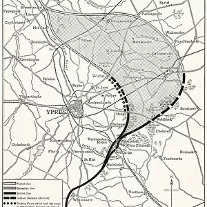
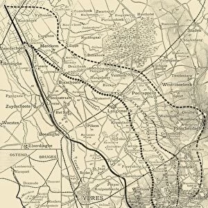
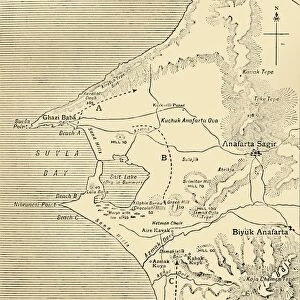
Map showing the Scene of the German Attacks East and South-east of Ypres, [Belgium], First World War, February 1916, (c1920). The " Bluff" and International Trench lie on the wooded hill north of the Ypres-Comines Canal and south of Hill 60. From " The Great World War: A History", Volume V, edited by Frank A Mumby. [The Gresham Publishing Company Ltd, London, c1920]
Heritage Images features heritage image collections
Media ID 19664842
© The Print Collector/Heritage Images
Canal Frank A Frank A Mumby Frank Arthur Frank Arthur Mumby Front Line Frontline Gresham Publishing Co Ltd Gresham Publishing Company Keystone Archives Mumby Mumby Frank A Mumby Frank Arthur The Great World War A History Theatre Of War Western Front Ypres Ypres Flanders Belgium Battle Of Ypres Battlefield
10"x10" Photo Print
Step back in time with our exclusive Media Storehouse photographic print, featuring an intriguing map from Heritage Images. This rare find dates back to the First World War era, around February 1916, and depicts the scene of German attacks east and south-east of Ypres, Belgium. The map provides a captivating insight into the strategic military movements during this pivotal period in history. Add this unique piece to your collection and bring a piece of historical significance into your home or office.
Photo prints are produced on Kodak professional photo paper resulting in timeless and breath-taking prints which are also ideal for framing. The colors produced are rich and vivid, with accurate blacks and pristine whites, resulting in prints that are truly timeless and magnificent. Whether you're looking to display your prints in your home, office, or gallery, our range of photographic prints are sure to impress. Dimensions refers to the size of the paper in inches.
Our Photo Prints are in a large range of sizes and are printed on Archival Quality Paper for excellent colour reproduction and longevity. They are ideal for framing (our Framed Prints use these) at a reasonable cost. Alternatives include cheaper Poster Prints and higher quality Fine Art Paper, the choice of which is largely dependant on your budget.
Estimated Product Size is 25.4cm x 25.4cm (10" x 10")
These are individually made so all sizes are approximate
Artwork printed orientated as per the preview above, with landscape (horizontal) or portrait (vertical) orientation to match the source image.
FEATURES IN THESE COLLECTIONS
> Europe
> Belgium
> Related Images
> Europe
> United Kingdom
> England
> London
> Art
> Theatre
> Europe
> United Kingdom
> England
> London
> Transport
> Railway
> Historic
> Battles
> Related Images
> Historic
> World War I and II
> Battlefields
> Historic
> World War I and II
EDITORS COMMENTS
This print captures a map showing the scene of the German attacks during the First World War in February 1916. The image, taken from "The Great World War: A History", edited by Frank A Mumby, provides a detailed overview of the battlefields near Ypres, Belgium. The map highlights significant locations such as the "Bluff" and International Trench situated on a wooded hill north of the Ypres-Comines Canal and south of Hill 60. The photograph offers a glimpse into the strategic importance of these areas during one of history's most devastating conflicts. It showcases how railways and water transport played crucial roles in supplying troops and resources to this theatre of war on the Western Front. Although we do not know who took this photograph or its exact purpose, it serves as a valuable historical document that allows us to visualize and understand the complexities faced by soldiers fighting in Flanders during WWI. The image also reminds us of the immense sacrifices made by those involved in this brutal battle. As we reflect upon this snapshot from our past, let us remember all those who fought bravely for their countries amidst unimaginable hardships. May their courage serve as an enduring reminder that peace is worth pursuing at all costs.
MADE IN THE USA
Safe Shipping with 30 Day Money Back Guarantee
FREE PERSONALISATION*
We are proud to offer a range of customisation features including Personalised Captions, Color Filters and Picture Zoom Tools
SECURE PAYMENTS
We happily accept a wide range of payment options so you can pay for the things you need in the way that is most convenient for you
* Options may vary by product and licensing agreement. Zoomed Pictures can be adjusted in the Cart.