Photographic Print > Europe > United Kingdom > England > London > Art > Theatre
Photographic Print : The Suvla and Anzac Line, First World War, August 1915, (c1920). Creator: Unknown
. Creator: Unknown")
![]()
Photo Prints from Heritage Images
The Suvla and Anzac Line, First World War, August 1915, (c1920). Creator: Unknown
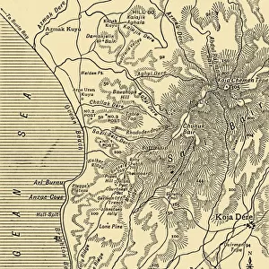
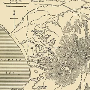
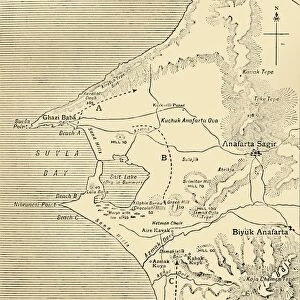
The Suvla and Anzac Line, First World War, August 1915, (c1920)....map showing approximately by the shaded portion the area occupied after the linking up of the two armies in August, 1915. The landing at Suvla Bay on the coast of the Gallipoli peninsula in Turkey was part of the August Offensive. The area was the scene of heavy fighting between the allied forces of the British Empire including Australia, and New Zealand (ANZACs), and the Turkish Ottoman Empire. From " The Great World War: A History", Volume V, edited by Frank A Mumby. [The Gresham Publishing Company Ltd, London, c1920]
Heritage Images features heritage image collections
Media ID 19665691
© The Print Collector/Heritage Images
Anzac Anzac Cove Anzacs Australian And New Zealand Army Corps Cove Dardanelles Campaign Frank A Frank A Mumby Frank Arthur Frank Arthur Mumby Front Line Frontline Gallipoli Campaign Gallipoli Peninsula Gallipoli Peninsula Turkey Gresham Publishing Co Ltd Gresham Publishing Company Keystone Archives Mumby Mumby Frank A Mumby Frank Arthur Occupied Territory Suvla Bay Territorial Territory The Great World War A History Theatre Of War Turkey Battlefield
12"x8" Photo Print
Step back in time with this historic photograph from the Media Storehouse collection, depicting The Suvla and Anzac Line during the First World War in August 1915. This rare image, taken around 1920, shows the approximate area where the two armies linked up, as indicated by the shaded portion on the map. A fascinating addition to any military history collection, this print brings the past to life with its intricate details and authenticity. Note: Creator and publisher information is unknown.
Photo prints are produced on Kodak professional photo paper resulting in timeless and breath-taking prints which are also ideal for framing. The colors produced are rich and vivid, with accurate blacks and pristine whites, resulting in prints that are truly timeless and magnificent. Whether you're looking to display your prints in your home, office, or gallery, our range of photographic prints are sure to impress. Dimensions refers to the size of the paper in inches.
Our Photo Prints are in a large range of sizes and are printed on Archival Quality Paper for excellent colour reproduction and longevity. They are ideal for framing (our Framed Prints use these) at a reasonable cost. Alternatives include cheaper Poster Prints and higher quality Fine Art Paper, the choice of which is largely dependant on your budget.
Estimated Image Size (if not cropped) is 17.3cm x 30.4cm (6.8" x 12")
Estimated Product Size is 20.3cm x 30.5cm (8" x 12")
These are individually made so all sizes are approximate
Artwork printed orientated as per the preview above, with portrait (vertical) orientation to match the source image.
FEATURES IN THESE COLLECTIONS
> Asia
> Turkey
> Related Images
> Europe
> United Kingdom
> England
> London
> Art
> Theatre
> Historic
> World War I and II
> Battlefields
> Historic
> World War I and II
> World War I
> Historic
> World War I and II
> Maps and Charts
> British Empire Maps
> Maps and Charts
> Related Images
EDITORS COMMENTS
This print titled "The Suvla and Anzac Line, First World War, August 1915" captures a crucial moment in history. The image is a map showing the area occupied after the linking up of two armies during the Gallipoli campaign in Turkey. It was part of the larger August Offensive that saw intense fighting between allied forces from the British Empire, including Australia and New Zealand (ANZACs), against the Turkish Ottoman Empire. The photograph provides a glimpse into the harsh realities faced by soldiers on both sides during this brutal conflict. The shaded portion on the map represents the territory gained through great sacrifice and determination. This visual documentation serves as a testament to their bravery and resilience amidst unimaginable conditions. Taken from "The Great World War: A History" edited by Frank A Mumby, this print offers historical significance for those interested in understanding one of humanity's most devastating conflicts. While its creator remains unknown, its value lies in preserving an important chapter of our collective past. As we reflect upon this image, let us remember all those who fought bravely on these battlefields - their sacrifices forever etched into history. May it serve as a reminder to cherish peace and strive for harmony among nations today.
MADE IN THE USA
Safe Shipping with 30 Day Money Back Guarantee
FREE PERSONALISATION*
We are proud to offer a range of customisation features including Personalised Captions, Color Filters and Picture Zoom Tools
SECURE PAYMENTS
We happily accept a wide range of payment options so you can pay for the things you need in the way that is most convenient for you
* Options may vary by product and licensing agreement. Zoomed Pictures can be adjusted in the Cart.