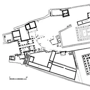
Photographic Print > Historic > Ancient civilizations > Ancient Greece > Athens
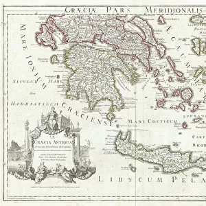
Photographic Print : 1784, Bocage Map of the City of Athens in Ancient Greece, topography, cartography


![]()
Photo Prints from Liszt Collection
1784, Bocage Map of the City of Athens in Ancient Greece, topography, cartography
1784, Bocage Map of the City of Athens in Ancient Greece
Liszt Collection of nineteenth-century engravings and images to browse and enjoy
Media ID 14006840
© Artokoloro Quint Lox Limited
1784 Antique Map Latitude Longitude Mappa Mundi Old Antique Plan Old Antique View Ols Antique Map Rare Old Maps Topo
10"x8" Photo Print
Discover the rich history of Ancient Greece with our exquisite Media Storehouse Photographic Print of the 1784 Bocage Map of the City of Athens. This rare and captivating map, part of the esteemed Liszt Collection, offers a unique glimpse into ancient cartography. Meticulously preserved and beautifully rendered in high-resolution, this print transports you back in time, allowing you to explore the topography of Athens as it was known over 230 years ago. A stunning addition to any home or office, this photographic print makes for an extraordinary conversation piece and a treasured piece of historical art.
Photo prints are produced on Kodak professional photo paper resulting in timeless and breath-taking prints which are also ideal for framing. The colors produced are rich and vivid, with accurate blacks and pristine whites, resulting in prints that are truly timeless and magnificent. Whether you're looking to display your prints in your home, office, or gallery, our range of photographic prints are sure to impress. Dimensions refers to the size of the paper in inches.
Our Photo Prints are in a large range of sizes and are printed on Archival Quality Paper for excellent colour reproduction and longevity. They are ideal for framing (our Framed Prints use these) at a reasonable cost. Alternatives include cheaper Poster Prints and higher quality Fine Art Paper, the choice of which is largely dependant on your budget.
Estimated Product Size is 25.4cm x 20.3cm (10" x 8")
These are individually made so all sizes are approximate
Artwork printed orientated as per the preview above, with landscape (horizontal) orientation to match the source image.
FEATURES IN THESE COLLECTIONS
> Europe
> France
> Canton
> Landes
> Europe
> Greece
> Related Images
> Historic
> Ancient civilizations
> Ancient Greece
> Athens
> Historic
> Ancient civilizations
> Ancient Greece
> Greek history
> Historic
> Space exploration
> Maps and Charts
> Early Maps
EDITORS COMMENTS
This print showcases the exquisite 1784 Bocage Map of the City of Athens in Ancient Greece. A true masterpiece in topography and cartography, this vintage map offers a fascinating glimpse into the ancient world. With its intricate details and precise measurements, it serves as a valuable historical artifact that transports us back to a time long gone. The artistry behind this map is truly remarkable. Every contour, every street, and every landmark is meticulously illustrated with stunning accuracy. Its delicate lines form an intricate grid of latitude and longitude, allowing viewers to navigate through the city's rich history effortlessly. As we gaze upon this aged piece of art, we are reminded of the countless journeys and discoveries made by explorers who once relied on such maps for navigation. It evokes a sense of wonderment about our planet's past and ignites our curiosity about civilizations that thrived centuries ago. With its decorative appeal, this antique map adds a touch of elegance to any space it graces. Whether displayed in a study or framed on a wall, it becomes both an educational tool and an object d'art that sparks conversations about ancient cultures. The Liszt Collection has preserved this rare gem from history for all to admire—a testament to their dedication in safeguarding our collective heritage.
MADE IN THE USA
Safe Shipping with 30 Day Money Back Guarantee
FREE PERSONALISATION*
We are proud to offer a range of customisation features including Personalised Captions, Color Filters and Picture Zoom Tools
SECURE PAYMENTS
We happily accept a wide range of payment options so you can pay for the things you need in the way that is most convenient for you
* Options may vary by product and licensing agreement. Zoomed Pictures can be adjusted in the Cart.