Photographic Print > Arts > Artists > H > Jodocus Hondius
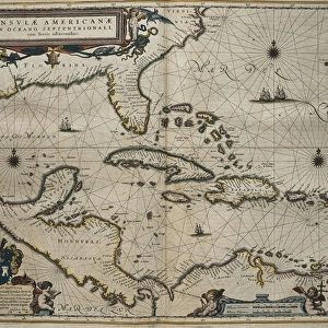
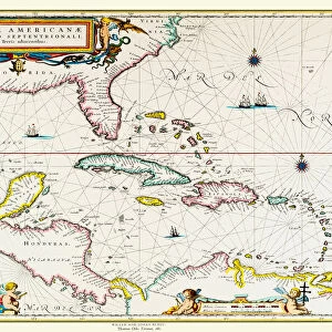
Photographic Print : Old Map of The West Indies 1662 by Willem & Johan Blaue from the Theatrum Orbis Terrarum


![]()
Photo Prints from MapSeeker
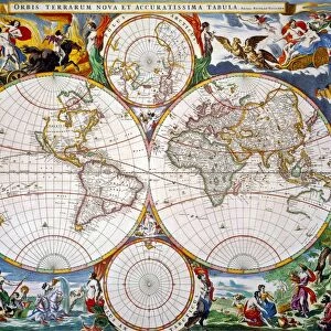
Old Map of The West Indies 1662 by Willem & Johan Blaue from the Theatrum Orbis Terrarum
This detailed and most attractive reproduction map of The West Indies has been carefully art worked from a scan of an antique original. The famous firm of Dutch cartographers and publishers was established in the late 16th century by Willem Janszoon Blaeu in Amsterdam. Blaeu was a maker of globes and scientific instruments and purchased some of his early map plates from Jodocus Hondius. From this small beginning was to emerge one of the largest and most prolific map publishing houses of the seventeenth century
Welcome to the Mapseeker Image library and enter an historic gateway to one of the largest on-line collections of Historic Maps, Nostalgic Views, Vista's and Panorama's from a World gone by.
Media ID 20347711
Blaeu Blaeu Family Blaue Map Historic Map Johan Blaeu Johan Blaeu Map Old Blaue Map
11"x8.5" Photo Print
Discover history with our exquisite reproduction of the Old Map of The West Indies, dated 1662. This magnificent piece, brought to you by Media Storehouse in collaboration with MapSeeker, is meticulously crafted from a scan of an original antique map created by Willem & Johan Blaue from Theatrum Orbis Terrarum. Immerse yourself in the intricate details of this beautifully preserved map, showcasing the West Indies as it once was. A perfect addition to any historical or cartography enthusiast's collection, or an elegant and thoughtful gift. Experience the past like never before with our high-quality photographic print.
Photo prints are produced on Kodak professional photo paper resulting in timeless and breath-taking prints which are also ideal for framing. The colors produced are rich and vivid, with accurate blacks and pristine whites, resulting in prints that are truly timeless and magnificent. Whether you're looking to display your prints in your home, office, or gallery, our range of photographic prints are sure to impress. Dimensions refers to the size of the paper in inches.
Our Photo Prints are in a large range of sizes and are printed on Archival Quality Paper for excellent colour reproduction and longevity. They are ideal for framing (our Framed Prints use these) at a reasonable cost. Alternatives include cheaper Poster Prints and higher quality Fine Art Paper, the choice of which is largely dependant on your budget.
Estimated Image Size (if not cropped) is 27.9cm x 18.6cm (11" x 7.3")
Estimated Product Size is 27.9cm x 21.6cm (11" x 8.5")
These are individually made so all sizes are approximate
Artwork printed orientated as per the preview above, with landscape (horizontal) orientation to match the source image.
FEATURES IN THESE COLLECTIONS
> MapSeeker
> Maps of the Americas
> Maps of Central and South America
> Arts
> Artists
> B
> Willem Blaeu
> Arts
> Artists
> H
> Jodocus Hondius
> Arts
> Photorealistic artworks
> Detailed art pieces
> Masterful detailing in art
> Maps and Charts
> Early Maps
> Maps and Charts
> Related Images
> Maps and Charts
> Willem Janszoon Blaeu
EDITORS COMMENTS
This stunning print showcases the "Old Map of The West Indies 1662" by Willem & Johan Blaue, taken from the renowned Theatrum Orbis Terrarum. Carefully reproduced from an antique original, this detailed and visually captivating map offers a glimpse into the rich history of the West Indies. The Blaeu family, famous Dutch cartographers and publishers, established their firm in Amsterdam during the late 16th century. Initially specializing in globes and scientific instruments, they soon expanded their repertoire to include map publishing. Willem Janszoon Blaeu, the founder of this esteemed company, acquired some of his earliest map plates from Jodocus Hondius. From these humble beginnings grew one of the largest and most prolific map publishing houses of the seventeenth century. This particular reproduction captures not only the expertise but also the artistry that made Blaeu's maps highly sought after. With its intricate details and exquisite craftsmanship, this historic map provides a fascinating insight into how our understanding of geography has evolved over time. It transports us back to a bygone era when exploration was at its peak and navigators charted new territories with great curiosity. Whether you are an avid collector or simply appreciate historical artifacts, this old map is sure to captivate your imagination as it unveils centuries-old secrets about the islands that comprise today's West Indies.
MADE IN THE USA
Safe Shipping with 30 Day Money Back Guarantee
FREE PERSONALISATION*
We are proud to offer a range of customisation features including Personalised Captions, Color Filters and Picture Zoom Tools
SECURE PAYMENTS
We happily accept a wide range of payment options so you can pay for the things you need in the way that is most convenient for you
* Options may vary by product and licensing agreement. Zoomed Pictures can be adjusted in the Cart.