Photographic Print > Arts > Artists > H > Jodocus Hondius
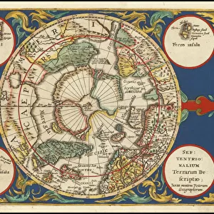
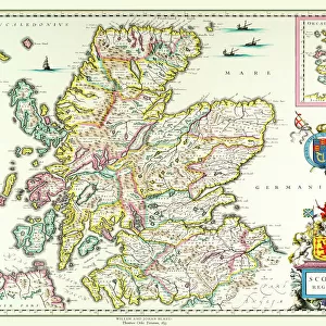
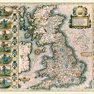
Photographic Print : Old Map of The British Isles 1635 by Willem & Johan Blaeu from the Theatrum Orbis Terrarum

![]()
Photo Prints from MapSeeker
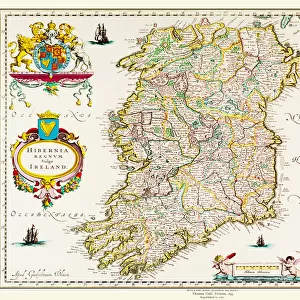
Old Map of The British Isles 1635 by Willem & Johan Blaeu from the Theatrum Orbis Terrarum
This detailed and most attractive reproduction map of The British Isles has been carefully art worked from a scan of an antique original. The famous firm of Dutch cartographers and publishers was established in the late 16th century by Willem Janszoon Blaeu in Amsterdam. Blaeu was a maker of globes and scientific instruments and purchased some of his early map plates from Jodocus Hondius. From this small beginning was to emerge one of the largest and most prolific map publishing houses of the seventeenth century
Welcome to the Mapseeker Image library and enter an historic gateway to one of the largest on-line collections of Historic Maps, Nostalgic Views, Vista's and Panorama's from a World gone by.
Media ID 20348005
Blaeu Blaeu Family Blaue Map Historic Map Johan Blaeu Johan Blaeu Map Old Blaue Map British Isles
12"x8" Photo Print
Discover history through the lens of time with Media Storehouse's Old Map of The British Isles 1635. This captivating reproduction, taken from Willem & Johan Blaeu's Theatrum Orbis Terrarum, showcases intricate details of the British Isles as they appeared over 400 years ago. Meticulously art-worked from a high-resolution scan of an original antique map, this photographic print brings the past to life. Travel back in time and adorn your walls with this exquisite piece of cartographic history. Experience the rich heritage of mapmaking and add a touch of nostalgia to your decor. Order yours today and let the stories of the past unfold before your eyes.
Photo prints are produced on Kodak professional photo paper resulting in timeless and breath-taking prints which are also ideal for framing. The colors produced are rich and vivid, with accurate blacks and pristine whites, resulting in prints that are truly timeless and magnificent. Whether you're looking to display your prints in your home, office, or gallery, our range of photographic prints are sure to impress. Dimensions refers to the size of the paper in inches.
Our Photo Prints are in a large range of sizes and are printed on Archival Quality Paper for excellent colour reproduction and longevity. They are ideal for framing (our Framed Prints use these) at a reasonable cost. Alternatives include cheaper Poster Prints and higher quality Fine Art Paper, the choice of which is largely dependant on your budget.
Estimated Product Size is 30.5cm x 20.3cm (12" x 8")
These are individually made so all sizes are approximate
Artwork printed orientated as per the preview above, with landscape (horizontal) orientation to match the source image.
FEATURES IN THESE COLLECTIONS
> MapSeeker
> Maps from the British Isles
> British Isles Map PORTFOLIO
> Arts
> Artists
> B
> Willem Blaeu
> Arts
> Artists
> H
> Jodocus Hondius
> Arts
> Photorealistic artworks
> Detailed art pieces
> Masterful detailing in art
> Maps and Charts
> Early Maps
> Maps and Charts
> Willem Janszoon Blaeu
EDITORS COMMENTS
This beautifully crafted reproduction of the "Old Map of The British Isles 1635" by Willem & Johan Blaeu takes us back in time to the rich history and intricate cartography of the seventeenth century. Carefully art worked from a scan of an antique original, this detailed map showcases the expertise and craftsmanship that made the Blaeu family one of the most renowned cartographers and publishers of their time. Established by Willem Janszoon Blaeu in Amsterdam, this Dutch firm initially specialized in globe-making and scientific instruments before venturing into map publishing. Acquiring some map plates from Jodocus Hondius, they laid the foundation for what would become a prolific map publishing house during the seventeenth century. The historic significance of this particular map lies in its depiction of The British Isles, offering a glimpse into how these lands were perceived over three centuries ago. With intricate details capturing coastlines, cities, rivers, and topographical features, it provides valuable insights into both geographical knowledge and artistic representation at that time. Whether you are a history enthusiast or simply appreciate fine craftsmanship, this reproduction allows you to admire an old-world treasure right at your fingertips. Let yourself be transported to an era where maps were not only practical tools but also works of art that ignited curiosity about distant lands.
MADE IN THE USA
Safe Shipping with 30 Day Money Back Guarantee
FREE PERSONALISATION*
We are proud to offer a range of customisation features including Personalised Captions, Color Filters and Picture Zoom Tools
SECURE PAYMENTS
We happily accept a wide range of payment options so you can pay for the things you need in the way that is most convenient for you
* Options may vary by product and licensing agreement. Zoomed Pictures can be adjusted in the Cart.