Photographic Print > Europe > United Kingdom > England > London > Towns > Welling
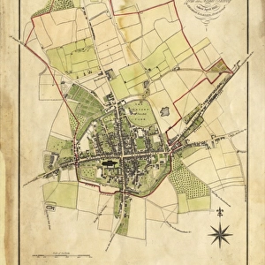
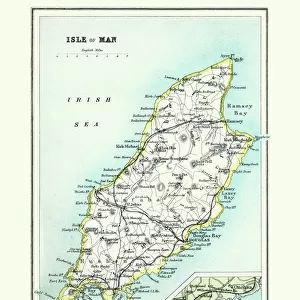
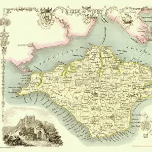
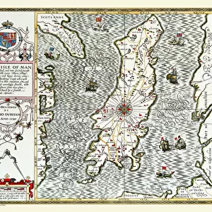
Photographic Print : Old Map of The Isle of Man 1836 by Thomas Moule


![]()
Photo Prints from MapSeeker
Old Map of The Isle of Man 1836 by Thomas Moule
This is a fine decorative reproduction Map of The Isle of Man from the First Edition series of Thomas Moule Maps, originally Published in 1836. The well-known series of County Maps which are known as Moules feature beautiful vignette views and were first published in separate sections for each county in 1830-32, they were then published in collected form in a two-volume work: The English Counties Delineated: or a Topographical Description of England: Illustrated by a Complete Series of County Maps by Thomas Moule: London: Published by George Virtue 1836
Welcome to the Mapseeker Image library and enter an historic gateway to one of the largest on-line collections of Historic Maps, Nostalgic Views, Vista's and Panorama's from a World gone by.
Media ID 20347905
© Mapseeker Publishing Ltd
Historic Map Moule Map Old Moule Map Thomas Moule Thomas Moule Map Isle Of Man
10"x8" Photo Print
Introducing the exquisite Old Map of The Isle of Man 1836 by Thomas Moule, a fine decorative reproduction from the esteemed First Edition series. This captivating map, published originally in 1836, is a masterpiece by Thomas Moule and George Virtue, as part of the extensive MapSeeker collection. Delve into the rich history of The Isle of Man with this intricately detailed map, which showcases the island's historical landmarks, settlements, and geographical features as they appeared over 180 years ago. The Old Map of The Isle of Man 1836 by Thomas Moule is not just a map; it is a time capsule, a window into the past, and a beautiful addition to any home or office. This decorative reproduction is meticulously crafted to preserve the original's intricate details and authentic color palette, ensuring that the essence of Thomas Moule's masterpiece is captured in every inch. Add a touch of historical charm to your space with this stunning Old Map of The Isle of Man 1836 by Thomas Moule – a timeless piece that celebrates the island's rich heritage.
Photo prints are produced on Kodak professional photo paper resulting in timeless and breath-taking prints which are also ideal for framing. The colors produced are rich and vivid, with accurate blacks and pristine whites, resulting in prints that are truly timeless and magnificent. Whether you're looking to display your prints in your home, office, or gallery, our range of photographic prints are sure to impress. Dimensions refers to the size of the paper in inches.
Our Photo Prints are in a large range of sizes and are printed on Archival Quality Paper for excellent colour reproduction and longevity. They are ideal for framing (our Framed Prints use these) at a reasonable cost. Alternatives include cheaper Poster Prints and higher quality Fine Art Paper, the choice of which is largely dependant on your budget.
Estimated Product Size is 25.4cm x 20.3cm (10" x 8")
These are individually made so all sizes are approximate
Artwork printed orientated as per the preview above, with landscape (horizontal) or portrait (vertical) orientation to match the source image.
FEATURES IN THESE COLLECTIONS
> MapSeeker
> Maps from the British Isles
> Islands around Britain PORTFOLIO
> Arts
> Artists
> M
> Thomas Moule
> Europe
> United Kingdom
> England
> London
> Towns
> Welling
> Europe
> United Kingdom
> England
> Maps
> Europe
> United Kingdom
> England
> Wells
> Maps and Charts
> Early Maps
> Maps and Charts
> Related Images
EDITORS COMMENTS
This exquisite print showcases the "Old Map of The Isle of Man 1836" by the renowned cartographer Thomas Moule. Originally published in 1836 as part of his esteemed series, this decorative reproduction captures the historical charm and intricate details that make Moule's maps so highly sought after. Moule's County Maps, also known as Moules, are celebrated for their captivating vignette views and were initially released individually for each county between 1830-32. This particular map is from a two-volume collection titled "The English Counties Delineated: or a Topographical Description of England" which was published in 1836 by George Virtue in London. As you gaze upon this historic treasure, you'll be transported back to a time when the Isle of Man was depicted with elegance and precision. Every contour, river, and settlement has been meticulously rendered on this piece of artistry. Whether you're an avid historian or simply appreciate vintage aesthetics, this old map offers a fascinating glimpse into the past. Displaying this stunning reproduction will not only add character to any space but also serve as a conversation starter about the rich history and allure of the Isle of Man. Let yourself be captivated by its timeless beauty and immerse yourself in an era long gone but forever preserved within these delicate lines crafted by Thomas Moule under George Virtue's watchful eye.
MADE IN THE USA
Safe Shipping with 30 Day Money Back Guarantee
FREE PERSONALISATION*
We are proud to offer a range of customisation features including Personalised Captions, Color Filters and Picture Zoom Tools
SECURE PAYMENTS
We happily accept a wide range of payment options so you can pay for the things you need in the way that is most convenient for you
* Options may vary by product and licensing agreement. Zoomed Pictures can be adjusted in the Cart.