Photographic Print > Arts > Photorealistic artworks > Meticulous attention to detail > Detailed artwork
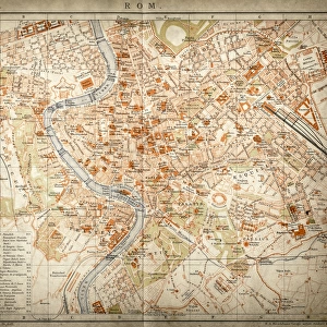
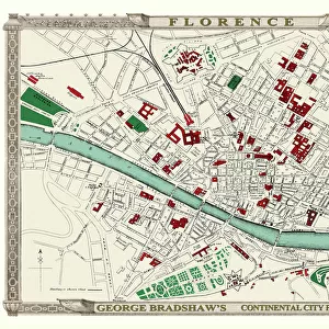
Photographic Print : George Bradshaws Plan of Rome, Italy 1896


![]()
Photo Prints from MapSeeker
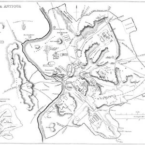
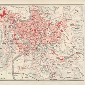
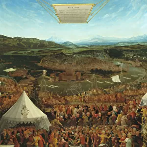
George Bradshaws Plan of Rome, Italy 1896
This is a very detailed Plan of Rome showing the streets, canals, principal buildings, railways and railway stations, as well as the many ancient Roman sites. A comprehensive list of 69 sites of interest are numbered and referenced to the plan, that include the Pantheon, Circus Maximus, Colossium and the Vatican. The plan has been meticulously recreated in colour and republished without and fold creases by Mapseeker, from a rare antique original black and white fold up tourist city map. The 29 that were originally published as fold up maps featuring the principal cities of Europe are now rare, yet popular at their time among those who could then explore Europe by railway for the first time
Welcome to the Mapseeker Image library and enter an historic gateway to one of the largest on-line collections of Historic Maps, Nostalgic Views, Vista's and Panorama's from a World gone by.
Media ID 20347981
© Mapseeker Publishing Ltd
Bradshaw City Map Bradshaw City Plan Bradshaw Map Europe City Europe City Plan European City Map European City Plan Historic Map Old Town Plan Italian City
11"x8.5" Photo Print
Discover the rich history of Rome with our exquisite photographic print of George Bradshaw's Plan of Rome, Italy, 1896. Meticulously reproduced from the original MapSeeker Publishing Ltd map, this captivating print showcases an intricately detailed representation of the Eternal City. Delve into the labyrinthine streets, canals, and ancient Roman sites, including principal buildings, railways, and railway stations. Transport yourself back in time and adorn your walls with this stunning piece of cartographical history.
Photo prints are produced on Kodak professional photo paper resulting in timeless and breath-taking prints which are also ideal for framing. The colors produced are rich and vivid, with accurate blacks and pristine whites, resulting in prints that are truly timeless and magnificent. Whether you're looking to display your prints in your home, office, or gallery, our range of photographic prints are sure to impress. Dimensions refers to the size of the paper in inches.
Our Photo Prints are in a large range of sizes and are printed on Archival Quality Paper for excellent colour reproduction and longevity. They are ideal for framing (our Framed Prints use these) at a reasonable cost. Alternatives include cheaper Poster Prints and higher quality Fine Art Paper, the choice of which is largely dependant on your budget.
Estimated Image Size (if not cropped) is 27.9cm x 18.6cm (11" x 7.3")
Estimated Product Size is 27.9cm x 21.6cm (11" x 8.5")
These are individually made so all sizes are approximate
Artwork printed orientated as per the preview above, with landscape (horizontal) orientation to match the source image.
FEATURES IN THESE COLLECTIONS
> MapSeeker
> Maps of Europe
> Maps of Italy PORTFOLIO
> Animals
> Mammals
> Muridae
> Maximus
> Arts
> Artists
> W
> George White
> Arts
> Modern art pieces
> Pop art
> Street art
> Arts
> Photorealistic artworks
> Detailed art pieces
> Masterful detailing in art
> Arts
> Photorealistic artworks
> Meticulous attention to detail
> Detailed artwork
> Arts
> Photorealistic artworks
> Meticulous attention to detail
> Fine art
> Europe
> Italy
> Lazio
> Rome
EDITORS COMMENTS
This stunning print showcases George Bradshaw's meticulously detailed Plan of Rome from 1896. The map provides a comprehensive view of the city, highlighting its intricate network of streets, canals, principal buildings, railways, and railway stations. What sets this plan apart is its inclusion of numerous ancient Roman sites that have shaped the city's rich history. The vibrant colors used in this reproduction bring new life to an original black and white fold-up tourist map. MapSeeker Publishing Ltd has taken great care to ensure that there are no fold creases on this republished version. This particular edition is part of a rare collection that originally featured 29 fold-up maps showcasing Europe's principal cities during a time when railway travel was revolutionizing exploration. The Plan of Rome serves as an invaluable resource for those interested in delving into the wonders of this iconic city. With 69 numbered sites of interest referenced directly on the plan, visitors can easily locate renowned landmarks such as the Pantheon, Circus Maximus, Colosseum, and even Vatican City. Whether you're a history enthusiast or simply fascinated by cartography, this old town plan offers a captivating glimpse into Rome's past. It not only captures the essence of one European city but also represents an era when rail travel opened up new possibilities for adventure across the continent.
MADE IN THE USA
Safe Shipping with 30 Day Money Back Guarantee
FREE PERSONALISATION*
We are proud to offer a range of customisation features including Personalised Captions, Color Filters and Picture Zoom Tools
SECURE PAYMENTS
We happily accept a wide range of payment options so you can pay for the things you need in the way that is most convenient for you
* Options may vary by product and licensing agreement. Zoomed Pictures can be adjusted in the Cart.