Photographic Print > Europe > Russia > Maps
Photographic Print : Daily Mail War Map, WW1

![]()
Photo Prints from Mary Evans Picture Library
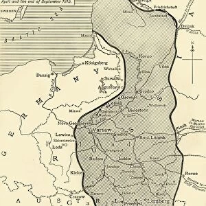
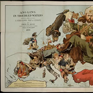
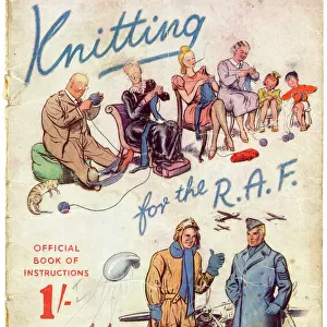
Daily Mail War Map, WW1
Front cover of a fold out war map issued by the Daily Mail in the early weeks of the First World War. On the cover, and inside, the map offers statistics regarding the manpower strength of each of the warring nations. While the Triple Entente of Britain, France and Russia could boast 9, 380, 000 men (of which Britain comprised just 380, 000), the Triple Alliance numbered 9, 500, 000. The map was intended to be marked with Philips flag pins in ten different colours so that civilians could chart the progress of the campaign. Date: 1914
Mary Evans Picture Library makes available wonderful images created for people to enjoy over the centuries
Media ID 14185848
© Mary Evans Picture Library
Alliance Covers Daily Entente Fold Mail Manpower Maps Statistics Strength Triple
11"x8.5" Photo Print
Step back in time with our exclusive Media Storehouse range of Photographic Prints featuring the Daily Mail War Map from the early weeks of the First World War. This captivating print, sourced from Mary Evans Prints Online, showcases the front cover of a fold-out war map published by the Daily Mail. Rich in historical detail, this print is a must-have for history enthusiasts and collectors. The intricate design and authenticity of this relic from the past are sure to make a stunning addition to any wall. Order your Daily Mail War Map print today and bring a piece of history into your home.
Photo prints are produced on Kodak professional photo paper resulting in timeless and breath-taking prints which are also ideal for framing. The colors produced are rich and vivid, with accurate blacks and pristine whites, resulting in prints that are truly timeless and magnificent. Whether you're looking to display your prints in your home, office, or gallery, our range of photographic prints are sure to impress. Dimensions refers to the size of the paper in inches.
Our Photo Prints are in a large range of sizes and are printed on Archival Quality Paper for excellent colour reproduction and longevity. They are ideal for framing (our Framed Prints use these) at a reasonable cost. Alternatives include cheaper Poster Prints and higher quality Fine Art Paper, the choice of which is largely dependant on your budget.
Estimated Image Size (if not cropped) is 18.1cm x 27.9cm (7.1" x 11")
Estimated Product Size is 21.6cm x 27.9cm (8.5" x 11")
These are individually made so all sizes are approximate
Artwork printed orientated as per the preview above, with portrait (vertical) orientation to match the source image.
FEATURES IN THESE COLLECTIONS
> Europe
> Russia
> Related Images
> Historic
> World War I and II
> Civilians during the war
> Historic
> World War I and II
> Soldiers
> Maps and Charts
> Early Maps
> Maps and Charts
> Related Images
EDITORS COMMENTS
This image showcases the Daily Mail War Map of the First World War, published in the early weeks of the conflict in 1914. The front cover of this fold-out map, issued by the renowned British newspaper, Daily Mail, offers a glimpse into the manpower strength of the warring nations. The Triple Entente, comprised of Britain, France, and Russia, boasted a combined total of 9,380,000 men, with Britain contributing just 380,000 of those soldiers. In contrast, the Triple Alliance, consisting of Germany, Austria-Hungary, and Italy, could muster a formidable 9,500,000 men. The intricately detailed map was designed to be marked with Philips flag pins in ten distinct colors, allowing civilians to monitor the progress of the campaign as it unfolded. This map served as an essential tool for keeping the public informed and engaged in the unfolding events of the Great War. The map's historical significance lies in its ability to provide a snapshot of the military capabilities of the major powers at the onset of the conflict, offering valuable insights into the strategic considerations and geopolitical dynamics of the time. The Daily Mail War Map is a testament to the power of journalism in shaping public understanding of major historical events. Its intricate design and meticulous attention to detail make it a fascinating piece of World War I history, offering a unique perspective on the manpower strengths of the major powers during the early stages of the conflict.
MADE IN THE USA
Safe Shipping with 30 Day Money Back Guarantee
FREE PERSONALISATION*
We are proud to offer a range of customisation features including Personalised Captions, Color Filters and Picture Zoom Tools
SECURE PAYMENTS
We happily accept a wide range of payment options so you can pay for the things you need in the way that is most convenient for you
* Options may vary by product and licensing agreement. Zoomed Pictures can be adjusted in the Cart.