Photographic Print > Oceania > Australia > Maps
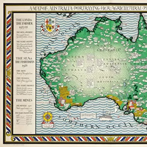
Photographic Print : Map of Australia showing the New Southern Settlement


![]()
Photo Prints from Mary Evans Picture Library
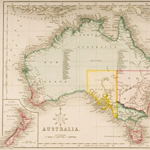
Map of Australia showing the New Southern Settlement
Map of Australia showing the New Southern Settlement - The Mirror Vol. XXX October 1837
Mary Evans Picture Library makes available wonderful images created for people to enjoy over the centuries
Media ID 19885996
© Mary Evans Picture Library
10"x10" Photo Print
Bring a piece of historical Australiana into your home with our exquisite Media Storehouse Photographic Prints. This captivating image, "Map of Australia showing the New Southern Settlement," hails from The Mirror Vol. XXX, October 1837, and is now available as a rights-managed print from Mary Evans Prints Online. This intricately detailed map showcases the expanding Australian colonies in the mid-19th century, offering a fascinating glimpse into the country's history. Each print is meticulously reproduced with the utmost care, ensuring vibrant colors and sharp details that will impress any viewer. Elevate your decor and transport yourself back in time with this unique and captivating addition to your collection.
Photo prints are produced on Kodak professional photo paper resulting in timeless and breath-taking prints which are also ideal for framing. The colors produced are rich and vivid, with accurate blacks and pristine whites, resulting in prints that are truly timeless and magnificent. Whether you're looking to display your prints in your home, office, or gallery, our range of photographic prints are sure to impress. Dimensions refers to the size of the paper in inches.
Our Photo Prints are in a large range of sizes and are printed on Archival Quality Paper for excellent colour reproduction and longevity. They are ideal for framing (our Framed Prints use these) at a reasonable cost. Alternatives include cheaper Poster Prints and higher quality Fine Art Paper, the choice of which is largely dependant on your budget.
Estimated Product Size is 25.4cm x 25.4cm (10" x 10")
These are individually made so all sizes are approximate
Artwork printed orientated as per the preview above, with landscape (horizontal) or portrait (vertical) orientation to match the source image.
FEATURES IN THESE COLLECTIONS
> Maps and Charts
> Related Images
> Oceania
> Australia
> Related Images
EDITORS COMMENTS
This intriguing map, titled "Australia," published in The Mirror Vol. XXX, October 1837, presents a visionary proposal for a new southern settlement in Australia. Unlike other maps of the time, which primarily focused on the known European colonies, this map extends southward, suggesting a bold expansion of the British presence in the region. The New Southern Settlement, marked by the cluster of dots and the inscription "New Southern Settlement," is situated near the southern tip of the continent, in an area that was largely unexplored and unknown to Europeans at the time. The map's creator, likely an enthusiastic advocate for colonization, envisioned this settlement as a potential solution to overpopulation in Europe and a means to expand the British Empire. The map also features other points of interest, including the known European colonies of New South Wales, Van Diemen's Land (Tasmania), and Swan River (Perth), as well as the various exploratory expeditions that had been undertaken in the region. The map's detailed topography, accurate coastlines, and clear labeling make it a valuable historical document, shedding light on the exploratory spirit and colonial ambitions of the early 19th century. This map offers a fascinating glimpse into the past, revealing the dreams and aspirations of those who sought to expand their territories and influence, as well as the limitations of knowledge and exploration during this era. It serves as a reminder of the rich history of Australia and the role that maps have played in shaping our understanding of the world.
MADE IN THE USA
Safe Shipping with 30 Day Money Back Guarantee
FREE PERSONALISATION*
We are proud to offer a range of customisation features including Personalised Captions, Color Filters and Picture Zoom Tools
SECURE PAYMENTS
We happily accept a wide range of payment options so you can pay for the things you need in the way that is most convenient for you
* Options may vary by product and licensing agreement. Zoomed Pictures can be adjusted in the Cart.