Photographic Print > Africa > Egypt > Maps
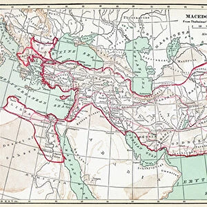
Photographic Print : Map of the Empire of King Alexander the Great


![]()
Photo Prints from Mary Evans Picture Library
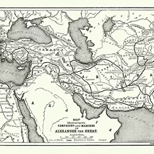
Map of the Empire of King Alexander the Great
Map of the Empire of King Alexander the Great (Alexander III of Macedon 356323 BC), from Greece in the west to India in the east. Date: 1807
Mary Evans Picture Library makes available wonderful images created for people to enjoy over the centuries
Media ID 11575333
© Mary Evans / Grenville Collins Postcard Collection
1807 Alexander Arabia Caspian Chart Conquered Hellenic League Libya Macedon Macedonia Maps Mediterranean Persia Persian Pharaoh Scythia Shahanshah Silk Territories Territory Aral Basileus
10"x8" Photo Print
Discover the rich history of ancient Macedonia with our stunning selection of Media Storehouse Photographic Prints featuring the "Map of the Empire of King Alexander the Great" by Rights Managed from Mary Evans Prints Online. This intricately detailed map, created in 1807, showcases the vast expanse of Alexander III of Macedon's empire, stretching from Greece in the west to India in the east. Bring history to life in your home or office with this beautiful and educational print, perfect for history enthusiasts, educators, or anyone interested in the ancient world. Order yours today and transport yourself back in time.
Photo prints are produced on Kodak professional photo paper resulting in timeless and breath-taking prints which are also ideal for framing. The colors produced are rich and vivid, with accurate blacks and pristine whites, resulting in prints that are truly timeless and magnificent. Whether you're looking to display your prints in your home, office, or gallery, our range of photographic prints are sure to impress. Dimensions refers to the size of the paper in inches.
Our Photo Prints are in a large range of sizes and are printed on Archival Quality Paper for excellent colour reproduction and longevity. They are ideal for framing (our Framed Prints use these) at a reasonable cost. Alternatives include cheaper Poster Prints and higher quality Fine Art Paper, the choice of which is largely dependant on your budget.
Estimated Product Size is 25.4cm x 20.3cm (10" x 8")
These are individually made so all sizes are approximate
Artwork printed orientated as per the preview above, with landscape (horizontal) or portrait (vertical) orientation to match the source image.
FEATURES IN THESE COLLECTIONS
> Africa
> Egypt
> Related Images
> Africa
> Libya
> Related Images
> Asia
> India
> Related Images
> Asia
> Related Images
> Europe
> Greece
> Related Images
> Popular Themes
> Maps and Charts
EDITORS COMMENTS
This stunning antique map print, created in the year 1807, depicts the vast territories of the Empire of King Alexander the Great, also known as Alexander III of Macedon (356-323 BC). The map extends from Greece in the west to India in the east, showcasing the vast expanse of land that was once ruled by this legendary conqueror. Alexander's empire included the Middle East, Persia, and parts of Central Asia, stretching from the Caspian Sea in the north to the Arabian Gulf in the south. The map accurately illustrates the territories he conquered, including Egypt, Phrygia, Syria, Babylon, and the Indus Valley. The map also highlights key geographical features such as the Black Sea, Mediterranean Sea, Aral Sea, and the mighty River Nile. The territories of Scythia, Arabia, and the Persian Gulf are also clearly marked. Alexander the Great is depicted as the 'Basileus' or 'King' of Macedonia and 'Hegemon' of the Hellenic League. He is also referred to as the 'Lord of Asia' and 'Shahanshah' of Persia, reflecting his dual role as the ruler of the Greek world and the Persian Empire. This map is a testament to the historical significance of Alexander the Great and the vast territory he conquered during his reign. It is an essential resource for scholars, historians, and anyone interested in ancient history, particularly the history of the Middle East and Asia. The map is intricately detailed, with a clear and easy-to-read key, making it an excellent addition to any collection of historical maps or a research library. The map's antique charm and historical accuracy make it a fascinating and educational piece to display in any home or office.
MADE IN THE USA
Safe Shipping with 30 Day Money Back Guarantee
FREE PERSONALISATION*
We are proud to offer a range of customisation features including Personalised Captions, Color Filters and Picture Zoom Tools
SECURE PAYMENTS
We happily accept a wide range of payment options so you can pay for the things you need in the way that is most convenient for you
* Options may vary by product and licensing agreement. Zoomed Pictures can be adjusted in the Cart.