Photographic Print > Europe > Iceland > Maps
Photographic Print : Map / Europe / Iceland 18C


![]()
Photo Prints from Mary Evans Picture Library
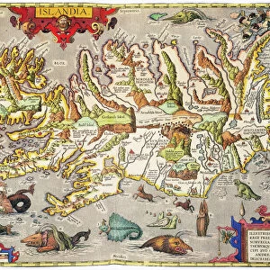
Map / Europe / Iceland 18C
Date: early 18th century
Mary Evans Picture Library makes available wonderful images created for people to enjoy over the centuries
Media ID 571502
© Mary Evans Picture Library 2015 - https://copyrighthub.org/s0/hub1/creation/maryevans/MaryEvansPictureID/10003760
10"x8" Photo Print
Introducing the stunning "Map / Europe / Iceland 18C" print from Mary Evans Picture Library, now available through Media Storehouse's extensive range of Photographic Prints. This captivating early 18th century map of Iceland offers a unique glimpse into Europe's historical geography. The intricate details and vibrant colors bring the island's terrain and topography to life, making this a must-have addition to any home or office decor. With its rich historical significance, the "Map / Europe / Iceland 18C" print is not just a beautiful piece of art, but also a window into the past. Order yours today from Media Storehouse and let history come alive in your space.
Photo prints are produced on Kodak professional photo paper resulting in timeless and breath-taking prints which are also ideal for framing. The colors produced are rich and vivid, with accurate blacks and pristine whites, resulting in prints that are truly timeless and magnificent. Whether you're looking to display your prints in your home, office, or gallery, our range of photographic prints are sure to impress. Dimensions refers to the size of the paper in inches.
Our Photo Prints are in a large range of sizes and are printed on Archival Quality Paper for excellent colour reproduction and longevity. They are ideal for framing (our Framed Prints use these) at a reasonable cost. Alternatives include cheaper Poster Prints and higher quality Fine Art Paper, the choice of which is largely dependant on your budget.
Estimated Image Size (if not cropped) is 25.4cm x 18.5cm (10" x 7.3")
Estimated Product Size is 25.4cm x 20.3cm (10" x 8")
These are individually made so all sizes are approximate
Artwork printed orientated as per the preview above, with landscape (horizontal) orientation to match the source image.
FEATURES IN THESE COLLECTIONS
> Europe
> Iceland
> Related Images
> Europe
> Related Images
> Maps and Charts
> Early Maps
> Maps and Charts
> Related Images
EDITORS COMMENTS
This print of a historical map of Europe, specifically focusing on Iceland in the early 18th century, offers a fascinating glimpse into the past. The intricate details and delicate craftsmanship of this map showcase the cartographer's skill and dedication to accurately representing the geography of this region during that time period.
As we study this map, we are transported back to a time when exploration and discovery were at the forefront of society. The names of towns, rivers, and mountains are carefully labeled, providing valuable insight into how people navigated and understood their world centuries ago.
Iceland, with its rugged terrain and unique cultural heritage, is prominently featured on this map, reminding us of its importance in European history. From Reykjavik to Akureyri, each place is meticulously depicted with precision and care.
This print from Mary Evans Picture Library serves as a reminder of the rich history that has shaped our world today. It invites us to explore the past through cartography and appreciate the artistry involved in creating such detailed maps. Whether you are a history buff or simply intrigued by old-world charm, this map is sure to captivate your imagination and inspire further exploration into Europe's fascinating past.
MADE IN THE USA
Safe Shipping with 30 Day Money Back Guarantee
FREE PERSONALISATION*
We are proud to offer a range of customisation features including Personalised Captions, Color Filters and Picture Zoom Tools
SECURE PAYMENTS
We happily accept a wide range of payment options so you can pay for the things you need in the way that is most convenient for you
* Options may vary by product and licensing agreement. Zoomed Pictures can be adjusted in the Cart.