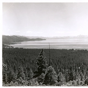
Photographic Print > North America > United States of America > Lakes > Lake Tahoe
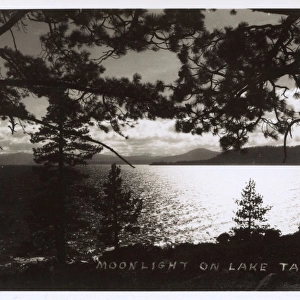
Photographic Print : Map of the Lake Tahoe area, Nevada and California, USA


![]()
Photo Prints from Mary Evans Picture Library
Map of the Lake Tahoe area, Nevada and California, USA
Map of the Lake Tahoe area, Nevada and California, USA, showing the highway system. Date: 1922
Mary Evans Picture Library makes available wonderful images created for people to enjoy over the centuries
Media ID 14262245
© Mary Evans / Pharcide
California Highway Highways Maps Nevada Roads Tahoe 1922
11"x8.5" Photo Print
Discover the historic charm of Lake Tahoe with our exquisite Map of the Lake Tahoe area print from Media Storehouse. Dated back to 1922, this vintage map, sourced from Mary Evans Prints Online, showcases the Lake Tahoe region in Nevada and California with intricate detail. Highlighting the highway system, this rights managed print is perfect for history enthusiasts, travelers, or those who appreciate the beauty of vintage cartography. Bring a piece of the past into your home or office and add a unique touch to your decor.
Photo prints are produced on Kodak professional photo paper resulting in timeless and breath-taking prints which are also ideal for framing. The colors produced are rich and vivid, with accurate blacks and pristine whites, resulting in prints that are truly timeless and magnificent. Whether you're looking to display your prints in your home, office, or gallery, our range of photographic prints are sure to impress. Dimensions refers to the size of the paper in inches.
Our Photo Prints are in a large range of sizes and are printed on Archival Quality Paper for excellent colour reproduction and longevity. They are ideal for framing (our Framed Prints use these) at a reasonable cost. Alternatives include cheaper Poster Prints and higher quality Fine Art Paper, the choice of which is largely dependant on your budget.
Estimated Image Size (if not cropped) is 27.9cm x 18cm (11" x 7.1")
Estimated Product Size is 27.9cm x 21.6cm (11" x 8.5")
These are individually made so all sizes are approximate
Artwork printed orientated as per the preview above, with landscape (horizontal) orientation to match the source image.
FEATURES IN THESE COLLECTIONS
> Animals
> Mammals
> Cricetidae
> California Mouse
> Animals
> Mammals
> Muridae
> Water Mouse
> Animals
> Mammals
> Muridae
> Western Mouse
> Maps and Charts
> Related Images
> North America
> United States of America
> California
> Related Images
> North America
> United States of America
> Lakes
> Lake Tahoe
> North America
> United States of America
> Lakes
> Related Images
> North America
> United States of America
> Maps
> North America
> United States of America
> Nevada
> Related Images
EDITORS COMMENTS
1. Title: "A Journey Through Time: Navigating the Highways of Lake Tahoe, Nevada and California, 1922" This vintage map print, hailing from the year 1922, offers a captivating glimpse into the transportation landscape of Lake Tahoe, situated in the western United States, encompassing parts of Nevada and California. The map meticulously depicts the intricate network of roads and highways that crisscrossed the region during the Roaring Twenties, a time of significant growth and development in the American West. The Lake Tahoe area, a popular tourist destination even in the 1920s, is showcased in all its splendor. The crystal-clear waters of the lake, nestled amidst the majestic Sierra Nevada Mountains, are highlighted, as are the surrounding forests and picturesque towns. The map not only serves as a visual representation of the region's geography but also offers a window into the past, providing insight into the transportation infrastructure that connected communities and facilitated travel during this era. The intricate details on the map reveal the various roads and highways that snaked through the rugged terrain, connecting the towns and cities of Nevada and California. The primary focus is on U.S. Routes 50 and 40, which served as the main arteries for travel between the East and West Coasts during the 1920s. Other notable roads, such as State Routes 28 and 29, are also depicted, providing a comprehensive view of the region's transportation network. This map print is an essential addition to any collection focusing on American history, transportation, or the western United States. It offers a unique perspective on the past and serves as a reminder of the significant role that roads and highways played in shaping the way we travel and explore our world.
MADE IN THE USA
Safe Shipping with 30 Day Money Back Guarantee
FREE PERSONALISATION*
We are proud to offer a range of customisation features including Personalised Captions, Color Filters and Picture Zoom Tools
SECURE PAYMENTS
We happily accept a wide range of payment options so you can pay for the things you need in the way that is most convenient for you
* Options may vary by product and licensing agreement. Zoomed Pictures can be adjusted in the Cart.