Photographic Print > Europe > Spain > Related Images
Photographic Print : Map of Saint Petersburg (1834). Original drawing
. Original drawing")

![]()
Photo Prints from Mary Evans Picture Library
Map of Saint Petersburg (1834). Original drawing
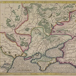
" Map of Saint Petersburg (1834). Original drawing by W.B. Clarke and engraving by B. Davies, originally published under supervision of the Society for the Diffusion of Useful Knowledge. From the work " De comparative urban design", by Melville C. Branch (New York, 1978). Engraving. SPAIN. Barcelona. Biblioteca de Catalunya (National Library of Catalonia)."
Mary Evans Picture Library makes available wonderful images created for people to enjoy over the centuries
Media ID 8279221
© Mary Evans Picture Library 2015 - https://copyrighthub.org/s0/hub1/creation/maryevans/MaryEvansPictureID/10684016
Clarke Comparative Davies Diffusion Knowledge Melville Originally Petersburg Supervision
10"x8" Photo Print
Discover the rich history of Saint Petersburg with our exquisite photographic print from Media Storehouse. This captivating image showcases an original drawing of the map of Saint Petersburg, dating back to 1834. Meticulously sourced from Mary Evans Prints Online, this map was created by W.B. Clarke and intricately engraved by B. Davies under the supervision of the Society for the Diffusion of Useful Knowledge. Each detail, from the winding canals to the grand architecture, is beautifully rendered, making this print an essential addition to your home or office decor. Transport yourself back in time and add a touch of historical charm to your space with this stunning, high-quality photographic print.
Photo prints are produced on Kodak professional photo paper resulting in timeless and breath-taking prints which are also ideal for framing. The colors produced are rich and vivid, with accurate blacks and pristine whites, resulting in prints that are truly timeless and magnificent. Whether you're looking to display your prints in your home, office, or gallery, our range of photographic prints are sure to impress. Dimensions refers to the size of the paper in inches.
Our Photo Prints are in a large range of sizes and are printed on Archival Quality Paper for excellent colour reproduction and longevity. They are ideal for framing (our Framed Prints use these) at a reasonable cost. Alternatives include cheaper Poster Prints and higher quality Fine Art Paper, the choice of which is largely dependant on your budget.
Estimated Product Size is 25.4cm x 20.3cm (10" x 8")
These are individually made so all sizes are approximate
Artwork printed orientated as per the preview above, with landscape (horizontal) orientation to match the source image.
FEATURES IN THESE COLLECTIONS
> Europe
> Spain
> Related Images
> North America
> United States of America
> New York
> Related Images
EDITORS COMMENTS
This print showcases an original drawing of a map of Saint Petersburg, Russia, created by W.B. Clarke in 1834. The map was later engraved by B. Davies under the supervision of the Society for the Diffusion of Useful Knowledge. The map is a significant historical artifact, offering a glimpse into the urban design and layout of Saint Petersburg during the early 19th century. The Society for the Diffusion of Useful Knowledge was an influential British organization dedicated to the dissemination of knowledge and education. Their publication of this map reflects their commitment to making accurate and detailed information accessible to the public. The map's intricate details and precise labeling demonstrate the meticulous efforts of both Clarke and Davies in creating an accurate representation of the city. The map's title, "Map of Saint Petersburg," is written in elegant script at the top, with the date "1834" and the names of the creators, "W.B. Clarke, Drawng [sic]" and "B. Davies, Engraving," appearing below. The map itself is surrounded by an ornate border, filled with intricate designs and decorative elements. This map is a valuable resource for urban historians, geographers, and anyone interested in the history of Saint Petersburg. It offers a unique perspective into the city's layout and design during a pivotal period in its history. Today, this original drawing and engraving is housed in the Biblioteca de Catalunya (National Library of Catalonia) in Barcelona, Spain, where it continues to be studied and appreciated by scholars and enthusiasts alike.
MADE IN THE USA
Safe Shipping with 30 Day Money Back Guarantee
FREE PERSONALISATION*
We are proud to offer a range of customisation features including Personalised Captions, Color Filters and Picture Zoom Tools
SECURE PAYMENTS
We happily accept a wide range of payment options so you can pay for the things you need in the way that is most convenient for you
* Options may vary by product and licensing agreement. Zoomed Pictures can be adjusted in the Cart.