Photographic Print > Europe > Italy > Sicily > Palermo
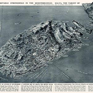
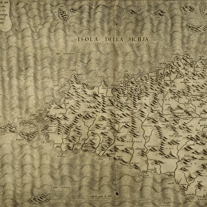
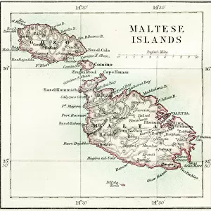
Photographic Print : Map of Sicily by G. H. Davis


![]()
Photo Prints from Mary Evans Picture Library
Map of Sicily by G. H. Davis
A contour map of Sicily, giving the shortest air distances from Cape Bon and Malta. At this stage in the Second World War it was a British front-line objective in Axis eyes, a target of major air attacks on Palermo and other strategic points, and the stepping stone to Italy. Date: 1943
Mary Evans Picture Library makes available wonderful images created for people to enjoy over the centuries
Media ID 14133379
© Illustrated London News Ltd/Mary Evans
1943 Allied Allies Attack Attacks Axis Cape Contour Davis Distance Distances Focal Focus Ionian Major Malta Maps Mediterranean Palermo Points Sicilian Sicily Stepping Strategic Target Tyrrhenian Objective
10"x8" Photo Print
Discover the historical depth of Sicily with our exquisite Media Storehouse Photographic Print of the "Map of Sicily by G. H. Davis." This rights-managed print, sourced from Mary Evans Prints Online, transports you back in time with intricate contour details, highlighting the shortest air distances from Cape Bon and Malta during the Second World War. A fascinating addition to your home or office decor, this map holds significant historical value, showcasing Sicily as a British front-line objective in Axis eyes. Bring a piece of history into your space with our high-quality photographic prints.
Photo prints are produced on Kodak professional photo paper resulting in timeless and breath-taking prints which are also ideal for framing. The colors produced are rich and vivid, with accurate blacks and pristine whites, resulting in prints that are truly timeless and magnificent. Whether you're looking to display your prints in your home, office, or gallery, our range of photographic prints are sure to impress. Dimensions refers to the size of the paper in inches.
Our Photo Prints are in a large range of sizes and are printed on Archival Quality Paper for excellent colour reproduction and longevity. They are ideal for framing (our Framed Prints use these) at a reasonable cost. Alternatives include cheaper Poster Prints and higher quality Fine Art Paper, the choice of which is largely dependant on your budget.
Estimated Image Size (if not cropped) is 17.9cm x 25.4cm (7" x 10")
Estimated Product Size is 20.3cm x 25.4cm (8" x 10")
These are individually made so all sizes are approximate
Artwork printed orientated as per the preview above, with portrait (vertical) orientation to match the source image.
FEATURES IN THESE COLLECTIONS
> Europe
> France
> Canton
> Allier
> Europe
> Italy
> Related Images
> Europe
> Italy
> Sicily
> Palermo
> Europe
> Italy
> Sicily
> Related Images
> Europe
> Malta
> Related Images
EDITORS COMMENTS
This contour map of Sicily, created by renowned cartographer G.H. Davis in 1943, offers a unique glimpse into the strategic importance of the island during the Second World War. At this pivotal moment in history, Sicily served as a British front-line objective in Axis eyes, a target of major air attacks on Palermo and other strategic points, and the stepping stone to Italy. The map, titled "Map of Sicily: Showing the Shortest Air Distances from Cape Bon and Malta," highlights the island's location in the Mediterranean Sea, bordered by the Ionian and Tyrrhenian Seas. The contour lines provide a detailed representation of the island's topography, while the inclusion of air distances from Cape Bon and Malta underscores Sicily's significance as a key military and logistical hub. During the war, Sicily was a focal point of Allied and Axis attention. The island's capture by the Allies in July 1943 marked a turning point in the war, as it provided a base for further operations in Italy and the Mediterranean. The map reflects the intense focus on Sicily as a military objective, with the major air attacks on Palermo and other strategic points evident in the damage and destruction depicted on the map. This historical map provides a fascinating window into the wartime history of Sicily and the Mediterranean region, offering insights into the strategic considerations and military operations that shaped the course of the Second World War in Europe.
MADE IN THE USA
Safe Shipping with 30 Day Money Back Guarantee
FREE PERSONALISATION*
We are proud to offer a range of customisation features including Personalised Captions, Color Filters and Picture Zoom Tools
SECURE PAYMENTS
We happily accept a wide range of payment options so you can pay for the things you need in the way that is most convenient for you
* Options may vary by product and licensing agreement. Zoomed Pictures can be adjusted in the Cart.