Photographic Print > Animals > Mammals > Muridae > Fortior
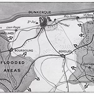
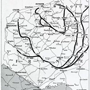
Photographic Print : Map of France and Belgium, evacuation from Dunkirk, WW2


![]()
Photo Prints from Mary Evans Picture Library
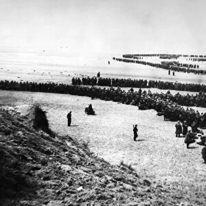
Map of France and Belgium, evacuation from Dunkirk, WW2
Map of the northern French and Belgian coast, showing the evacuation from Dunkirk and other points, and the evacuation triangle through which the Allied army retreated, and the area of the rearguard fight. Date: 1940
Mary Evans Picture Library makes available wonderful images created for people to enjoy over the centuries
Media ID 23275250
© Illustrated London News Ltd/Mary Evans
Bergues Dunkirk Evacuated Evacuation Expeditionary Maps Nov19 Poperinghe Rescue Rescued Return Saved
10"x8" Photo Print
Step back in time with our captivating selection from the Media Storehouse range of Photographic Prints. This evocative image, "Map of France and Belgium, evacuation from Dunkirk, WW2," transports you to the historical heart of the Second World War. The meticulously detailed map displays the northern French and Belgian coastline, marking the strategic evacuation points from Dunkirk and other key areas. Witness the Allied army's harrowing retreat through the evacuation triangle, as history unfolds before your eyes. A perfect addition to any history lover's collection, this print is available through our Rights Managed partnership with Mary Evans Prints Online.
Photo prints are produced on Kodak professional photo paper resulting in timeless and breath-taking prints which are also ideal for framing. The colors produced are rich and vivid, with accurate blacks and pristine whites, resulting in prints that are truly timeless and magnificent. Whether you're looking to display your prints in your home, office, or gallery, our range of photographic prints are sure to impress. Dimensions refers to the size of the paper in inches.
Our Photo Prints are in a large range of sizes and are printed on Archival Quality Paper for excellent colour reproduction and longevity. They are ideal for framing (our Framed Prints use these) at a reasonable cost. Alternatives include cheaper Poster Prints and higher quality Fine Art Paper, the choice of which is largely dependant on your budget.
Estimated Product Size is 25.4cm x 20.3cm (10" x 8")
These are individually made so all sizes are approximate
Artwork printed orientated as per the preview above, with landscape (horizontal) orientation to match the source image.
FEATURES IN THESE COLLECTIONS
> Mary Evans Prints Online
> New Images August 2021
> Animals
> Mammals
> Muridae
> Fortior
> Europe
> Belgium
> Related Images
> Historic
> World War I and II
> World War II
> Maps and Charts
> Related Images
EDITORS COMMENTS
This evocative map print depicts the northern French and Belgian coast during the momentous evacuation from Dunkirk in 1940, a pivotal event in World War II. The map, dated November 19, 1940, highlights the strategic locations of the evacuation from Dunkirk and other points along the coast, as well as the evacuation triangle through which the Allied army retreated. The area of the rearguard fight is also marked, emphasizing the intense and desperate nature of the battle. The evacuation of Allied troops from Dunkirk, which took place between May 26 and June 4, 1940, was a remarkable feat of military logistics. Over the course of nine days, more than 338,000 soldiers were rescued from the beaches of Dunkirk and the surrounding area, thanks to a fleet of over 800 boats, both civilian and military. The evacuation was a crucial turning point in the war, as it prevented the complete destruction of the British Expeditionary Force (BEF) and allowed the Allies to regroup and prepare for future battles. The map also indicates the locations of key towns and cities along the coast, including Bergues and Poperinghe in Belgium. These towns played an important role in the evacuation, serving as staging areas for the troops and providing vital supplies and resources to the evacuating forces. The map serves as a poignant reminder of the bravery and resilience of the soldiers involved in the evacuation, as well as the critical role played by the civilian population in supporting the war effort. This map print offers a unique and insightful perspective on the events of the Dunkirk evacuation, making it an essential addition to any collection of World War II history or military memorabilia.
MADE IN THE USA
Safe Shipping with 30 Day Money Back Guarantee
FREE PERSONALISATION*
We are proud to offer a range of customisation features including Personalised Captions, Color Filters and Picture Zoom Tools
SECURE PAYMENTS
We happily accept a wide range of payment options so you can pay for the things you need in the way that is most convenient for you
* Options may vary by product and licensing agreement. Zoomed Pictures can be adjusted in the Cart.