Photographic Print > Europe > Germany > Maps
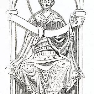
Photographic Print : GROWTH OF PRUSSIA / MAP

![]()
Photo Prints from Mary Evans Picture Library
GROWTH OF PRUSSIA / MAP
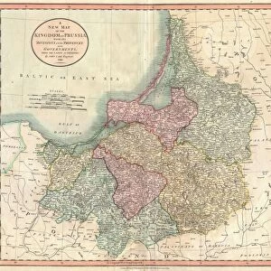
The growth of Prussia between 1815 and 1866 Date: 1866
Mary Evans Picture Library makes available wonderful images created for people to enjoy over the centuries
Media ID 20148935
© Bubblepunk
12"x8" Photo Print
Experience history come to life with our exquisite selection of Media Storehouse Photographic Prints. This captivating piece, "GROWTH OF PRUSSIA / MAP" from Mary Evans Prints Online, showcases the expansion of Prussia between 1815 and 1866. Each print is meticulously crafted to bring out the intricate details of the map, transporting you back in time. Ideal for history enthusiasts, educators, or those seeking unique decor for their space, these high-quality prints make for a striking addition to any room. Relive the past, one print at a time.
Photo prints are produced on Kodak professional photo paper resulting in timeless and breath-taking prints which are also ideal for framing. The colors produced are rich and vivid, with accurate blacks and pristine whites, resulting in prints that are truly timeless and magnificent. Whether you're looking to display your prints in your home, office, or gallery, our range of photographic prints are sure to impress. Dimensions refers to the size of the paper in inches.
Our Photo Prints are in a large range of sizes and are printed on Archival Quality Paper for excellent colour reproduction and longevity. They are ideal for framing (our Framed Prints use these) at a reasonable cost. Alternatives include cheaper Poster Prints and higher quality Fine Art Paper, the choice of which is largely dependant on your budget.
Estimated Image Size (if not cropped) is 18.7cm x 30.4cm (7.4" x 12")
Estimated Product Size is 20.3cm x 30.5cm (8" x 12")
These are individually made so all sizes are approximate
Artwork printed orientated as per the preview above, with portrait (vertical) orientation to match the source image.
FEATURES IN THESE COLLECTIONS
> Mary Evans Prints Online
> New Images July 2020
> Europe
> Germany
> Related Images
> Maps and Charts
> Related Images
EDITORS COMMENTS
This map print from 1866, titled "The Growth of Prussia between 1815 and 1866," offers a compelling visual representation of the significant territorial expansion of the Prussian state during this period. Prussia, a prominent German state located in Central Europe, underwent a remarkable transformation from a modest entity in the aftermath of the Napoleonic Wars in 1815 to a powerful and influential European power by the mid-19th century. The map illustrates the series of key events that contributed to Prussia's growth, starting with the Congress of Vienna in 1815, which reorganized Europe after the Napoleonic Wars. Prussia emerged from these negotiations with several new territories, including parts of western Poland and the Rhineland. The map then charts Prussia's involvement in various conflicts, including the Schleswig-Holstein War in 1848 and the Seven Weeks' War against Austria in 1866. These victories resulted in the annexation of significant territories, such as Schleswig-Holstein, Hanover, Hesse-Cassel, and Nassau. By the time this map was produced in 1866, Prussia had become a major European power, with its territories stretching from the North Sea to the Alps. The map serves as a testament to Prussia's military prowess and diplomatic skill during this era. It also highlights the complex political landscape of Europe during the 19th century, with its shifting borders and alliances. The intricate details on this map, including the use of various shades and hues to represent different territories, make for an engaging visual experience. The map's historical significance and aesthetic appeal make it an essential addition to any collection focused on European history, cartography, or geography.
MADE IN THE USA
Safe Shipping with 30 Day Money Back Guarantee
FREE PERSONALISATION*
We are proud to offer a range of customisation features including Personalised Captions, Color Filters and Picture Zoom Tools
SECURE PAYMENTS
We happily accept a wide range of payment options so you can pay for the things you need in the way that is most convenient for you
* Options may vary by product and licensing agreement. Zoomed Pictures can be adjusted in the Cart.