Photographic Print > Historic > Ancient civilizations > Aztec Empire > Mesoamerica
Photographic Print : Map of the territory of New Spain


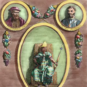
![]()
Photo Prints from Mary Evans Picture Library
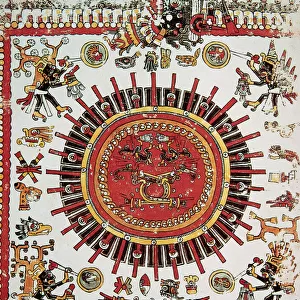
Map of the territory of New Spain
Map of the territory of New Spain. Historia de la Conquista de Mexico, poblacion, y progresos de la America septentrional, conocida por el nombre de Nueva Espana (History of the Conquest of Mexico, population, and progress of northern America, known by the name of New Spain). Written by Antonio de Solis y Rivadeneryra (1610-1686), Chronicler of the Indies. Volume I. Edition published in Barcelona and divided into two volumes, 1771. King's printer: Thomas Piferrer. Historical Military Library of Barcelona. Catalonia, Spain
Mary Evans Picture Library makes available wonderful images created for people to enjoy over the centuries
Media ID 32271052
© Thaliastock / Mary Evans
1771 Antonio Aztec Aztecs Cancer Cartography Conquest Continent Cortes Geography Gulf Hernan Indies Mapping Mesoamerica Mexican Mexico Pacific Rivadeneyra Solis Tropic Viceroyalty
10"x8" Photo Print
Discover the rich history of New Spain with our stunning Prisma Archivo Fotografico photographic print from Mary Evans Prints Online. This captivating image, titled "Map of the territory of New Spain" from the publication "History of the Conquest of Mexico, poblacion, y progresos de la America septentrional, conocida por el nombre de Nueva Espana," transports you back in time to the era of exploration and colonization. This intricately detailed map showcases the vast territories of New Spain, offering a unique perspective into the geography and political landscape of the time. Bring history to life in your home or office with this beautiful and informative piece of art.
Photo prints are produced on Kodak professional photo paper resulting in timeless and breath-taking prints which are also ideal for framing. The colors produced are rich and vivid, with accurate blacks and pristine whites, resulting in prints that are truly timeless and magnificent. Whether you're looking to display your prints in your home, office, or gallery, our range of photographic prints are sure to impress. Dimensions refers to the size of the paper in inches.
Our Photo Prints are in a large range of sizes and are printed on Archival Quality Paper for excellent colour reproduction and longevity. They are ideal for framing (our Framed Prints use these) at a reasonable cost. Alternatives include cheaper Poster Prints and higher quality Fine Art Paper, the choice of which is largely dependant on your budget.
Estimated Product Size is 20.3cm x 25.4cm (8" x 10")
These are individually made so all sizes are approximate
Artwork printed orientated as per the preview above, with landscape (horizontal) or portrait (vertical) orientation to match the source image.
FEATURES IN THESE COLLECTIONS
> Mary Evans Prints Online
> New Images July 2023
> Arts
> Artists
> N
> Thomas North
> Arts
> Artists
> O
> Oceanic Oceanic
> Europe
> Spain
> Related Images
> Historic
> Ancient civilizations
> Aztec Empire
> Mesoamerica
> Historic
> Ancient civilizations
> Aztec Empire
EDITORS COMMENTS
This stunning print captures a piece of history with the Map of the territory of New Spain from Antonio de Solis y Rivadeneryra's "Historia de la Conquista de Mexico." Published in Barcelona in 1771, this map provides a detailed look at the conquest and progress of northern America, known as New Spain.
The intricate details on this map showcase the vast territories controlled by the Spanish Empire during the 16th and 17th centuries. From Mesoamerica to the Aztec civilization, this map highlights key regions and landmarks that played a crucial role in shaping modern-day Mexico.
As you study this map, you can't help but marvel at the cartographic skills used to accurately depict geographical features such as rivers, mountains, and coastlines. The strategic placement of cities and settlements gives insight into how colonization efforts were carried out during this era.
With its depiction of the Pacific Ocean, Gulf of Mexico, and Tropic of Cancer, this map serves as a valuable historical artifact that sheds light on Spain's influence in North America. It is a testament to the legacy left behind by explorers like Hernan Cortes and chroniclers like Antonio de Solis y Rivadeneryra.
Overall, this print is not just a visual representation but also a gateway to understanding the complex history of New Spain and its impact on American continent.
MADE IN THE USA
Safe Shipping with 30 Day Money Back Guarantee
FREE PERSONALISATION*
We are proud to offer a range of customisation features including Personalised Captions, Color Filters and Picture Zoom Tools
SECURE PAYMENTS
We happily accept a wide range of payment options so you can pay for the things you need in the way that is most convenient for you
* Options may vary by product and licensing agreement. Zoomed Pictures can be adjusted in the Cart.