Photographic Print > Europe > Russia > Maps
Photographic Print : Daily Mail War Map, WW1


Photo Prints from Mary Evans Picture Library
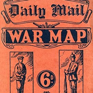
Daily Mail War Map, WW1
A fold out war map issued by the Daily Mail in the early weeks of the First World War. The map offers statistics regarding the manpower strength of each of the warring nations, as well as the number of battleships and food stores each had. While the Triple Entente of Britain, France and Russia could boast 9, 380, 000 men (of which Britain comprised just 380, 000), the Triple Alliance numbered 9, 500, 000. The map was intended to be marked with Philips flag pins in ten different colours so that civilians could chart the progress of the campaign. Date: 1914
Mary Evans Picture Library makes available wonderful images created for people to enjoy over the centuries
Media ID 14185852
© Mary Evans Picture Library
Battleships Borders Conflict Countries Daily Entente Fold Mail Manpower Maps Nations Outbreak Progress Statistics Strength Triple Warring
11"x8.5" Photo Print
Introducing the Media Storehouse range of Historical Photographic Prints, featuring the captivating "Daily Mail War Map, WW1" from Mary Evans Prints Online. This rare and intriguing print offers a glimpse into history with an authentic fold-out war map issued by the Daily Mail in the early weeks of the First World War. Delve into the statistics and data representing the manpower strength of each of the warring nations, providing a unique perspective on the global conflict. Add this historic piece to your collection and bring a piece of World War I history into your home or office.
Photo prints are produced on Kodak professional photo paper resulting in timeless and breath-taking prints which are also ideal for framing. The colors produced are rich and vivid, with accurate blacks and pristine whites, resulting in prints that are truly timeless and magnificent. Whether you're looking to display your prints in your home, office, or gallery, our range of photographic prints are sure to impress. Dimensions refers to the size of the paper in inches.
Our Photo Prints are in a large range of sizes and are printed on Archival Quality Paper for excellent colour reproduction and longevity. They are ideal for framing (our Framed Prints use these) at a reasonable cost. Alternatives include cheaper Poster Prints and higher quality Fine Art Paper, the choice of which is largely dependant on your budget.
Estimated Image Size (if not cropped) is 27.9cm x 19.3cm (11" x 7.6")
Estimated Product Size is 27.9cm x 21.6cm (11" x 8.5")
These are individually made so all sizes are approximate
Artwork printed orientated as per the preview above, with landscape (horizontal) orientation to match the source image.
FEATURES IN THESE COLLECTIONS
> Europe
> Related Images
> Europe
> Russia
> Related Images
> Historic
> World War I and II
> Civilians during the war
> Maps and Charts
> Early Maps
> Maps and Charts
> Popular Maps
> Maps and Charts
> Related Images
> Popular Themes
> Maps and Charts
EDITORS COMMENTS
This vintage print showcases the Daily Mail War Map of the First World War, published in the early days of the conflict in 1914. The intricately detailed map offers an insight into the military capabilities of the warring nations, with statistics on manpower strength and resources. The Triple Entente, comprised of Britain, France, and Russia, is depicted with a combined total of 9,380,000 men, with Britain contributing 380,000 of that number. In contrast, the Triple Alliance, consisting of Germany, Austria-Hungary, and Italy, boasts a formidable 9,500,000 men. The map was designed to be a personal tool for civilians, with the intention of marking it with Philips flag pins in ten different colors to track the progress of the campaign. This map serves as a poignant reminder of the vast scale and complexity of the European conflict that was to last for the next four years. As the world watched the borders of familiar countries shift and the devastating impact of war unfold, this map offered a visual representation of the statistics behind the headlines. This historical artifact not only offers a glimpse into the military strategies of the time but also serves as a testament to the power of information in shaping public perception during times of crisis.
MADE IN THE USA
Safe Shipping with 30 Day Money Back Guarantee
FREE PERSONALISATION*
We are proud to offer a range of customisation features including Personalised Captions, Color Filters and Picture Zoom Tools
SECURE PAYMENTS
We happily accept a wide range of payment options so you can pay for the things you need in the way that is most convenient for you
* Options may vary by product and licensing agreement. Zoomed Pictures can be adjusted in the Cart.