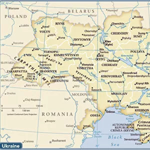
Photographic Print > Europe > Ukraine > Maps
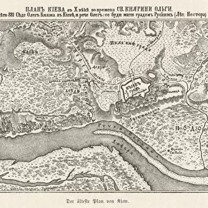
Photographic Print : Ukraine / Kiev / Old Map 881


![]()
Photo Prints from Mary Evans Picture Library
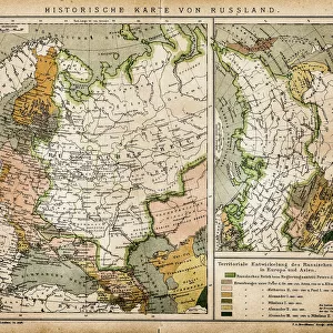
Ukraine / Kiev / Old Map 881
Kiev: the oldest known map
Mary Evans Picture Library makes available wonderful images created for people to enjoy over the centuries
Media ID 578712
© Mary Evans Picture Library 2015 - https://copyrighthub.org/s0/hub1/creation/maryevans/MaryEvansPictureID/10020398
11"x8.5" Photo Print
Introducing the captivating "Ukraine / Kiev / Old Map 881" print from Mary Evans Picture Library, exclusively available through Media Storehouse. This exquisite photograph offers a glimpse into the rich history of Kiev with an intriguing old map as its centerpiece. Dating back to an unknown era, this is believed to be the oldest known map of Kiev. Each print is meticulously crafted with high-quality materials to ensure a stunning and vivid representation of this historical treasure. Transport yourself back in time and adorn your walls with this unique and enchanting piece.
Photo prints are produced on Kodak professional photo paper resulting in timeless and breath-taking prints which are also ideal for framing. The colors produced are rich and vivid, with accurate blacks and pristine whites, resulting in prints that are truly timeless and magnificent. Whether you're looking to display your prints in your home, office, or gallery, our range of photographic prints are sure to impress. Dimensions refers to the size of the paper in inches.
Our Photo Prints are in a large range of sizes and are printed on Archival Quality Paper for excellent colour reproduction and longevity. They are ideal for framing (our Framed Prints use these) at a reasonable cost. Alternatives include cheaper Poster Prints and higher quality Fine Art Paper, the choice of which is largely dependant on your budget.
Estimated Image Size (if not cropped) is 27.9cm x 14.9cm (11" x 5.9")
Estimated Product Size is 27.9cm x 21.6cm (11" x 8.5")
These are individually made so all sizes are approximate
Artwork printed orientated as per the preview above, with landscape (horizontal) orientation to match the source image.
FEATURES IN THESE COLLECTIONS
> Europe
> Ukraine
> Related Images
> Maps and Charts
> Early Maps
> Maps and Charts
> Related Images
EDITORS COMMENTS
This stunning print captures a piece of history with "Ukraine / Kiev / Old Map 881" from Mary Evans Picture Library. The map, dating back to 881, is believed to be the oldest known map of Kiev, Ukraine. It offers a fascinating glimpse into the past, showcasing the intricate details and landmarks of this ancient city.
The historical significance of this map cannot be understated, as it provides valuable insights into the layout and development of Kiev over a thousand years ago. From its winding streets to its prominent buildings, every detail on this map tells a story of a bygone era.
As you gaze upon this remarkable piece of cartography, you can't help but feel transported back in time to when Kiev was just beginning to take shape. The craftsmanship and attention to detail that went into creating this map are truly awe-inspiring.
Whether you have a personal connection to Ukraine or simply appreciate history and old maps, "Ukraine / Kiev / Old Map 881" is sure to captivate your imagination. It serves as a reminder of how far we've come as a society while also honoring the rich heritage and culture of this beautiful country.
MADE IN THE USA
Safe Shipping with 30 Day Money Back Guarantee
FREE PERSONALISATION*
We are proud to offer a range of customisation features including Personalised Captions, Color Filters and Picture Zoom Tools
SECURE PAYMENTS
We happily accept a wide range of payment options so you can pay for the things you need in the way that is most convenient for you
* Options may vary by product and licensing agreement. Zoomed Pictures can be adjusted in the Cart.