Photographic Print > Asia > Vietnam > Maps
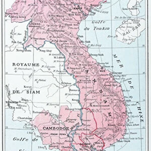
Photographic Print : Vietnam / Map C1930 French


![]()
Photo Prints from Mary Evans Picture Library
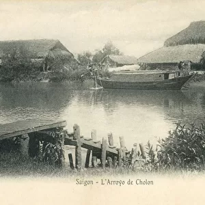
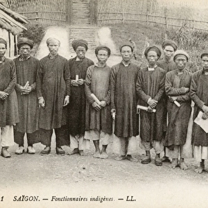
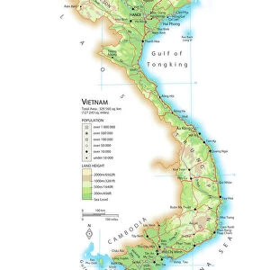
Vietnam / Map C1930 French
Card produced when La Cochinchine was a French colony
Mary Evans Picture Library makes available wonderful images created for people to enjoy over the centuries
Media ID 594891
© Mary Evans Picture Library 2015 - https://copyrighthub.org/s0/hub1/creation/maryevans/MaryEvansPictureID/10047568
11"x8.5" Photo Print
Discover the rich history of Vietnam with our exquisite photographic print from Mary Evans Picture Library. This captivating image, titled "Vietnam / Map C1930 French," offers a glimpse into the past when La Cochinchine was a French colony. The detailed map, beautifully rendered in black and white, invites you to explore the intricacies of Vietnam's geography during that era. Bring history into your home or office with this stunning, archival-quality print from Media Storehouse. Ideal for framing and a thoughtful gift for history enthusiasts or world travelers. Order yours today and let this piece serve as a conversation starter and a reminder of the fascinating stories that lie within the pages of history.
Photo prints are produced on Kodak professional photo paper resulting in timeless and breath-taking prints which are also ideal for framing. The colors produced are rich and vivid, with accurate blacks and pristine whites, resulting in prints that are truly timeless and magnificent. Whether you're looking to display your prints in your home, office, or gallery, our range of photographic prints are sure to impress. Dimensions refers to the size of the paper in inches.
Our Photo Prints are in a large range of sizes and are printed on Archival Quality Paper for excellent colour reproduction and longevity. They are ideal for framing (our Framed Prints use these) at a reasonable cost. Alternatives include cheaper Poster Prints and higher quality Fine Art Paper, the choice of which is largely dependant on your budget.
Estimated Image Size (if not cropped) is 27.9cm x 17.8cm (11" x 7")
Estimated Product Size is 27.9cm x 21.6cm (11" x 8.5")
These are individually made so all sizes are approximate
Artwork printed orientated as per the preview above, with landscape (horizontal) orientation to match the source image.
FEATURES IN THESE COLLECTIONS
> Asia
> Vietnam
> Related Images
> Maps and Charts
> Early Maps
> Maps and Charts
> Related Images
EDITORS COMMENTS
1. Title: "Vietnam Map - French Colony, Circa 1930" This historical map print, produced circa 1930, offers a glimpse into the geopolitical landscape of Vietnam during the French colonial era. The map, titled "Vietnam," was published when La Cochinchine, the southern region of present-day Vietnam, was under French rule. The map is an intriguing testament to the complex political divisions of the time. It meticulously delineates the various territories under French control, including Cochinchina, Annam, and Tonkin, as well as neighboring regions such as Cambodia and Laos. The map also highlights major cities, rivers, and geographical features, providing a detailed and accurate representation of the region's topography. The vibrant colors and clear cartography of the map make it an engaging visual representation of a bygone era. The French colonial influence is evident in the map's title and the labels, which are predominantly in French. This map offers a unique perspective on the historical relationship between Vietnam and France, as well as the broader geopolitical context of Southeast Asia during the early 20th century. The map serves as an essential resource for historians, educators, and anyone with an interest in the history of Vietnam and its colonial past. It provides a valuable insight into the political and geographical complexities of the region during a pivotal period in its history, making it an invaluable addition to any collection of historical maps or Asian studies. This map print is a fascinating reminder of the rich and complex history of Vietnam and its relationship with the world, particularly with France during the colonial era. It is a testament to the enduring allure of historical maps as windows into the past and as valuable tools for understanding the present.
MADE IN THE USA
Safe Shipping with 30 Day Money Back Guarantee
FREE PERSONALISATION*
We are proud to offer a range of customisation features including Personalised Captions, Color Filters and Picture Zoom Tools
SECURE PAYMENTS
We happily accept a wide range of payment options so you can pay for the things you need in the way that is most convenient for you
* Options may vary by product and licensing agreement. Zoomed Pictures can be adjusted in the Cart.