Photographic Print > Europe > United Kingdom > Wales > Maps
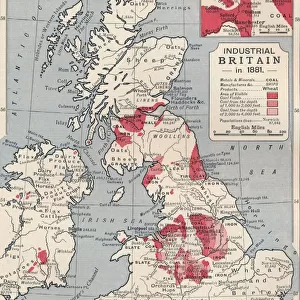
Photographic Print : Map of England in 1066


Photo Prints from North Wind
Map of England in 1066
England at the time of the Norman conquest, 1066-1081.
Color lithograph of a 19th-century illustration
North Wind Picture Archives brings history to life with stock images and hand-colored illustrations
Media ID 5879268
© North Wind Picture Archives
1066 11th Century Britain British England English Europe European Feudalism Great Britain Medieval Middle Ages Norman Norman Conquest Norman Invasion North Umberland Wales William The Conqueror Earldom
10"x8" Photo Print
Discover the rich history of England with our exquisite Media Storehouse Photographic Print of "Map of England in 1066" from North Wind Picture Archives. This captivating print showcases an intricately detailed 19th-century illustration of England during the Norman Conquest, from 1066 to 1081. Immerse yourself in the history of this pivotal period, as depicted in vibrant colors through lithography. Add this stunning piece to your home or office to inspire curiosity and spark conversations about the fascinating history of England.
Photo prints are produced on Kodak professional photo paper resulting in timeless and breath-taking prints which are also ideal for framing. The colors produced are rich and vivid, with accurate blacks and pristine whites, resulting in prints that are truly timeless and magnificent. Whether you're looking to display your prints in your home, office, or gallery, our range of photographic prints are sure to impress. Dimensions refers to the size of the paper in inches.
Our Photo Prints are in a large range of sizes and are printed on Archival Quality Paper for excellent colour reproduction and longevity. They are ideal for framing (our Framed Prints use these) at a reasonable cost. Alternatives include cheaper Poster Prints and higher quality Fine Art Paper, the choice of which is largely dependant on your budget.
Estimated Product Size is 20.3cm x 25.4cm (8" x 10")
These are individually made so all sizes are approximate
Artwork printed orientated as per the preview above, with landscape (horizontal) or portrait (vertical) orientation to match the source image.
FEATURES IN THESE COLLECTIONS
> North Wind Picture Archives
> British history
> North Wind Picture Archives
> Maps
> Arts
> Art Movements
> Medieval Art
> Europe
> United Kingdom
> England
> Maps
> Europe
> United Kingdom
> Maps
> Europe
> United Kingdom
> Wales
> Maps
> Europe
> United Kingdom
> Wales
> Posters
> Europe
> United Kingdom
> Wales
> Related Images
> Maps and Charts
> Related Images
> Maps and Charts
> Wales
EDITORS COMMENTS
This print showcases a remarkable piece of history - the Map of England in 1066, during the time of the Norman conquest. Created as a color lithograph in the 19th century, this illustration beautifully captures the essence of medieval England. The map takes us back to a bygone era, where kingdoms and earldoms dotted the landscape. It provides an intriguing glimpse into the political and geographical makeup of Great Britain at that time. From Northumberland to Wales, every region is meticulously depicted with intricate details. As we explore this vintage artwork, we can't help but feel connected to our heritage and traditions. The image evokes a sense of nostalgia for a past long gone yet still deeply ingrained within our cultural fabric. It reminds us of William the Conqueror's audacious invasion and subsequent Norman conquest that forever altered British history. This pivotal event marked not only a change in leadership but also introduced feudalism to these lands. Through this artful representation, we are transported back to an age characterized by castles, knights, and chivalry - an era known as the Middle Ages or Dark Ages. It serves as a visual reminder of how far Europe has come since then while honoring its rich historical tapestry. This stunning portrayal invites us to delve deeper into English history and appreciate how it shaped modern-day Britain. Whether displayed in homes or educational institutions, this print is sure to spark curiosity and ignite conversations about our shared past.
MADE IN THE USA
Safe Shipping with 30 Day Money Back Guarantee
FREE PERSONALISATION*
We are proud to offer a range of customisation features including Personalised Captions, Color Filters and Picture Zoom Tools
SECURE PAYMENTS
We happily accept a wide range of payment options so you can pay for the things you need in the way that is most convenient for you
* Options may vary by product and licensing agreement. Zoomed Pictures can be adjusted in the Cart.