Photographic Print > Europe > Russia > Maps
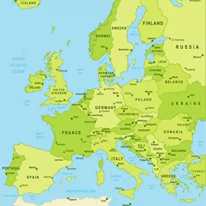
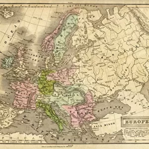
Photographic Print : Map of Europe, 1870s


![]()
Photo Prints from North Wind
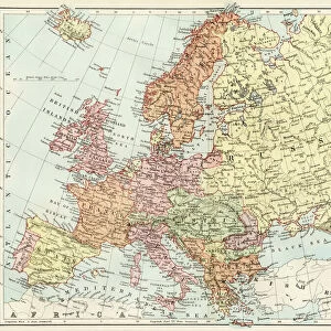
Map of Europe, 1870s
Map of Europe in the 1870s.
Color lithograph reproduction of a 19th-century illustration
North Wind Picture Archives brings history to life with stock images and hand-colored illustrations
Media ID 5882054
© North Wind Picture Archives
10"x8" Photo Print
Discover history through the lens of time with our exquisite selection of Photographic Prints from Media Storehouse, featuring this captivating Map of Europe from the 1870s. This beautifully restored color lithograph reproduction, sourced from the North Wind Picture Archives, transports you back in time, offering an intriguing glimpse into Europe's geopolitical landscape during the 19th century. Add a touch of historical charm to your home or office décor with this stunning, vintage print.
Photo prints are produced on Kodak professional photo paper resulting in timeless and breath-taking prints which are also ideal for framing. The colors produced are rich and vivid, with accurate blacks and pristine whites, resulting in prints that are truly timeless and magnificent. Whether you're looking to display your prints in your home, office, or gallery, our range of photographic prints are sure to impress. Dimensions refers to the size of the paper in inches.
Our Photo Prints are in a large range of sizes and are printed on Archival Quality Paper for excellent colour reproduction and longevity. They are ideal for framing (our Framed Prints use these) at a reasonable cost. Alternatives include cheaper Poster Prints and higher quality Fine Art Paper, the choice of which is largely dependant on your budget.
Estimated Product Size is 25.4cm x 20.3cm (10" x 8")
These are individually made so all sizes are approximate
Artwork printed orientated as per the preview above, with landscape (horizontal) or portrait (vertical) orientation to match the source image.
FEATURES IN THESE COLLECTIONS
> North Wind Picture Archives
> Maps
> Europe
> Russia
> Related Images
> Maps and Charts
> Related Images
EDITORS COMMENTS
This print showcases a remarkable piece of history - the Map of Europe in the 1870s. With its vibrant colors and intricate details, this color lithograph reproduction transports us back to a bygone era. The map itself is a testament to the rich heritage and traditional roots that define Europe. As we gaze upon this vintage illustration, our eyes are immediately drawn to Russia, which looms large on the map. Its vast expanse stretches across much of Eastern Europe, reminding us of its significant influence during this period. Surrounding countries such as Germany, France, Austria-Hungary, and Italy are also prominently featured with their distinct borders and territories. Every inch of this historic artwork tells a story about the political landscape and shifting alliances that characterized 19th-century Europe. It serves as an invaluable resource for historians and enthusiasts alike who seek to understand how nations evolved over time. The artistry behind this illustration is truly exceptional; it captures both accuracy and beauty simultaneously. The delicate lines and careful shading bring each country's shape to life while maintaining an overall sense of harmony within the composition. Whether you have an affinity for cartography or simply appreciate fine art from the 1800s, this Map of Europe from North Wind Picture Archives will undoubtedly captivate your imagination. Let it transport you back in time as you explore the intricacies of European history through this stunning visual representation.
MADE IN THE USA
Safe Shipping with 30 Day Money Back Guarantee
FREE PERSONALISATION*
We are proud to offer a range of customisation features including Personalised Captions, Color Filters and Picture Zoom Tools
SECURE PAYMENTS
We happily accept a wide range of payment options so you can pay for the things you need in the way that is most convenient for you
* Options may vary by product and licensing agreement. Zoomed Pictures can be adjusted in the Cart.