Photographic Print > Arts > Artists > P > Polynesian Polynesian
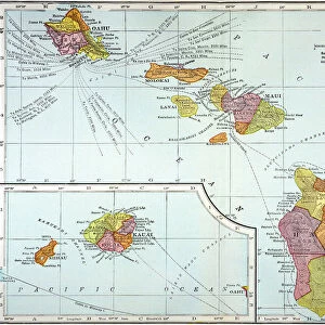
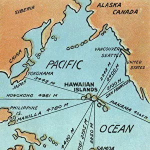
Photographic Print : Map of Hawaii, 1870s


![]()
Photo Prints from North Wind
Map of Hawaii, 1870s
Map of the Hawaiian islands, 1870s.
Color lithograph reproduction of a 19th-century illustration
North Wind Picture Archives brings history to life with stock images and hand-colored illustrations
Media ID 5882575
© North Wind Picture Archives
1870s Hawaii Hawaiian Hawaiian Islands Island Pacific Pacific Island Pacific Ocean Polynesia Polynesian Sandwich Islands
11"x8.5" Photo Print
Discover the rich history of Hawaii with our exquisite Media Storehouse Photographic Prints featuring a captivating map of the Hawaiian islands from the 1870s. This stunning, color lithograph reproduction brings to life the intricate details of this 19th-century illustration from North Wind Picture Archives. Transport yourself back in time and adorn your walls with this unique piece of history, perfect for history enthusiasts, travelers, or those who appreciate the beauty and culture of the islands. Add a touch of nostalgia and character to your space with our high-quality, museum-grade prints.
Photo prints are produced on Kodak professional photo paper resulting in timeless and breath-taking prints which are also ideal for framing. The colors produced are rich and vivid, with accurate blacks and pristine whites, resulting in prints that are truly timeless and magnificent. Whether you're looking to display your prints in your home, office, or gallery, our range of photographic prints are sure to impress. Dimensions refers to the size of the paper in inches.
Our Photo Prints are in a large range of sizes and are printed on Archival Quality Paper for excellent colour reproduction and longevity. They are ideal for framing (our Framed Prints use these) at a reasonable cost. Alternatives include cheaper Poster Prints and higher quality Fine Art Paper, the choice of which is largely dependant on your budget.
Estimated Image Size (if not cropped) is 27.9cm x 19.1cm (11" x 7.5")
Estimated Product Size is 27.9cm x 21.6cm (11" x 8.5")
These are individually made so all sizes are approximate
Artwork printed orientated as per the preview above, with landscape (horizontal) orientation to match the source image.
FEATURES IN THESE COLLECTIONS
> North Wind Picture Archives
> Maps
> Arts
> Artists
> O
> Oceanic Oceanic
> Arts
> Artists
> P
> Polynesian Polynesian
> Maps and Charts
> Related Images
> Popular Themes
> North Island
EDITORS COMMENTS
This print showcases a vibrant and historically significant "Map of Hawaii, 1870s". The color lithograph reproduction beautifully captures the essence of this 19th-century illustration, offering viewers a glimpse into the rich heritage and traditional roots of the Hawaiian islands. The map itself is an intricate depiction of the archipelago's geography, showcasing its position in the vast Pacific Ocean. It serves as a testament to Hawaii's unique place within Polynesia and its historical ties to both American and Polynesian cultures. With meticulous detail, this vintage artwork highlights various landmarks and regions that make up the Hawaiian islands. From lush green landscapes to sparkling blue waters, it transports us back in time to experience how these Pacific islands appeared during the late 1800s. As we explore this piece further, we can't help but appreciate its historical significance. It reminds us of Hawaii's journey from being known as Sandwich Islands to becoming an integral part of the United States' history. This artful representation invites us to delve deeper into Hawaiian history while also appreciating it as a work of art. Whether you are fascinated by cartography or simply drawn to vintage illustrations, this Map of Hawaii from North Wind Picture Archives is sure to captivate your imagination with its beauty and cultural importance.
MADE IN THE USA
Safe Shipping with 30 Day Money Back Guarantee
FREE PERSONALISATION*
We are proud to offer a range of customisation features including Personalised Captions, Color Filters and Picture Zoom Tools
SECURE PAYMENTS
We happily accept a wide range of payment options so you can pay for the things you need in the way that is most convenient for you
* Options may vary by product and licensing agreement. Zoomed Pictures can be adjusted in the Cart.