Photographic Print > Africa > Related Images
Photographic Print : Al-Idrisis world map, 1154


Photo Prints from Science Photo Library
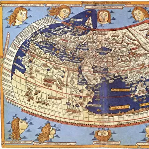
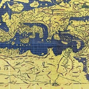
Al-Idrisis world map, 1154
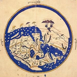
Al-Idrisis world map. This world map, known as the Tabula Rogeriana, dates from 1154, and is orientated with North at bottom. It was drawn by Muhammad Al-Idrisi (1100-1165), an Islamic and Andalusian scholar working for King Roger II of Sicily. It is considered to have been the most accurate world map for the next three centuries. Regions shown include Europe (lower right), the Mediterranean Sea (centre right), North Africa (upper right), the Arabian Peninsula (upper centre), the Black Sea and Caspian Sea (lower centre), and parts of Asia (left). This is a restoration and transliteration carried out in 1927 by the German scholar Konrad Miller (1844-1933)
Science Photo Library features Science and Medical images including photos and illustrations
Media ID 6297665
© LIBRARY OF CONGRESS, GEOGRAPHY AND MAP DIVISION/SCIENCE PHOTO LIBRARY
1100s 12th Century Africa African Andalusian Arabian Peninsula Arabic Black Sea Cartographic Cartography Caspian Sea Continent Continental German Global Islamic Italy Mediaeval Medieval Mediterranean Middle Ages Moslem Muslim North Africa Restoration Restored Seas Sicily Spanish Text World World Wide Writing 1154 King Of Sicily
11"x8.5" Photo Print
Discover the rich history of cartography with our stunning selection of Media Storehouse Photographic Prints featuring the Al-Idrisi World Map, also known as the Tabula Rogeriana. Dating back to 1154, this ancient masterpiece presents a unique and captivating perspective of the known world during the medieval Islamic Golden Age. Orientated with the north at the bottom, this exquisite map showcases intricate detail and accurate geographical information for Europe, Africa, and Asia. Bring a piece of history into your home or office with our high-quality photographic prints, perfect for inspiring curiosity and igniting conversations.
Photo prints are produced on Kodak professional photo paper resulting in timeless and breath-taking prints which are also ideal for framing. The colors produced are rich and vivid, with accurate blacks and pristine whites, resulting in prints that are truly timeless and magnificent. Whether you're looking to display your prints in your home, office, or gallery, our range of photographic prints are sure to impress. Dimensions refers to the size of the paper in inches.
Our Photo Prints are in a large range of sizes and are printed on Archival Quality Paper for excellent colour reproduction and longevity. They are ideal for framing (our Framed Prints use these) at a reasonable cost. Alternatives include cheaper Poster Prints and higher quality Fine Art Paper, the choice of which is largely dependant on your budget.
Estimated Image Size (if not cropped) is 27.9cm x 12.7cm (11" x 5")
Estimated Product Size is 27.9cm x 21.6cm (11" x 8.5")
These are individually made so all sizes are approximate
Artwork printed orientated as per the preview above, with landscape (horizontal) orientation to match the source image.
FEATURES IN THESE COLLECTIONS
> Africa
> Related Images
> Arts
> Art Movements
> Medieval Art
> Asia
> Related Images
> Europe
> Germany
> Related Images
> Europe
> Italy
> Sicily
> Related Images
> Europe
> Spain
> Related Images
> Maps and Charts
> Popular Maps
EDITORS COMMENTS
This print showcases the Al-Idrisis world map, also known as the Tabula Rogeriana, which was created in 1154. The mastermind behind this remarkable piece of cartography was Muhammad Al-Idrisi, a renowned Islamic and Andalusian scholar who served King Roger II of Sicily. What makes this map truly exceptional is its accuracy, making it the most reliable representation of the world for over three centuries. The photograph captures a restored version of the original map carried out by Konrad Miller, a German scholar, in 1927. It portrays various regions including Europe, with its distinctive shape nestled in the lower right corner; the Mediterranean Sea dominating the center-right portion; North Africa gracefully positioned towards the upper right side; and Asia extending to the left. As you delve into this artwork's intricate details, you can appreciate how it beautifully combines geography and history. The text accompanying each region provides valuable insights into different cultures and civilizations during that era. This particular restoration highlights both African and Asian influences on medieval European knowledge. With North placed at bottom rather than top – an unconventional orientation – this map challenges traditional perspectives while offering a unique visual experience. Its significance lies not only in its historical value but also as an artistic masterpiece that seamlessly blends scientific accuracy with aesthetic appeal. In summary, this mesmerizing print immortalizes Al-Idrisis' groundbreaking work from centuries ago—a testament to his genius as well as an enduring symbol of cross-cultural exchange between diverse societies throughout history.
MADE IN THE USA
Safe Shipping with 30 Day Money Back Guarantee
FREE PERSONALISATION*
We are proud to offer a range of customisation features including Personalised Captions, Color Filters and Picture Zoom Tools
SECURE PAYMENTS
We happily accept a wide range of payment options so you can pay for the things you need in the way that is most convenient for you
* Options may vary by product and licensing agreement. Zoomed Pictures can be adjusted in the Cart.