Photographic Print > Arts > Artists > A > Battista Agnese
Photographic Print : Europe, 16th century nautical map


![]()
Photo Prints from Science Photo Library
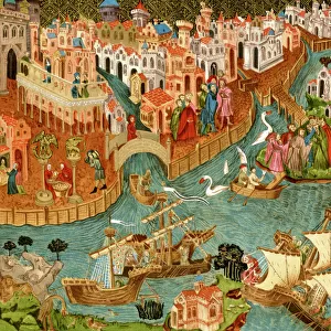
Europe, 16th century nautical map
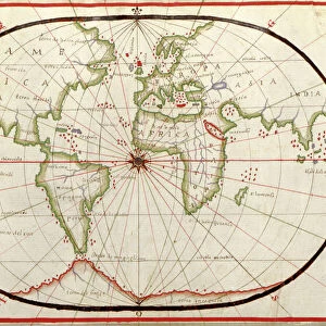
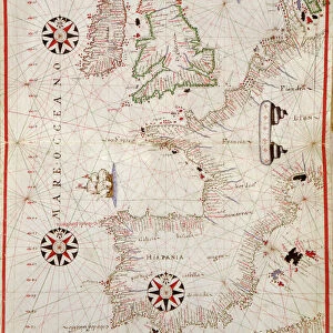
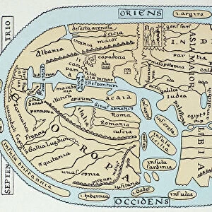
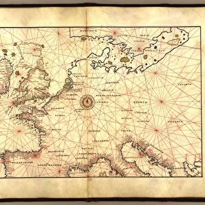
Nautical map of Europe, 1544 copy of Agnese Atlas. Several copies of this atlas were produced between 1536 and 1564, in Venice, by the Italian mapmaker Battista Agnese. The red lines crossing the map (thumb lines) centre on the compass rose at centre of the map, and are used to show distances between points on the map. As a nautical map, only details of the Mediterranean and Western European coasts are shown. The north and Baltic Sea coasts are not labelled. The Baltic coasts and British Isles are not mapped accurately. This edition of the atlas was dedicated to Hieronymus Ruffault, Abbot of St Vst, Arras, France. It eventually reached the US Library of Congress in 1943
Science Photo Library features Science and Medical images including photos and illustrations
Media ID 1699823
© LIBRARY OF CONGRESS/SCIENCE PHOTO LIBRARY
1500s 16th Century Ancient Atlas Book Cartography Coast Coastal Coasts Continent Diagram Inaccurate Italian Nautical Renaissance 1544 Library Of Congress
10"x8" Photo Print
Discover the rich history of European maritime exploration with our exquisite selection of Photographic Prints from the Media Storehouse. This captivating print showcases a rare and intriguing 16th-century nautical map, hailing from the Agnese Atlas created by Italian mapmaker Battista Agnese between 1536 and 1564. With intricate detail and vibrant colors, this nautical chart brings the ancient world to life. Perfect for history enthusiasts, cartography collectors, and those who appreciate the beauty of historical art, our Photographic Prints make a striking addition to any home or office space. Relive the tales of brave seafarers and the exciting discoveries of a bygone era.
Photo prints are produced on Kodak professional photo paper resulting in timeless and breath-taking prints which are also ideal for framing. The colors produced are rich and vivid, with accurate blacks and pristine whites, resulting in prints that are truly timeless and magnificent. Whether you're looking to display your prints in your home, office, or gallery, our range of photographic prints are sure to impress. Dimensions refers to the size of the paper in inches.
Our Photo Prints are in a large range of sizes and are printed on Archival Quality Paper for excellent colour reproduction and longevity. They are ideal for framing (our Framed Prints use these) at a reasonable cost. Alternatives include cheaper Poster Prints and higher quality Fine Art Paper, the choice of which is largely dependant on your budget.
Estimated Image Size (if not cropped) is 25.4cm x 17.7cm (10" x 7")
Estimated Product Size is 25.4cm x 20.3cm (10" x 8")
These are individually made so all sizes are approximate
Artwork printed orientated as per the preview above, with landscape (horizontal) orientation to match the source image.
FEATURES IN THESE COLLECTIONS
> Animals
> Mammals
> Muridae
> Western Mediterranean Mouse
> Animals
> Mammals
> Muridae
> Western Mouse
> Arts
> Art Movements
> Renaissance Art
> Arts
> Artists
> A
> Battista Agnese
> Europe
> Italy
> Veneto
> Venice
> Europe
> Related Images
> Europe
> United Kingdom
> Scotland
> Western Isles
> Related Images
> Science Photo Library
> History
EDITORS COMMENTS
This print showcases a remarkable piece of history - a 16th century nautical map of Europe. Created in 1544 by the renowned Italian mapmaker Battista Agnese, this particular copy is from the esteemed Agnese Atlas. Produced between 1536 and 1564 in Venice, these atlases were highly sought after during the Renaissance period. The intricate details of this ancient map are truly awe-inspiring. The red lines that crisscross the map, known as thumb lines, converge on the compass rose at its center. These lines serve to indicate distances between various points on the map, providing valuable navigational information for seafarers. As a nautical map, it primarily focuses on depicting accurate coastlines of the Mediterranean and Western European regions. However, it should be noted that both Baltic Sea coasts and British Isles are not accurately mapped in this edition. Dedicated to Hieronymus Ruffault, Abbot of St Vst in Arras, France, this particular edition eventually found its way to the prestigious US Library of Congress in 1943. Its presence there serves as a testament to its historical significance and enduring value. This photograph offers us an extraordinary glimpse into centuries past - an exquisite blend of artistry and cartography that transports us back to a time when exploration was still unfolding across uncharted seas.
MADE IN THE USA
Safe Shipping with 30 Day Money Back Guarantee
FREE PERSONALISATION*
We are proud to offer a range of customisation features including Personalised Captions, Color Filters and Picture Zoom Tools
SECURE PAYMENTS
We happily accept a wide range of payment options so you can pay for the things you need in the way that is most convenient for you
* Options may vary by product and licensing agreement. Zoomed Pictures can be adjusted in the Cart.