Photographic Print > Africa > Related Images
Photographic Print : Map of the world, 1720


![]()
Photo Prints from Science Photo Library
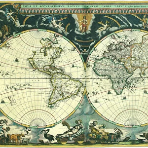
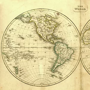
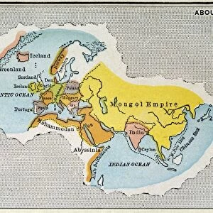
Map of the world, 1720
18th century map of the world. Published in Paris in 1720, this French map shows the known world, including the new lands that had been discovered in the preceding centuries by Europeans exploring across the Atlantic and far to the East around Africa. It divides the Earth into a western and eastern hemisphere, and uses colour to mark different areas of land. The map is by Guillaume de l Isle (1675-1726), the leading French cartographer of the eighteenth century. He was appointed Premier Geographe du Roi to King Louis XV in 1718. This edition of his world map includes the western and northern coastlines of Australia, mapped by the Dutch. Australias eastern coastline would not be mapped until 1770
Science Photo Library features Science and Medical images including photos and illustrations
Media ID 6368365
© LIBRARY OF CONGRESS, GEOGRAPHY AND MAP DIVISION/SCIENCE PHOTO LIBRARY
1700s 1720 18th Century Age Of Discovery Cartography Colonies Colony Continent Continental Continents Dutch Empire Eurasian Exploration French Medieval Middle Ages New World North American Old World South American Spanish World Guillaume De Lisle
11"x8.5" Photo Print
Step back in time with our exquisite selection from the Media Storehouse range of Historical Photographic Prints. This captivating image, "Map of the World, 1720" by Science Photo Library, takes you on a journey to the 18th century. Published in Paris in 1720, this beautifully detailed map showcases the known world as it was understood at the time, including newly discovered lands from European exploration. A stunning addition to any decor or office space, this print is not only a work of art but also a piece of history. Let the past come alive in your home or workplace with our Media Storehouse Historical Photographic Prints.
Photo prints are produced on Kodak professional photo paper resulting in timeless and breath-taking prints which are also ideal for framing. The colors produced are rich and vivid, with accurate blacks and pristine whites, resulting in prints that are truly timeless and magnificent. Whether you're looking to display your prints in your home, office, or gallery, our range of photographic prints are sure to impress. Dimensions refers to the size of the paper in inches.
Our Photo Prints are in a large range of sizes and are printed on Archival Quality Paper for excellent colour reproduction and longevity. They are ideal for framing (our Framed Prints use these) at a reasonable cost. Alternatives include cheaper Poster Prints and higher quality Fine Art Paper, the choice of which is largely dependant on your budget.
Estimated Image Size (if not cropped) is 27.9cm x 18.8cm (11" x 7.4")
Estimated Product Size is 27.9cm x 21.6cm (11" x 8.5")
These are individually made so all sizes are approximate
Artwork printed orientated as per the preview above, with landscape (horizontal) orientation to match the source image.
FEATURES IN THESE COLLECTIONS
> Africa
> Related Images
> Asia
> Related Images
> Europe
> France
> Paris
> Related Images
> Europe
> Spain
> Related Images
> Oceania
> Australia
> Related Images
> South America
> Related Images
EDITORS COMMENTS
This print showcases a remarkable piece of history - a map of the world from 1720. Published in Paris, this French map represents the known world during the 18th century, incorporating newly discovered lands by European explorers across the Atlantic and around Africa. Created by Guillaume de l'Isle, one of the leading cartographers of his time, this edition divides Earth into western and eastern hemispheres while utilizing vibrant colors to distinguish different areas of land. Notably, this map includes the western and northern coastlines of Australia as mapped by Dutch explorers. However, it is interesting to note that Australia's eastern coastline would not be accurately depicted until 1770 when Captain James Cook charted its shores. This historical artifact provides us with a glimpse into an era characterized by colonialism and exploration. The intricate details on this map offer insights into various continents such as Asia, Europe, North America, South America, and more. It serves as a testament to centuries-old geographical knowledge and sheds light on how our understanding of the world has evolved over time. As we admire this snapshot from history captured by Science Photo Library without commercial intentions or affiliations mentioned here), we are reminded of humanity's insatiable curiosity for discovery and our ongoing quest to unravel the mysteries that lie beyond our horizons.
MADE IN THE USA
Safe Shipping with 30 Day Money Back Guarantee
FREE PERSONALISATION*
We are proud to offer a range of customisation features including Personalised Captions, Color Filters and Picture Zoom Tools
SECURE PAYMENTS
We happily accept a wide range of payment options so you can pay for the things you need in the way that is most convenient for you
* Options may vary by product and licensing agreement. Zoomed Pictures can be adjusted in the Cart.