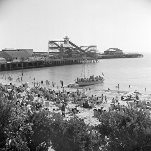
Photographic Print > Europe > United Kingdom > England > Essex > Clacton on Sea
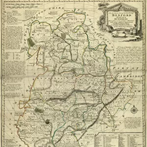
Photographic Print : County Map of Essex, c. 1777


![]()
Photo Prints from Sheffield City Archives
County Map of Essex, c. 1777
From The Large English Atlas: or, a new set of map of all the counties of England and Wales drawn from the several surveys which have been hitherto been published. With three general maps of England, Scotland and Ireland, from the latest and best authorities, by Emanuel Bowen, Thomas Kitchin and others. London, printed and sold by T. Bowles, [c.1777]
Original at Sheffield Libraries: 912 STF
Sheffield City Archives and Local Studies Library has an unrivalled collection of images of Sheffield, England
Media ID 25441080
© Sheffield City Council - All Rights Reserved
Antique Map Bowens Map County Map Emanuel Bowen Old Map Thomas Kitchin Basildon Billericay Braintree Brentwood Chelmsford Chigwell Clacton On Sea Colchester Epping Essex Grays Halstead Harlow Harwich Loughton Maldon Rayleigh Rochford Saffron Walden Southend On Sea Tilbury Waltham Abbey Walton On The Naze Witham
10"x8" Photo Print
Discover the rich history of Essex with our exquisite Media Storehouse Photographic Print of a County Map from The Large English Atlas, dated back to 1777. This stunning antique map, sourced from Sheffield City Archives, takes you on a journey through time, showcasing the layout of Essex over 245 years ago. The intricate details and authenticity of this print make it a must-have for history enthusiasts, collectors, and those who appreciate the beauty of vintage cartography. Bring a piece of the past into your home or office with this unique and captivating photographic print.
Photo prints are produced on Kodak professional photo paper resulting in timeless and breath-taking prints which are also ideal for framing. The colors produced are rich and vivid, with accurate blacks and pristine whites, resulting in prints that are truly timeless and magnificent. Whether you're looking to display your prints in your home, office, or gallery, our range of photographic prints are sure to impress. Dimensions refers to the size of the paper in inches.
Our Photo Prints are in a large range of sizes and are printed on Archival Quality Paper for excellent colour reproduction and longevity. They are ideal for framing (our Framed Prints use these) at a reasonable cost. Alternatives include cheaper Poster Prints and higher quality Fine Art Paper, the choice of which is largely dependant on your budget.
Estimated Product Size is 25.4cm x 20.3cm (10" x 8")
These are individually made so all sizes are approximate
Artwork printed orientated as per the preview above, with landscape (horizontal) or portrait (vertical) orientation to match the source image.
FEATURES IN THESE COLLECTIONS
> Europe
> United Kingdom
> England
> Essex
> Clacton on Sea
> Europe
> United Kingdom
> England
> Essex
> Southend on Sea
> Europe
> United Kingdom
> England
> Essex
> Walton on the Naze
> Sheffield City Archives
> Maps and Plans
> Bowen's County Maps, c. 1777
EDITORS COMMENTS
This print showcases a County Map of Essex, dating back to approximately 1777. Extracted from "The Large English Atlas: or, a new set of map of all the counties of England and Wales" this antique map is an invaluable piece of historical cartography. Crafted by eminent cartographers Emanuel Bowen, Thomas Kitchin, and others, it offers a comprehensive depiction of Essex's geographical features during that era. With intricate details and precision, the map highlights prominent towns such as Southend-on-Sea, Colchester, Chelmsford, Basildon, Rayleigh, and South Benfleet. It also encompasses lesser-known areas like Thunderley, Harlow, Grays, Brentwood Clacton-on-Sea. The inclusion of smaller locales such as Braintree, Canvey Island, Billericay, Wickford, Loughton, Stanford-le-Hope, Witham, Maldon, Harwich adds depth to its representation. From Waltham Abbey to Rochford and Saffron Walden to Tilbury—each place finds its rightful spot on this historic document. Notably absent are any references to commercial use or the company associated with it. Preserved at Sheffield Libraries within their esteemed collection (912 STF), this remarkable print allows us to trace our roots back in time while marveling at the meticulous craftsmanship employed by these gifted cartographers. Whether you have ancestral ties or simply appreciate historical maps' allure—the County Map of Essex
MADE IN THE USA
Safe Shipping with 30 Day Money Back Guarantee
FREE PERSONALISATION*
We are proud to offer a range of customisation features including Personalised Captions, Color Filters and Picture Zoom Tools
SECURE PAYMENTS
We happily accept a wide range of payment options so you can pay for the things you need in the way that is most convenient for you
* Options may vary by product and licensing agreement. Zoomed Pictures can be adjusted in the Cart.