Photographic Print > Universal Images Group (UIG) > Art > Painting, Sculpture & Prints > Illustration And Painting
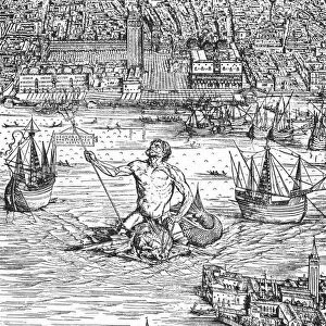
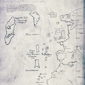
Photographic Print : Map of Venice in 1500, by Jacopo de Barbari


![]()
Photo Prints from Universal Images Group (UIG)
Map of Venice in 1500, by Jacopo de Barbari
Cartography, Italy, 16th century. Map of Venice in 1500, by Jacopo de Barbari
Universal Images Group (UIG) manages distribution for many leading specialist agencies worldwide
Media ID 9505423
© DEA / A. DAGLI ORTI
16th Century City Map Cityscape Lagoon Panoramic Venice Jacopo De Barbari
11"x8.5" Photo Print
Discover the rich history and intricate detail of the past with our exquisite selection of Photographic Prints from Media Storehouse. This particular print showcases a breathtaking map of Venice in 1500, created by the renowned Italian cartographer Jacopo de Barbari. This masterpiece, sourced from Universal Images Group (UIG), transports you back in time to the 16th century, offering an unparalleled glimpse into the urban layout and grandeur of one of the world's most iconic cities. Bring the captivating allure of Venice into your home or office and elevate your space with this stunning work of art.
Photo prints are produced on Kodak professional photo paper resulting in timeless and breath-taking prints which are also ideal for framing. The colors produced are rich and vivid, with accurate blacks and pristine whites, resulting in prints that are truly timeless and magnificent. Whether you're looking to display your prints in your home, office, or gallery, our range of photographic prints are sure to impress. Dimensions refers to the size of the paper in inches.
Our Photo Prints are in a large range of sizes and are printed on Archival Quality Paper for excellent colour reproduction and longevity. They are ideal for framing (our Framed Prints use these) at a reasonable cost. Alternatives include cheaper Poster Prints and higher quality Fine Art Paper, the choice of which is largely dependant on your budget.
Estimated Image Size (if not cropped) is 27.9cm x 13.5cm (11" x 5.3")
Estimated Product Size is 27.9cm x 21.6cm (11" x 8.5")
These are individually made so all sizes are approximate
Artwork printed orientated as per the preview above, with landscape (horizontal) orientation to match the source image.
EDITORS COMMENTS
This stunning panoramic print showcases the intricate and detailed "Map of Venice in 1500" by renowned cartographer Jacopo de Barbari. A true masterpiece of Italian cartography from the 16th century, this antique map offers a captivating glimpse into the rich history and geography of Venice. With its horizontal layout, this illustration and painting beautifully captures the sprawling cityscape of Venice, depicting its labyrinthine canals, charming bridges, and magnificent architecture. The absence of people allows us to focus solely on the architectural marvels that make up this enchanting city. Jacopo de Barbari's meticulous attention to detail is evident as he skillfully portrays every nook and cranny of Venice's lagoon. From St. Mark's Square to Rialto Bridge, each landmark is meticulously rendered with precision and accuracy. As we explore this historical artifact, it transports us back in time to an era when gondolas glided through these very canals while merchants traded goods along bustling marketplaces. It serves as a testament to both Venetian ingenuity in urban planning and Jacopo de Barbari's artistic prowess. Whether you are a history enthusiast or simply captivated by beautiful illustrations, this print offers a unique window into one of Italy's most iconic cities during its golden age. Displayed proudly on any wall or study desk, it invites you to immerse yourself in centuries-old tales woven within the fabric of Venice itself.
MADE IN THE USA
Safe Shipping with 30 Day Money Back Guarantee
FREE PERSONALISATION*
We are proud to offer a range of customisation features including Personalised Captions, Color Filters and Picture Zoom Tools
SECURE PAYMENTS
We happily accept a wide range of payment options so you can pay for the things you need in the way that is most convenient for you
* Options may vary by product and licensing agreement. Zoomed Pictures can be adjusted in the Cart.