Pillow > Fine Art Finder > Maps (celestial & Terrestrial)
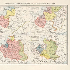
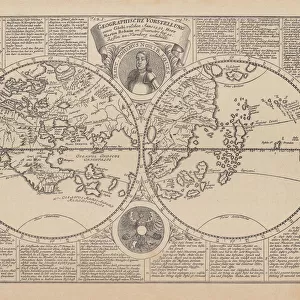
Pillow : Scandinavia, detail from the Carta Marina da Olaus Magnus, 1572 (coloured engraving)
")
")

![]()
Home Decor from Fine Art Finder
Scandinavia, detail from the Carta Marina da Olaus Magnus, 1572 (coloured engraving)
XIR155549 Scandinavia, detail from the Carta Marina da Olaus Magnus, 1572 (coloured engraving) by Lafreri, Antonio (1512-77); Institut Tessin, Hotel de Marle, Paris, France; French, out of copyright
Media ID 12731063
© www.bridgemanimages.com
Atlas Baltic Sea Denmark Estonia Finland Gotland Latvia Lithuania North Sea Northern Europe Norway States Territorial Gulf Of Bothnia
18"x18" (46x46cm) Pillow
18"x18" (46x46cm) Faux Suede Pillow with a plush soft feel. Your choice of image fills the front, with a stone colored faux suede back. Flat sewn concealed white zip.
Accessorise your space with decorative, soft pillows
Estimated Product Size is 45.7cm x 45.7cm (18" x 18")
These are individually made so all sizes are approximate
Artwork printed orientated as per the preview above, with landscape (horizontal) or portrait (vertical) orientation to match the source image.
FEATURES IN THESE COLLECTIONS
> Fine Art Finder
> Artists
> Antonio Lafreri
> Fine Art Finder
> Maps (celestial & Terrestrial)
EDITORS COMMENTS
This print showcases a stunning detail from the Carta Marina da Olaus Magnus, an exquisite coloured engraving created by Antonio Lafreri in 1572. The print is currently housed at the Institut Tessin, Hotel de Marle in Paris, France. The image depicts Scandinavia, a region known for its breathtaking landscapes and rich cultural heritage. Stretching across Northern Europe, this detailed map encompasses Denmark, Norway, Finland, Estonia, Latvia, Lithuania and even includes islands like Gotland. With intricate precision and vibrant colors that have stood the test of time since it is out of copyright now; this historical artwork provides us with valuable insights into European history and territorial boundaries during the 16th century. From the majestic North Sea to the serene Baltic Sea and Gulf of Bothnia - every coastal feature is meticulously depicted on this map. It offers a glimpse into how these countries were interconnected through trade routes and maritime activities centuries ago. As we admire this remarkable piece of artistry captured by Fine Art Finder's lens at www. bridgemanimages. com , let us appreciate not only its aesthetic beauty but also its significance as a testament to our shared human history.
MADE IN THE USA
Safe Shipping with 30 Day Money Back Guarantee
FREE PERSONALISATION*
We are proud to offer a range of customisation features including Personalised Captions, Color Filters and Picture Zoom Tools
SECURE PAYMENTS
We happily accept a wide range of payment options so you can pay for the things you need in the way that is most convenient for you
* Options may vary by product and licensing agreement. Zoomed Pictures can be adjusted in the Cart.