Pillow > Asia > Georgia > Maps
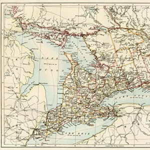
Pillow : Geographic map of European claims on North American territories in 1733 when the last colony, Georgia was founded. Description of the borders of the territories under French, Spanish and British domination and of the lands still unexploded


![]()
Home Decor from Fine Art Finder
Geographic map of European claims on North American territories in 1733 when the last colony, Georgia was founded. Description of the borders of the territories under French, Spanish and British domination and of the lands still unexploded
NWI4853381 Geographic map of European claims on North American territories in 1733 when the last colony, Georgia was founded. Description of the borders of the territories under French, Spanish and British domination and of the lands still unexploded. Color lithograph of the 19th century.; (add.info.: Geographic map of European claims on North American territories in 1733 when the last colony, Georgia was founded. Description of the borders of the territories under French, Spanish and British domination and of the lands still unexploded. Color lithograph of the 19th century.); Photo © North Wind Pictures
Media ID 38266722
© © North Wind Pictures / Bridgeman Images
18"x18" (46x46cm) Pillow
18"x18" (46x46cm) Faux Suede Pillow with a plush soft feel. Your choice of image fills the front, with a stone colored faux suede back. Flat sewn concealed white zip.
Accessorise your space with decorative, soft pillows
Estimated Product Size is 45.7cm x 45.7cm (18" x 18")
These are individually made so all sizes are approximate
Artwork printed orientated as per the preview above, with landscape (horizontal) or portrait (vertical) orientation to match the source image.
FEATURES IN THESE COLLECTIONS
> Fine Art Finder
> Artists
> Artist Unknown
> Asia
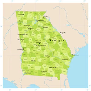
> Georgia
> Related Images
> Europe
> Spain
> Related Images
> Maps and Charts
> Early Maps
> Maps and Charts
> Related Images
EDITORS COMMENTS
This historical lithograph from the 19th century showcases a detailed Geographic map of European claims on North American territories in 1733, marking a pivotal moment with the founding of the last colony, Georgia. The borders of French, Spanish, and British domination are clearly delineated, illustrating the complex web of colonial power dynamics during this period.
The vibrant colors used in this print bring to life the territorial divisions that were fiercely contested by these European powers. The lands still unexplored hint at the vast expanse of unknown territory waiting to be claimed and colonized.
As we gaze upon this map, we are transported back in time to an era when nations vied for control over new lands and resources across the Atlantic. It serves as a visual reminder of the impact of colonization on indigenous peoples and cultures that inhabited these regions long before European arrival.
This image is not just a snapshot of history but a testament to the enduring legacy of colonialism in shaping the geopolitical landscape of North America. It invites us to reflect on our shared past and consider how it continues to influence our present-day relationships with land, power, and identity.
MADE IN THE USA
Safe Shipping with 30 Day Money Back Guarantee
FREE PERSONALISATION*
We are proud to offer a range of customisation features including Personalised Captions, Color Filters and Picture Zoom Tools
SECURE PAYMENTS
We happily accept a wide range of payment options so you can pay for the things you need in the way that is most convenient for you
* Options may vary by product and licensing agreement. Zoomed Pictures can be adjusted in the Cart.