Pillow > Asia > Bhutan > Maps
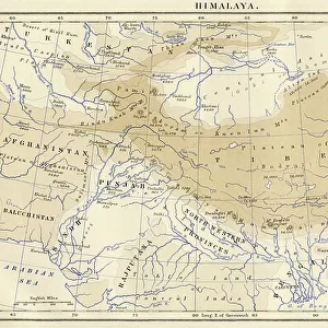
Pillow : Map of Burmah and the Adjacent Countries (engraving)
")
")

![]()
Home Decor from Fine Art Finder
Map of Burmah and the Adjacent Countries (engraving)
1614297 Map of Burmah and the Adjacent Countries (engraving) by English School, (19th century); Private Collection; (add.info.: Map of Burmah and the Adjacent Countries. Illustration for The Illustrated London News, 24 October 1885.
English School (19th Century)); Look and Learn / Illustrated Papers Collection
Media ID 22853658
© Look and Learn / Illustrated Papers Collection / Bridgeman Images
Bhutan Burma Burmah Buthan Tibet
18"x18" (46x46cm) Pillow
18"x18" (46x46cm) Faux Suede Pillow with a plush soft feel. Your choice of image fills the front, with a stone colored faux suede back. Flat sewn concealed white zip.
Accessorise your space with decorative, soft pillows
Estimated Product Size is 45.7cm x 45.7cm (18" x 18")
These are individually made so all sizes are approximate
Artwork printed orientated as per the preview above, with landscape (horizontal) or portrait (vertical) orientation to match the source image.
FEATURES IN THESE COLLECTIONS
> Asia
> Bhutan
> Related Images
> Asia
> Myanmar
> Related Images
> Maps and Charts
> Related Images
EDITORS COMMENTS
This engraving titled "Map of Burmah and the Adjacent Countries" takes us back to the 19th century, offering a glimpse into the intricate cartography of that era. The map showcases not only Burma but also its neighboring countries, including Bhutan and Tibet, unveiling the rich tapestry of Asia's diverse landscapes. Created by an anonymous English School artist, this print was originally featured in The Illustrated London News on October 24,1885. Its inclusion in this renowned publication speaks to its significance as a valuable source of information during that time. The meticulous details etched onto this map allow us to explore the vast territories it covers. From mountain ranges to rivers and coastlines, every element is meticulously depicted with precision and accuracy. It serves as a testament to both the artistry and scientific approach employed by cartographers centuries ago. As we gaze upon this historical artifact today, we are reminded of how maps have always been essential tools for exploration and understanding our world. This particular piece offers a window into an era when knowledge about distant lands was limited yet eagerly sought after. Preserved within a private collection, this engraving continues to captivate viewers with its beauty and historical significance. It stands as a reminder of our shared human curiosity about far-off places and our relentless pursuit of knowledge throughout history.
MADE IN THE USA
Safe Shipping with 30 Day Money Back Guarantee
FREE PERSONALISATION*
We are proud to offer a range of customisation features including Personalised Captions, Color Filters and Picture Zoom Tools
SECURE PAYMENTS
We happily accept a wide range of payment options so you can pay for the things you need in the way that is most convenient for you
* Options may vary by product and licensing agreement. Zoomed Pictures can be adjusted in the Basket.