Pillow > Arts > Artists > W > Frederick de Wit
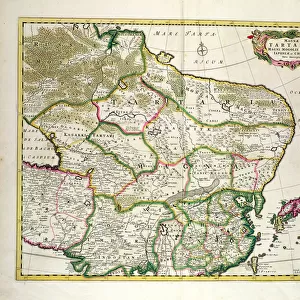
Pillow : Map of the Duche of Gelderland and the Count of Zutphen (Germany) (etching, 1671)
 (etching, 1671)")

 (etching, 1671)")

![]()
Home Decor from Fine Art Finder
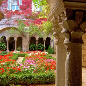
Map of the Duche of Gelderland and the Count of Zutphen (Germany) (etching, 1671)
LRI4710846 Map of the Duche of Gelderland and the Count of Zutphen (Germany) (etching, 1671) by Wit, Frederick de (1630-1706); Private Collection; (add.info.: Map of the Duche of Gelderland and the Count of Zutphen (Germany) - Strong water extracted from " Theatrum Orbis", 1671, by Frederick De Wit (Frederico de Witt) (1630-1706)); Luisa Ricciarini; Dutch, out of copyright
Media ID 22467846
© Luisa Ricciarini / Bridgeman Images
18"x18" (46x46cm) Pillow
18"x18" (46x46cm) Faux Suede Pillow with a plush soft feel. Your choice of image fills the front, with a stone colored faux suede back. Flat sewn concealed white zip.
Accessorise your space with decorative, soft pillows
Estimated Product Size is 45.7cm x 45.7cm (18" x 18")
These are individually made so all sizes are approximate
Artwork printed orientated as per the preview above, with landscape (horizontal) or portrait (vertical) orientation to match the source image.
FEATURES IN THESE COLLECTIONS
> Fine Art Finder
> Artists
> Frederick de Wit
> Arts
> Artists
> W
> Frederick de Wit
> Maps and Charts
> Related Images
EDITORS COMMENTS
This print showcases a historical etching from 1671, titled "Map of the Duche of Gelderland and the Count of Zutphen (Germany)" by Frederick de Wit. The intricate details and precision in this map transport us back to a time when cartography was both an art form and a scientific endeavor. The etching depicts the Duchy of Gelderland and the County of Zutphen, two regions located in present-day Germany. It is extracted from "Theatrum Orbis" a renowned atlas book published by De Wit himself. With strong water extraction techniques, De Wit masterfully captures the geography and topography of these territories. As we delve into this piece, we are reminded of how maps were not only practical tools for navigation but also works that conveyed power dynamics between different regions. The borders meticulously outlined on this map symbolize political boundaries during that era. Luisa Ricciarini's skillful photography allows us to appreciate every minute detail within this engraving. Through her lens, we can observe the delicate lines and shading that bring life to rivers, mountains, cities, and forests depicted on this historic map. This print serves as a testament to both artistic craftsmanship and historical significance. It invites us to explore the past through cartographic artistry while appreciating its aesthetic beauty.
MADE IN THE USA
Safe Shipping with 30 Day Money Back Guarantee
FREE PERSONALISATION*
We are proud to offer a range of customisation features including Personalised Captions, Color Filters and Picture Zoom Tools
SECURE PAYMENTS
We happily accept a wide range of payment options so you can pay for the things you need in the way that is most convenient for you
* Options may vary by product and licensing agreement. Zoomed Pictures can be adjusted in the Cart.