Pillow > Europe > France > Heritage Sites > Palace and Park of Versailles
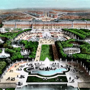
Pillow : Plan of Versailles, France in 1789. From Historical Atlas, published 1923 (print)
")
")

![]()
Home Decor from Fine Art Finder
Plan of Versailles, France in 1789. From Historical Atlas, published 1923 (print)
2603518 Plan of Versailles, France in 1789. From Historical Atlas, published 1923 (print)
Media ID 38504812
© Bridgeman Images
1789 18th Capital Chart Countries Eighteenth Geographical Versailles
18"x18" (46x46cm) Pillow
18"x18" (46x46cm) Faux Suede Pillow with a plush soft feel. Your choice of image fills the front, with a stone colored faux suede back. Flat sewn concealed white zip.
Accessorise your space with decorative, soft pillows
Estimated Product Size is 45.7cm x 45.7cm (18" x 18")
These are individually made so all sizes are approximate
Artwork printed orientated as per the preview above, with landscape (horizontal) or portrait (vertical) orientation to match the source image.
FEATURES IN THESE COLLECTIONS
> Fine Art Finder
> Artists
> Italian Photographer
> Europe
> France
> Heritage Sites
> Palace and Park of Versailles
> Maps and Charts
> Early Maps
> Maps and Charts
> Related Images
EDITORS COMMENTS
This stunning print captures the intricate and detailed Plan of Versailles, France in 1789. Published in a Historical Atlas in 1923, this map provides a glimpse into the layout and design of one of Europe's most iconic palaces.
Versailles, known for its opulent architecture and vast gardens, served as the royal residence of French monarchs during the 18th century. This map showcases the grandeur and scale of the palace complex, with its symmetrical layout and expansive grounds.
The vibrant colors used in this print bring to life the beauty and elegance of Versailles, highlighting its importance as both a political capital and cultural center in France. The careful attention to detail in this map reflects the meticulous planning that went into creating such a magnificent architectural masterpiece.
As you study this map, you can imagine walking through the halls of Versailles, admiring its ornate decorations and lush surroundings. It serves as a reminder of France's rich history and legacy as a leader in art, architecture, and culture.
Whether you are a history buff or simply appreciate fine craftsmanship, this print is sure to captivate your imagination and transport you back to the splendor of 18th century Versailles.
MADE IN THE USA
Safe Shipping with 30 Day Money Back Guarantee
FREE PERSONALISATION*
We are proud to offer a range of customisation features including Personalised Captions, Color Filters and Picture Zoom Tools
SECURE PAYMENTS
We happily accept a wide range of payment options so you can pay for the things you need in the way that is most convenient for you
* Options may vary by product and licensing agreement. Zoomed Pictures can be adjusted in the Cart.