Pillow > Europe > Serbia > Maps
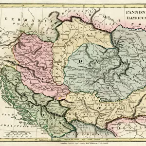
Pillow : Geographic map of Serbia in the 1870s. 19th century colour lithography


![]()
Home Decor from Fine Art Finder
Geographic map of Serbia in the 1870s. 19th century colour lithography
NWI4871115 Geographic map of Serbia in the 1870s. 19th century colour lithography; (add.info.: Geographic map of Serbia in the 1870s. 19th century colour lithography); Photo © North Wind Pictures
Media ID 38267300
© © North Wind Pictures / Bridgeman Images
Serbia Serbian Serbs Geographical Map
18"x18" (46x46cm) Pillow
18"x18" (46x46cm) Faux Suede Pillow with a plush soft feel. Your choice of image fills the front, with a stone colored faux suede back. Flat sewn concealed white zip.
Accessorise your space with decorative, soft pillows
Estimated Product Size is 45.7cm x 45.7cm (18" x 18")
These are individually made so all sizes are approximate
Artwork printed orientated as per the preview above, with landscape (horizontal) or portrait (vertical) orientation to match the source image.
FEATURES IN THESE COLLECTIONS
> Fine Art Finder
> Artists
> Pasquier (workshop of) Grenier
> Europe
> Serbia
> Related Images
> Maps and Charts
> Early Maps
> Maps and Charts
> Related Images
EDITORS COMMENTS
This stunning print of a Geographic map of Serbia from the 1870s captures the intricate details and vibrant colors of 19th-century lithography. The map showcases the geographical layout of Serbia, providing a glimpse into the country's borders, cities, and topographical features during this historical period.
The rich hues and fine lines in this print bring to life the essence of 19th-century cartography, showcasing the artistry and precision that went into creating such detailed maps. From the bold typography labeling different regions to the delicate shading indicating elevation changes, every aspect of this map reflects a meticulous attention to detail.
As we gaze upon this piece, we are transported back in time to an era when maps were not just tools for navigation but works of art in their own right. The combination of artistic flair and scientific accuracy in this lithograph is truly mesmerizing, inviting us to explore Serbia through the eyes of cartographers from centuries past.
Whether you are a history buff, a geography enthusiast, or simply appreciate beautiful artwork, this Geographic map of Serbia from the 1870s is sure to captivate your imagination and spark your curiosity about this fascinating European country.
MADE IN THE USA
Safe Shipping with 30 Day Money Back Guarantee
FREE PERSONALISATION*
We are proud to offer a range of customisation features including Personalised Captions, Color Filters and Picture Zoom Tools
SECURE PAYMENTS
We happily accept a wide range of payment options so you can pay for the things you need in the way that is most convenient for you
* Options may vary by product and licensing agreement. Zoomed Pictures can be adjusted in the Cart.