Pillow > Europe > France > Canton > Landes
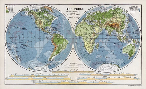
Pillow : The world in hemispheres showing height of the land and depth of the sea (colour litho)
![]()

Home Decor from Fine Art Finder
The world in hemispheres showing height of the land and depth of the sea (colour litho)
3630822 The world in hemispheres showing height of the land and depth of the sea (colour litho) by English School, (20th century); Private Collection; (add.info.: The world in hemispheres showing height of the land and depth of the sea. Illustration for An Atlas of Commercial Geography compiled by Fawcett Allen (Cambridge, 1913).); © Look and Learn
Media ID 23637548
© Look and Learn / Bridgeman Images
Commercial Depth Geographical Height Hemispheres Interesting Land Unusual
18"x18" (46x46cm) Pillow
18"x18" (46x46cm) Faux Suede Pillow with a plush soft feel. Your choice of image fills the front, with a stone colored faux suede back. Flat sewn concealed white zip.
Accessorise your space with decorative, soft pillows
Estimated Product Size is 45.7cm x 45.7cm (18" x 18")
These are individually made so all sizes are approximate
Artwork printed orientated as per the preview above, with landscape (horizontal) or portrait (vertical) orientation to match the source image.
FEATURES IN THESE COLLECTIONS
> Europe
> France
> Canton
> Landes
> Maps and Charts
> Related Images
> Maps and Charts
> World
EDITORS COMMENTS
This print titled "The world in hemispheres showing height of the land and depth of the sea" offers a unique perspective on our planet's geography. Created by an English School artist in the 20th century, this colour lithograph showcases an unusual depiction of the Earth's surface. In this image, two hemispheres divide the world into distinct regions. The contrasting colours beautifully illustrate both the height of landmasses and the depths of our vast oceans. This artistic representation provides viewers with a visually striking way to understand global topography. Originally featured as an illustration for An Atlas of Commercial Geography compiled by Fawcett Allen in Cambridge back in 1913, this print holds historical significance as well. It serves as a testament to how cartography has evolved over time and highlights its importance in understanding our planet's diverse landscapes. Whether you have a keen interest in geography or simply appreciate intriguing artwork, this print is sure to captivate your imagination. Its combination of vibrant colours, intricate details, and unconventional approach makes it stand out among traditional maps. Displayed proudly within a private collection, this piece from Bridgeman Images allows us to explore new perspectives on familiar terrain while reminding us just how fascinating and complex our world truly is.
MADE IN THE USA
Safe Shipping with 30 Day Money Back Guarantee
FREE PERSONALISATION*
We are proud to offer a range of customisation features including Personalised Captions, Color Filters and Picture Zoom Tools
SECURE PAYMENTS
We happily accept a wide range of payment options so you can pay for the things you need in the way that is most convenient for you
* Options may vary by product and licensing agreement. Zoomed Pictures can be adjusted in the Cart.


