Pillow > Fine Art Finder > Schools > English School
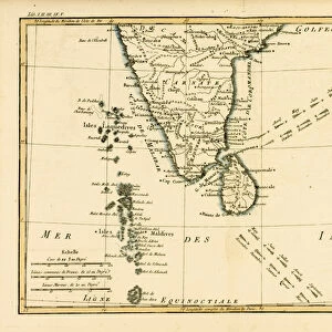
Pillow : Map of Southern India, 1898 (colour lithograph)
")
")

Please select a smaller print size for this image
![]()
Home Decor from Fine Art Finder
Map of Southern India, 1898 (colour lithograph)
XCF267429 Map of Southern India, 1898 (colour lithograph) by English School, (20th century); Private Collection; English, out of copyright
Media ID 12786457
© www.bridgemanimages.com
Bay Of Bengal Boundaries British Empire British Raj Ceylon Countries Islands States Maldive Islands Maldives
18"x18" (46x46cm) Pillow
18"x18" (46x46cm) Faux Suede Pillow with a plush soft feel. Your choice of image fills the front, with a stone colored faux suede back. Flat sewn concealed white zip.
Accessorise your space with decorative, soft pillows
Estimated Product Size is 45.7cm x 45.7cm (18" x 18")
These are individually made so all sizes are approximate
Artwork printed orientated as per the preview above, with landscape (horizontal) or portrait (vertical) orientation to match the source image.
EDITORS COMMENTS
This print showcases a beautifully detailed "Map of Southern India, 1898". Created as a colour lithograph by the English School in the 20th century, this map offers a glimpse into the rich cartography of that era. The vibrant colours and intricate lines bring to life the various islands and states that make up Southern India. From the Laccadive Islands to the Maldive Islands, every detail is meticulously depicted. The boundaries between countries and states are clearly marked, providing an accurate representation of geography at that time. One cannot help but be fascinated by the historical context surrounding this map. It reflects an important period when British influence was prominent in Asia, particularly within their empire known as British Raj. This connection is evident through references to Ceylon (now Sri Lanka) and its proximity to India. The Bay of Bengal takes center stage on this map, showcasing its significance as a major body of water in Asian history and trade routes. As we gaze upon this remarkable piece from a private collection, it serves as both an educational tool for understanding past geographies and a testament to human curiosity about our world's landscapes. With each glance at this mesmerizing image, one can't help but appreciate how far we have come in our knowledge of these regions since 1898.
MADE IN THE USA
Safe Shipping with 30 Day Money Back Guarantee
FREE PERSONALISATION*
We are proud to offer a range of customisation features including Personalised Captions, Color Filters and Picture Zoom Tools
SECURE PAYMENTS
We happily accept a wide range of payment options so you can pay for the things you need in the way that is most convenient for you
* Options may vary by product and licensing agreement. Zoomed Pictures can be adjusted in the Cart.